Baisley Park
Neighborhood · Queens
Baisley Park takes in the blocks around Baisley Pond Park in southeast Queens, where South Jamaica, Rochdale and St. Albans meet.
- 1.72 square miles
- 43,090 residents, 2020 Census
- 331 street corners
- 17 bus routes
The pond began in the 1700s when farmers dammed streams to power a grain mill, and it carries the name of David Baisley, the mill's owner, who sold it in 1852 to supply Brooklyn's water system. In 1858 workers digging in the pond uncovered the bones of a mastodon, and a sculpture of the animal stands in the park today. Opened to the public in 1919, the park surrounds its 30-acre pond with playgrounds and sports facilities.
Sources: Baisley Pond Park (Wikipedia); The Remains of a Mammoth Exhumed (The Walt Whitman Archive).
Baisley Park borders five areas, and 116th Avenue holds more of its corners than any other street, 29 of 331.
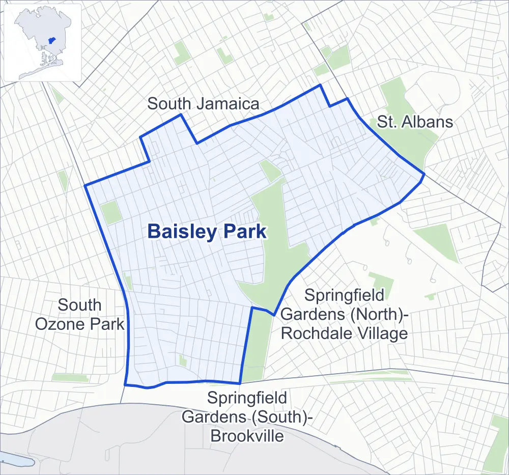
- Baisley Park
- A neighboring area
- Park
Neighborhood areas and streets: NYC Department of City Planning. Parks: NYC Parks. Stations: MTA.
Neighboring areas
- South Jamaica north
- St. Albans northeast
- Springfield Gardens (North)-Rochdale Village southeast
- Springfield Gardens (South)-Brookville south
- South Ozone Park southwest
Getting around
Buses on 17 routes stop in or at the edge of Baisley Park.
- 14 local bus routes
- 3 express bus routes
Local bus routes
- Q5
- Q6
- Q7
- Q40
- Q51
- Q84
- Q85
- Q86
- Q87
- Q89
- Q111
- Q113
- Q114
- Q115
Express bus routes
- QM21
- QM63
- QM65
Safety record
Between 2021 and 2025, its corners averaged more police-reported crashes than the average Queens corner.
- 2,137 police-reported crashes at its corners
- 6.5 a corner, on average
- 5.2 the average Queens corner
- 24 corners with a clean record
Signal or safety changes on City record, at 30 of its corners
- Leading pedestrian intervals
- 25
- Accessible pedestrian signals
- 9
- Turn calming
- 2
- Barnes Dance all-way crossings
- 1
- Safety Improvement Projects
- 1
Camera tickets
In 2025 its corners had more school-zone speed camera tickets than red-light or bus-lane tickets.
- 0 red-light camera tickets
- 20,016 school-zone speed camera tickets at 16 corners
- 0 bus-lane camera tickets
- Most speed tickets
- 167th Street & Baisley Boulevard, 3,467
People and homes
The 2020 Census counted 43,090 residents in Baisley Park, about 25,100 per square mile.
- 13,445 homes, 2020 Census
- 743 homes added since April 2010, net, by City Planning's count
Half of its 8,237 residential lots hold buildings from 1930 or earlier, and 63% of them date from before 1940, by the City's tax lot records.
NYCHA developments
NYCHA's Baisley Park, FHA Repossessed Houses (Group II), FHA Repossessed Houses (Group III), FHA Repossessed Houses (Group I), FHA Repossessed Houses (Group IX), FHA Repossessed Houses (Group VI) and FHA Repossessed Houses (Group VIII) developments lie wholly or partly within Baisley Park.
- Baisley Park
- Within Baisley Park
- FHA Repossessed Houses (Group II)
- Partly within Baisley Park
- FHA Repossessed Houses (Group III)
- Partly within Baisley Park
- FHA Repossessed Houses (Group I)
- Partly within Baisley Park
- FHA Repossessed Houses (Group IX)
- Partly within Baisley Park
- FHA Repossessed Houses (Group VI)
- Partly within Baisley Park
- FHA Repossessed Houses (Group VIII)
- Partly within Baisley Park
Parks
- Parkland
- 91.1 acres of NYC Parks property
- The largest pieces
- Baisley Pond Park (81.9 acres), Dr. Charles R. Drew Park (6.4 acres) and Playground One Forty (1.4 acres)
Streets and trees
- Trees
- 7,122 in NYC Parks' records, most often London planetree, pin oak and thornless honeylocust
- Street with the most corners
- 116th Avenue, with 29 of the area's 331
- Height above sea level
- From 9 feet at North Conduit Avenue & Van Wyck Expressway to 38 feet at 116th Avenue & 142nd Street
- Honorary street names
- 3 at its corners, enacted by local law
Schools and libraries
The City lists nine schools and one library in Baisley Park.
- Public schools
- 7
- Charter and private schools
- 2
- Library
- Baisley Park Library
Public art
The City's public art inventory lists one work in Baisley Park: Baisley Pond Park Memorial (1921).
- 1 work of public art
Public safety
How complaints are countedIn 2025 the NYPD recorded 405 major felonies at places in Baisley Park.
Recorded by the NYPD at places in Baisley Park
- 325 major felonies in 2024
- 1,855 other felonies, misdemeanors and violations in 2025
In 2025, on the streets along the edge of Baisley Park, the NYPD recorded another 77 major felonies. Counting the streets along its edge, in 2025 the NYPD recorded 11.2 major felonies for every thousand residents the 2020 Census counted in Baisley Park.
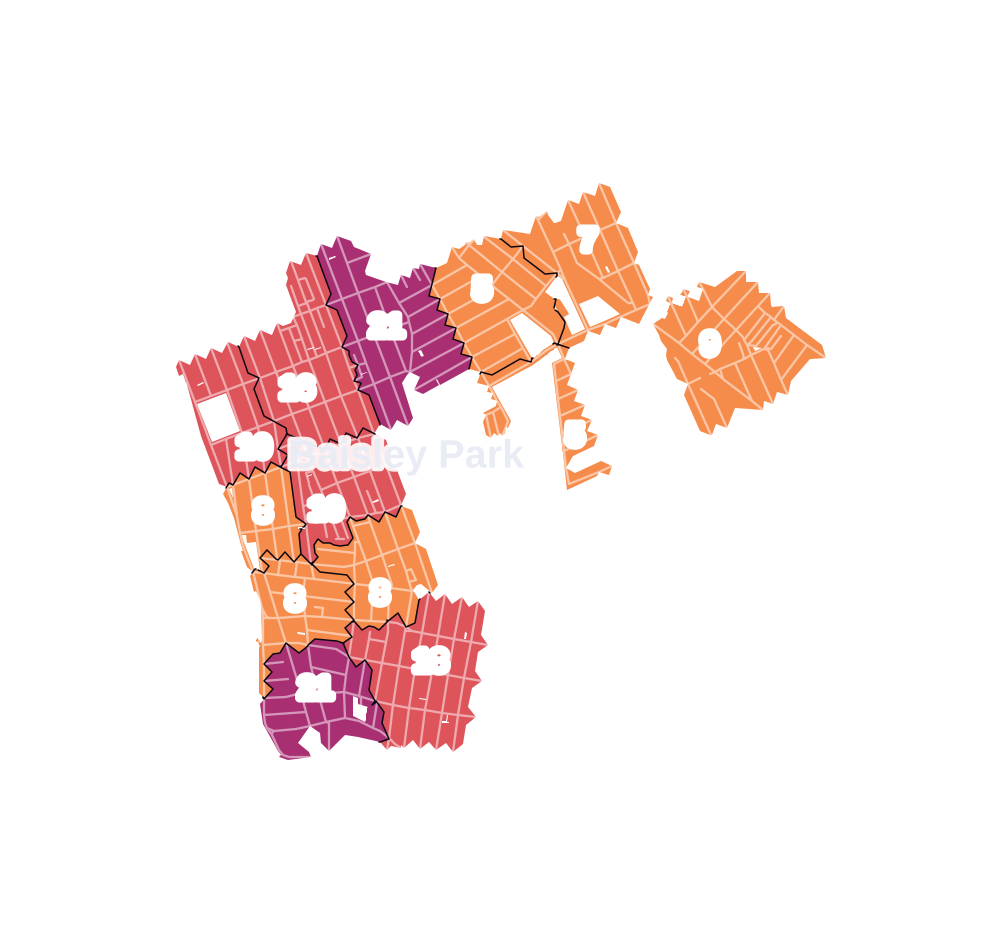
- 5 to 9
- 10 to 19
- 20 to 49
- 50 to 99
- 100 or more
- Not shaded: fewer than 5, held back under the rules in How complaints are counted, parks and public-housing grounds, and land in no patch
- Police precinct
- 113th
From January to June 2026 the NYPD recorded 169 major felonies at places in Baisley Park, against 171 in the same months of 2025.
Sources: the NYPD's Complaint Data Historic, updated April 28, 2026, and Complaint Data Current (Year To Date), updated July 27, 2026, on NYC Open Data. Figures to June 30, 2026.
Street corners
- 111th Avenue & 146th Street
- 111th Avenue & Inwood Street
- 115th Avenue & 139th Street
- 115th Avenue & 140th Street
- 115th Avenue & 141st Street
- 115th Avenue & 142nd Street
- 115th Avenue & 143rd Street
- 115th Avenue & 144th Street
- 115th Avenue & 145th Street
- 115th Avenue & 146th Street
- 115th Avenue & 155th Street
- 115th Avenue & Guy R Brewer Boulevard
- 115th Avenue & Inwood Street
- 115th Avenue & Marsden Street
- 115th Avenue & Sutphin Boulevard
- 115th Road & Bedell Street
- 116th Avenue & 139th Street
- 116th Avenue & 140th Street
- 116th Avenue & 141st Street
- 116th Avenue & 142nd Street
- 116th Avenue & 143rd Street
- 116th Avenue & 144th Street
- 116th Avenue & 145th Street
- 116th Avenue & 146th Street
- 116th Avenue & 148th Street
- 116th Avenue & 149th Street
- 116th Avenue & 155th Street
- 116th Avenue & 158th Street
- 116th Avenue & 165th Street
- 116th Avenue & 167th Street
- 116th Avenue & 171st Street
- 116th Avenue & Barron Street
- 116th Avenue & Bedell Street
- 116th Avenue & Guy R Brewer Boulevard
- 116th Avenue & Inwood Street
- 116th Avenue & Marsden Street
- 116th Avenue & Sutphin Boulevard
- 116th Drive & Barron Street
- 116th Road & Barron Street
- 118th Avenue & 152nd Street
- 118th Avenue & Lakeview Boulevard East
- 118th Avenue & Long Street
- 118th Avenue & Marsden Street
- 118th Road & Lakeview Boulevard East
- 118th Road & Long Street
- 118th Road & Ring Place
- 119th Avenue & 143rd Street
- 119th Avenue & 144th Street
- 119th Avenue & 145th Street
- 119th Avenue & 152nd Street
- 119th Avenue & 153rd Street
- 119th Avenue & 154th Street
- 119th Avenue & Inwood Street
- 119th Avenue & Lakeview Boulevard East
- 119th Avenue & Long Street
- 119th Avenue & Marsden Street
- 119th Avenue & Merrill Street
- 119th Avenue & Ring Place
- 119th Road & 142nd Place
- 119th Road & Lakeview Boulevard East
- 119th Road & Long Street
- 119th Road & Merrill Street
- 120th Avenue & 140th Street
- 120th Avenue & 141st Street
- 120th Avenue & 142nd Place
- 120th Avenue & 142nd Street
- 120th Avenue & 143rd Street
- 120th Avenue & 144th Street
- 120th Avenue & 145th Street
- 120th Avenue & 146th Street
- 120th Avenue & 153rd Street
- 120th Avenue & 171st Street
- 120th Avenue & Inwood Street
- 120th Avenue & Lakeview Boulevard East
- 120th Avenue & Long Street
- 120th Avenue & Marsden Street
- 120th Avenue & Smith Street
- 120th Avenue & Sutphin Boulevard
- 121st Avenue & Lakeview Boulevard East
- 121st Avenue & Long Street
- 122nd Avenue & 161st Place
- 122nd Avenue & Lakeview Lane
- 122nd Avenue & Long Street
- 122nd Avenue & Smith Street
- 123rd Avenue & 142nd Place
- 130th Avenue & 140th Street
- 130th Avenue & 142nd Street
- 130th Avenue & 143rd Street
- 130th Avenue & 144th Street
- 130th Avenue & 145th Street
- 130th Avenue & Inwood Street
- 133rd Avenue & 140th Street
- 133rd Avenue & 143rd Street
- 133rd Avenue & 144th Street
- 133rd Avenue & 145th Street
- 133rd Avenue & 146th Street
- 133rd Avenue & 148th Street
- 133rd Avenue & 149th Street
- 133rd Avenue & Inwood Street
- 135th Avenue & 140th Street
- 135th Avenue & 142nd Street
- 135th Avenue & 143rd Street
- 135th Avenue & 145th Street
- 135th Avenue & Inwood Street
- 139th Street & Foch Boulevard
- 140th Street & 123rd Avenue
- 140th Street & 134th Avenue
- 140th Street & Bascom Avenue
- 141st Street & 123rd Avenue
- 141st Street & Foch Boulevard
- 142nd Street & 116th Road
- 142nd Street & 123rd Avenue
- 142nd Street & 129th Avenue
- 142nd Street & 131st Avenue
- 142nd Street & Bascom Avenue
- 142nd Street & Foch Boulevard
- 143rd Street & 116th Road
- 143rd Street & 119th Road
- 143rd Street & 122nd Avenue
- 143rd Street & 123rd Avenue
- 143rd Street & 129th Avenue
- 143rd Street & 131st Avenue
- 143rd Street & 144th Street
- 143rd Street & Bascom Avenue
- 143rd Street & Foch Boulevard
- 144th Street & 123rd Avenue
- 144th Street & 129th Avenue
- 144th Street & Foch Boulevard
- 145th Street & 123rd Avenue
- 145th Street & 129th Avenue
- 146th Street & 119th Avenue
- 146th Street & 123rd Avenue
- 146th Street & 130th Avenue
- 146th Street & Foch Boulevard
- 146th Street & Sutter Avenue
- 147th Street & 115th Avenue
- 147th Street & 116th Avenue
- 147th Street & 119th Avenue
- 147th Street & 120th Avenue
- 147th Street & 123rd Avenue
- 147th Street & 130th Avenue
- 147th Street & 133rd Avenue
- 147th Street & Foch Boulevard
- 147th Street & Sutter Avenue
- 148th Street & 112th Avenue
- 148th Street & 115th Avenue
- 148th Street & 130th Avenue
- 148th Street & Foch Boulevard
- 148th Street & Sutter Avenue
- 149th Street & 115th Avenue
- 149th Street & 130th Avenue
- 149th Street & Sutter Avenue
- 150th Street & 133rd Avenue
- 150th Street & Rockaway Boulevard
- 152nd Street & 123rd Avenue
- 152nd Street & 125th Avenue
- 153rd Street & 118th Avenue
- 153rd Street & 119th Road
- 153rd Street & 121st Avenue
- 153rd Street & 122nd Avenue
- 153rd Street & 123rd Avenue
- 153rd Street & 124th Avenue
- 153rd Street & 125th Avenue
- 155th Street & 114th Road
- 155th Street & 115th Drive
- 155th Street & 115th Road
- 155th Street & 116th Drive
- 155th Street & 116th Road
- 155th Street & 118th Avenue
- 155th Street & 119th Avenue
- 155th Street & 119th Road
- 155th Street & 120th Avenue
- 155th Street & 121st Avenue
- 155th Street & 122nd Avenue
- 155th Street & 123rd Avenue
- 155th Street & 124th Avenue
- 155th Street & 125th Avenue
- 155th Street & Foch Boulevard
- 157th Street & 114th Road
- 157th Street & 115th Avenue
- 157th Street & 115th Drive
- 157th Street & 115th Road
- 157th Street & 116th Avenue
- 157th Street & Baisley Boulevard
- 157th Street & Foch Boulevard
- 157th Street & Meyer Avenue
- 158th Street & 115th Road
- 158th Street & Meyer Avenue
- 159th Street & 115th Road
- 159th Street & 116th Avenue
- 160th Street & Baisley Boulevard
- 164th Street & 119th Avenue
- 164th Street & 120th Avenue
- 164th Street & 122nd Avenue
- 164th Street & Foch Boulevard
- 165th Street & 115th Avenue
- 165th Street & 119th Avenue
- 165th Street & 120th Avenue
- 165th Street & Foch Boulevard
- 165th Street & Smith Street
- 166th Street & 115th Avenue
- 166th Street & 116th Avenue
- 166th Street & 119th Avenue
- 166th Street & 120th Avenue
- 166th Street & Baisley Boulevard
- 166th Street & Foch Boulevard
- 166th Street & Marsden Street
- 166th Street & Smith Street
- 167th Street & 115th Avenue
- 167th Street & 120th Avenue
- 167th Street & Baisley Boulevard
- 167th Street & Foch Boulevard
- 168th Street & 115th Avenue
- 168th Street & 116th Avenue
- 168th Street & 118th Avenue
- 168th Street & Bedell Street
- 168th Street & Foch Boulevard
- 169th Street & 115th Avenue
- 169th Street & 116th Avenue
- 169th Street & 118th Avenue
- 169th Street & Foch Boulevard
- 170th Street & 116th Avenue
- 170th Street & 118th Avenue
- 170th Street & 120th Avenue
- 170th Street & Foch Boulevard
- 170th Street & Marsden Street
- 171st Street & Baisley Boulevard
- 171st Street & Foch Boulevard
- 172nd Street & Amelia Road
- 172nd Street & Baisley Boulevard
- 172nd Street & Baisley Boulevard at 125th Avenue
- 172nd Street & Brocher Road
- Baisley Boulevard & 129th Avenue
- Baisley Boulevard & 154th Street
- Baisley Boulevard & 161st Place
- Baisley Boulevard & Bedell Street
- Baisley Boulevard & Long Street
- Baisley Boulevard & Smith Street
- Foch Boulevard & 140th Street
- Foch Boulevard & 142nd Place
- Foch Boulevard & 145th Street
- Foch Boulevard & Barron Street
- Foch Boulevard & Inwood Street
- Guy R Brewer Boulevard & 118th Avenue
- Guy R Brewer Boulevard & 118th Road
- Guy R Brewer Boulevard & 119th Avenue
- Guy R Brewer Boulevard & 119th Drive
- Guy R Brewer Boulevard & 119th Road
- Guy R Brewer Boulevard & 120th Avenue
- Guy R Brewer Boulevard & 121st Avenue
- Guy R Brewer Boulevard & 122nd Avenue
- Guy R Brewer Boulevard & Baisley Boulevard
- Guy R Brewer Boulevard & Bedell Street
- Guy R Brewer Boulevard & Foch Boulevard
- Inwood Street & 123rd Avenue
- Lakeview Boulevard East & 119th Drive
- Linden Boulevard & 141st Street
- Linden Boulevard & 142nd Street
- Linden Boulevard & 143rd Street
- Linden Boulevard & 145th Street
- Linden Boulevard & 146th Street
- Linden Boulevard & 147th Street
- Linden Boulevard & 148th Street
- Linden Boulevard & 149th Street
- Linden Boulevard & 157th Street
- Linden Boulevard & 158th Street
- Linden Boulevard & 165th Street
- Linden Boulevard & 166th Street
- Linden Boulevard & 167th Street
- Linden Boulevard & 168th Street
- Linden Boulevard & 169th Street
- Linden Boulevard & Bedell Street
- Linden Boulevard & Dillon Street
- Linden Boulevard & Inwood Street
- Linden Boulevard & Meyer Avenue
- Long Street & 119th Drive
- Marsden Street & 118th Road
- Marsden Street & Smith Street
- Merrick Boulevard & 115th Avenue
- Merrick Boulevard & Foch Boulevard
- Merrick Boulevard & Victoria Road
- Merrill Street & Amelia Road
- Merrill Street & Brocher Road
- Merrill Street & Victoria Drive
- Merrill Street & Victoria Road
- North Conduit Avenue & 146th Street
- North Conduit Avenue & 147th Street
- North Conduit Avenue & 148th Street
- North Conduit Avenue & Van Wyck Expressway
- Rockaway Boulevard & 140th Street
- Rockaway Boulevard & 141st Street
- Rockaway Boulevard & 142nd Place
- Rockaway Boulevard & 142nd Street
- Rockaway Boulevard & 143rd Street
- Rockaway Boulevard & 144th Street
- Rockaway Boulevard & 145th Street
- Rockaway Boulevard & 146th Street
- Rockaway Boulevard & 147th Street
- Rockaway Boulevard & 148th Street
- Rockaway Boulevard & 149th Street
- Rockaway Boulevard & Inwood Street
- Rockaway Boulevard & Sutphin Boulevard
- Sutphin Boulevard & 111th Road
- Sutphin Boulevard & 113th Avenue
- Sutphin Boulevard & 114th Road
- Sutphin Boulevard & 115th Drive
- Sutphin Boulevard & 115th Road
- Sutphin Boulevard & 116th Drive
- Sutphin Boulevard & 116th Road
- Sutphin Boulevard & 118th Avenue
- Sutphin Boulevard & 119th Avenue
- Sutphin Boulevard & 119th Road
- Sutphin Boulevard & 121st Avenue
- Sutphin Boulevard & 122nd Avenue
- Sutphin Boulevard & 123rd Avenue
- Sutphin Boulevard & 125th Avenue
- Sutphin Boulevard & Foch Boulevard
- Sutter Avenue & 140th Street
- Sutter Avenue & 142nd Street
- Sutter Avenue & 143rd Street
- Sutter Avenue & 144th Street
- Sutter Avenue & 145th Street
- Sutter Avenue & Inwood Street
- Van Wyck Expressway & 115th Avenue
- Van Wyck Expressway & 116th Avenue
- Van Wyck Expressway & 120th Avenue
- Van Wyck Expressway & 131st Avenue
- Van Wyck Expressway & 132nd Avenue
- Van Wyck Expressway & 134th Avenue
- Van Wyck Expressway & 135th Avenue
- Van Wyck Expressway & 139th Street
How the figures above are measured: Methodology.