South Ozone Park
Neighborhood · Queens
Just north of John F. Kennedy International Airport, South Ozone Park reaches east from Aqueduct Racetrack to the Van Wyck Expressway, with Richmond Hill to the north and Howard Beach to the southwest.
- 2.94 square miles
- 79,540 residents, 2020 Census
- 488 street corners
- 5 subway stations
- 11 bus routes
Its chief commercial street is Rockaway Boulevard, and the neighborhood is home to sizable Guyanese and Trinidadian communities. Aqueduct opened in 1894 and took its name from the old Ridgewood Aqueduct, a conduit of the Brooklyn waterworks; it hosted the second Breeders' Cup in 1985, and after 132 years its final day of live racing came on June 28, 2026.
Sources: South Ozone Park (Wikipedia); Aqueduct Racetrack (Wikipedia); Aqueduct Racetrack (New York Racing Association); Queens Community Board 10.
South Ozone Park borders eight areas, and Rockaway Boulevard holds more of its corners than any other street, 43 of 488.
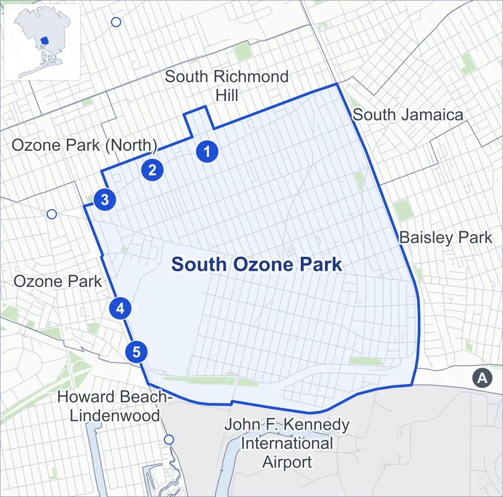
- South Ozone Park
- A neighboring area
- Park
- A station in the list
- Another station
Neighborhood areas and streets: NYC Department of City Planning. Parks: NYC Parks. Stations: MTA.
Neighboring areas
- South Richmond Hill north
- South Jamaica northeast
- Baisley Park east
- Springfield Gardens (South)-Brookville southeast
- John F. Kennedy International Airport south
- Howard Beach-Lindenwood southwest
- Ozone Park west
- Ozone Park (North) northwest
Subway stations
- Ozone Park-Lefferts Blvd lines A accessible
- 111 St lines A
- 104 St lines A
- Aqueduct Racetrack lines A accessible
- Aqueduct-N Conduit Av lines A
Getting around
Five subway stations and buses on 11 routes stop in or at the edge of South Ozone Park.
- 5 subway stations
- 2 of them listed by the MTA as fully accessible
- 10 local bus routes
- 1 express bus route
Local bus routes
- Q7
- Q8
- Q9
- Q10
- Q37
- Q41
- Q51
- Q80
- Q109
- Q112
Express bus route
- QM18
Safety record
Between 2021 and 2025, its corners averaged more police-reported crashes than the average Queens corner.
- 3,447 police-reported crashes at its corners
- 7.1 a corner, on average
- 5.2 the average Queens corner
- 38 corners with a clean record
Signal or safety changes on City record, at 73 of its corners
- Accessible pedestrian signals
- 54
- Leading pedestrian intervals
- 45
- Turn calming
- 6
- Barnes Dance all-way crossings
- 1
- Safety Improvement Projects
- 1
Camera tickets
In 2025 its corners had more school-zone speed camera tickets than red-light or bus-lane tickets.
- 1,377 red-light camera tickets at one corner
- 57,168 school-zone speed camera tickets at 17 corners
- 0 bus-lane camera tickets
- Most red-light tickets
- North Conduit Avenue & Lefferts Boulevard, 1,377
- Most speed tickets
- North Conduit Avenue & 127th Street, 33,650
People and homes
The 2020 Census counted 79,540 residents in South Ozone Park, about 27,100 per square mile.
- 24,391 homes, 2020 Census
- 435 homes added since April 2010, net, by City Planning's count
Half of its 13,932 residential lots hold buildings from 1925 or earlier, and 77% of them date from before 1940, by the City's tax lot records.
NYCHA developments
NYCHA's FHA Repossessed Houses (Group VII), FHA Repossessed Houses (Group IV), FHA Repossessed Houses (Group VIII) and FHA Repossessed Houses (Group III) developments lie wholly or partly within South Ozone Park.
- FHA Repossessed Houses (Group VII)
- Partly within South Ozone Park
- FHA Repossessed Houses (Group IV)
- Partly within South Ozone Park
- FHA Repossessed Houses (Group VIII)
- Partly within South Ozone Park
- FHA Repossessed Houses (Group III)
- Partly within South Ozone Park
Parks
- Parkland
- 16.4 acres of NYC Parks property
- The largest pieces
- Southern Fields (5.6 acres), Police Officer Edward Byrne Park (4.7 acres) and Lefferts Playground (2.9 acres)
Streets and trees
- Trees
- 8,369 in NYC Parks' records, most often London planetree, thornless honeylocust and pin oak
- Street with the most corners
- Rockaway Boulevard, with 43 of the area's 488
- Height above sea level
- From 12 feet at Nassau Expressway & South Conduit Avenue to 49 feet at Liberty Avenue & 129th Street
- Honorary street names
- 8 at its corners, enacted by local law
Schools and libraries
The City lists 15 schools and two libraries in South Ozone Park.
- Public schools
- 10
- Charter and private schools
- 5
- Libraries
- Lefferts Library and South Ozone Park Library
Public art
The City's public art inventory lists two works in South Ozone Park: Corporal George J. Wellbrock Memorial (1929) and Catholic War Veterans Memorial (1938).
- 2 works of public art
Public safety
How complaints are countedIn 2025 the NYPD recorded 921 major felonies at places in South Ozone Park.
Recorded by the NYPD at places in South Ozone Park
- 968 major felonies in 2024
- 2,791 other felonies, misdemeanors and violations in 2025
In 2025, on the streets along the edge of South Ozone Park, the NYPD recorded another 56 major felonies. Counting the streets along its edge, in 2025 the NYPD recorded 12.3 major felonies for every thousand residents the 2020 Census counted in South Ozone Park.
- Police precincts
- 106th (most of the area), 102nd
From January to June 2026 the NYPD recorded 484 major felonies at places in South Ozone Park, against 424 in the same months of 2025.
Sources: the NYPD's Complaint Data Historic, updated April 28, 2026, and Complaint Data Current (Year To Date), updated July 27, 2026, on NYC Open Data. Figures to June 30, 2026.
Street corners
- 103rd Avenue & 107th Street
- 103rd Avenue & 109th Street
- 103rd Avenue & 131st Street
- 103rd Street & Centreville Street
- 103rd Street & Plattwood Avenue
- 105th Street & 103rd Drive
- 105th Street & 103rd Road
- 106th Street & Rosita Road
- 107th Avenue & 104th Street
- 107th Avenue & 105th Street
- 107th Avenue & 106th Street
- 107th Avenue & 107th Street
- 107th Avenue & 109th Street
- 107th Avenue & 110th Street
- 107th Avenue & 111th Street
- 107th Avenue & 112th Street
- 107th Avenue & 113th Street
- 107th Avenue & 115th Street
- 107th Avenue & 116th Street
- 107th Avenue & 117th Street
- 107th Avenue & 118th Street
- 107th Avenue & 121st Street
- 107th Avenue & 122nd Street
- 107th Avenue & 128th Street
- 107th Avenue & 129th Street
- 107th Avenue & 131st Street
- 107th Avenue & 132nd Street
- 107th Avenue & 133rd Street
- 107th Avenue & 135th Street
- 107th Street & Muriel Court
- 108th Street & 107th Avenue
- 109th Avenue & 106th Street
- 109th Avenue & 107th Street
- 109th Avenue & 108th Street
- 109th Avenue & 109th Street
- 109th Avenue & 110th Street
- 109th Avenue & 111th Street
- 109th Avenue & 112th Street
- 109th Avenue & 113th Street
- 109th Avenue & 114th Street
- 109th Avenue & 115th Street
- 109th Avenue & 116th Street
- 109th Avenue & 117th Street
- 109th Avenue & 118th Street
- 109th Avenue & 120th Street
- 109th Avenue & 121st Street
- 109th Avenue & 122nd Street
- 109th Avenue & 123rd Street
- 109th Avenue & 124th Street
- 109th Avenue & 125th Street
- 109th Avenue & 126th Street
- 109th Avenue & 127th Street
- 109th Avenue & 128th Street
- 109th Avenue & 129th Street
- 109th Avenue & 130th Street
- 109th Avenue & 130th Street at Hawtree Creek Road
- 109th Avenue & 131st Street
- 109th Avenue & 132nd Street
- 109th Avenue & 133rd Street
- 109th Avenue & 134th Street
- 109th Avenue & 135th Street
- 109th Avenue & Lefferts Boulevard
- 111th Avenue & 110th Street
- 111th Avenue & 111th Street
- 111th Avenue & 112th Street
- 111th Avenue & 113th Street
- 111th Avenue & 114th Street
- 111th Avenue & 115th Street
- 111th Avenue & 116th Street
- 111th Avenue & 117th Street
- 111th Avenue & 118th Street
- 111th Avenue & 120th Street
- 111th Avenue & 121st Street
- 111th Avenue & 122nd Street
- 111th Avenue & 124th Street
- 111th Avenue & 125th Street
- 111th Avenue & 126th Street
- 111th Avenue & 127th Street
- 111th Avenue & 128th Street
- 111th Avenue & 130th Street
- 111th Avenue & 131st Street
- 111th Avenue & 132nd Street
- 111th Avenue & 133rd Street
- 111th Avenue & 135th Street
- 111th Avenue & Hawtree Creek Road
- 112th Street & 103rd Avenue
- 113th Street & 103rd Avenue
- 114th Street & 107th Avenue
- 114th Street & 135th Avenue
- 114th Street & 149th Avenue
- 114th Street & Sutter Avenue
- 115th Avenue & 118th Street
- 115th Avenue & 120th Street
- 115th Avenue & 121st Street
- 115th Avenue & 122nd Street
- 115th Avenue & 124th Street
- 115th Avenue & 125th Street
- 115th Avenue & 126th Street
- 115th Avenue & 127th Street
- 115th Avenue & 128th Street
- 115th Avenue & 130th Street
- 115th Avenue & 131st Street
- 115th Avenue & 132nd Street
- 115th Avenue & 133rd Street
- 115th Avenue & 135th Street
- 115th Avenue & Lincoln Street
- 115th Street & 150th Avenue
- 115th Street & Sutter Avenue
- 116th Avenue & 122nd Street
- 116th Avenue & 123rd Street
- 116th Avenue & 124th Street
- 116th Avenue & 125th Street
- 116th Avenue & 126th Street
- 116th Avenue & 127th Street
- 116th Avenue & 128th Street
- 116th Avenue & 130th Street
- 116th Avenue & 131st Street
- 116th Avenue & 132nd Street
- 116th Avenue & 133rd Street
- 116th Avenue & 135th Street
- 116th Avenue & Lincoln Street
- 116th Street & 103rd Avenue
- 116th Street & 150th Avenue
- 116th Street & Sutter Avenue
- 117th Street & 103rd Avenue
- 117th Street & 150th Avenue
- 117th Street & Sutter Avenue
- 118th Street & 103rd Avenue
- 118th Street & 150th Avenue
- 118th Street & Old South Road
- 118th Street & Sutter Avenue
- 120th Avenue & 133rd Street
- 120th Avenue & 135th Street
- 120th Street & 107th Avenue
- 120th Street & 149th Avenue
- 120th Street & 150th Avenue
- 120th Street & Hawtree Creek Road
- 120th Street & Sutter Avenue
- 121st Street & 103rd Avenue
- 121st Street & 150th Avenue
- 121st Street & Hawtree Creek Road (north)
- 121st Street & Hawtree Creek Road (south)
- 121st Street & Sutter Avenue
- 122nd Street & Hawtree Creek Road
- 123rd Street & 103rd Avenue
- 123rd Street & 107th Avenue
- 123rd Street & 111th Avenue
- 123rd Street & 115th Avenue
- 123rd Street & 135th Avenue
- 123rd Street & 149th Avenue
- 123rd Street & 150th Avenue
- 123rd Street & Hawtree Creek Road
- 123rd Street & Sutter Avenue
- 124th Street & 103rd Avenue
- 124th Street & 107th Avenue
- 124th Street & 135th Avenue
- 124th Street & 149th Avenue
- 124th Street & Hawtree Creek Road
- 124th Street & Old South Road
- 124th Street & Sutter Avenue
- 125th Street & 103rd Avenue
- 125th Street & 107th Avenue
- 125th Street & 149th Avenue
- 125th Street & 152nd Avenue
- 125th Street & Hawtree Creek Road
- 125th Street & Old South Road
- 125th Street & Sutter Avenue
- 126th Street & 107th Avenue
- 126th Street & 135th Avenue
- 126th Street & 149th Avenue
- 126th Street & 150th Avenue
- 126th Street & 152nd Avenue
- 126th Street & Hawtree Creek Road
- 126th Street & Old South Road
- 126th Street & Sutter Avenue
- 127th Street & 103rd Avenue
- 127th Street & 103rd Road
- 127th Street & 107th Avenue
- 127th Street & 135th Avenue
- 127th Street & 149th Avenue
- 127th Street & 150th Avenue
- 127th Street & Foch Boulevard
- 127th Street & Hawtree Creek Road
- 127th Street & Old South Road
- 127th Street & Sutter Avenue
- 128th Street & 150th Avenue
- 128th Street & 152nd Avenue
- 128th Street & Cedric Road
- 128th Street & Foch Boulevard
- 128th Street & Gotham Road
- 128th Street & Hawtree Creek Road
- 128th Street & Old South Road
- 129th Street & 103rd Road
- 129th Street & 150th Avenue
- 129th Street & Cedric Road
- 129th Street & Old South Road
- 130th Avenue & 135th Place
- 130th Place & 135th Road
- 130th Street & 103rd Avenue
- 130th Street & 107th Avenue
- 130th Street & 131st Avenue
- 130th Street & 150th Avenue
- 130th Street & Cedric Road
- 130th Street & Foch Boulevard
- 130th Street & Gotham Road
- 130th Street & Nassau Expressway
- 130th Street & Sutter Avenue
- 131st Avenue & 135th Place
- 131st Street & 131st Avenue
- 131st Street & 150th Avenue
- 131st Street & Foch Boulevard
- 131st Street & Van Siclen Street
- 132nd Street & 131st Avenue
- 132nd Street & 150th Avenue
- 132nd Street & Foch Boulevard
- 132nd Street & Lincoln Street
- 132nd Street & Van Siclen Street
- 133rd Avenue & 101st Street
- 133rd Avenue & 114th Place
- 133rd Avenue & 114th Street
- 133rd Avenue & 115th Street
- 133rd Avenue & 116th Street
- 133rd Avenue & 117th Street
- 133rd Avenue & 118th Street
- 133rd Avenue & 120th Street
- 133rd Avenue & 121st Street
- 133rd Avenue & 122nd Place
- 133rd Avenue & 122nd Street
- 133rd Avenue & 123rd Street
- 133rd Avenue & 124th Street
- 133rd Avenue & 125th Street
- 133rd Avenue & 126th Street
- 133rd Avenue & 127th Street
- 133rd Avenue & 128th Street
- 133rd Avenue & 129th Street
- 133rd Avenue & 130th Place
- 133rd Avenue & 130th Street
- 133rd Avenue & 131st Street
- 133rd Avenue & 132nd Street
- 133rd Avenue & 133rd Street
- 133rd Avenue & 135th Place
- 133rd Avenue & 135th Street
- 133rd Avenue & Boss Street
- 133rd Avenue & Hawtree Creek Road
- 133rd Avenue & Sutter Avenue
- 133rd Street & 105th Avenue
- 133rd Street & 117th Road
- 133rd Street & 131st Avenue
- 133rd Street & Foch Boulevard
- 133rd Street & Lincoln Street
- 134th Street & 105th Avenue
- 134th Street & 107th Avenue
- 134th Street & 111th Avenue
- 134th Street & 115th Avenue
- 134th Street & 116th Avenue
- 134th Street & 120th Avenue
- 134th Street & 131st Avenue
- 134th Street & 133rd Avenue
- 134th Street & 134th Avenue
- 134th Street & 135th Avenue
- 134th Street & 149th Avenue
- 134th Street & Foch Boulevard
- 134th Street & Lincoln Street
- 134th Street & Sutter Avenue
- 135th Avenue & 114th Place
- 135th Avenue & 115th Street
- 135th Avenue & 116th Street
- 135th Avenue & 117th Street
- 135th Avenue & 118th Street
- 135th Avenue & 120th Street
- 135th Avenue & 121st Street
- 135th Avenue & 122nd Place
- 135th Avenue & 122nd Street
- 135th Avenue & 125th Street
- 135th Avenue & 128th Street
- 135th Avenue & 129th Street
- 135th Avenue & 130th Place
- 135th Avenue & 130th Street
- 135th Avenue & 131st Street
- 135th Avenue & 131st Street at 135th Road
- 135th Avenue & 132nd Street
- 135th Avenue & 133rd Street
- 135th Avenue & 134th Place
- 135th Avenue & 135th Street
- 135th Avenue & Hawtree Creek Road
- 135th Place & Alwick Road
- 135th Street & 105th Avenue
- 135th Street & 131st Avenue
- 135th Street & 134th Avenue
- 135th Street & Foch Boulevard
- 135th Street & Lincoln Street
- 135th Street & Van Wyck Expressway
- 149th Avenue & 114th Place
- 149th Avenue & 115th Street
- 149th Avenue & 116th Street
- 149th Avenue & 117th Street
- 149th Avenue & 118th Street
- 149th Avenue & 121st Street
- 149th Avenue & 122nd Place
- 149th Avenue & 122nd Street
- 149th Avenue & 132nd Street
- 149th Avenue & 150th Avenue
- 150th Avenue & 114th Place
- 150th Avenue & 122nd Place
- 150th Avenue & 122nd Street
- Belt Parkway & 130th Street
- Belt Parkway & Lefferts Boulevard
- Centreville Street & Plattwood Avenue
- Centreville Street & Rosita Road
- Foch Boulevard & Lincoln Street
- Lefferts Boulevard & 103rd Avenue
- Lefferts Boulevard & 107th Avenue
- Lefferts Boulevard & 111th Avenue
- Lefferts Boulevard & 115th Avenue
- Lefferts Boulevard & 133rd Avenue
- Lefferts Boulevard & 135th Avenue
- Lefferts Boulevard & 149th Avenue
- Lefferts Boulevard & 150th Avenue
- Lefferts Boulevard & Nassau Expressway
- Lefferts Boulevard & South Conduit Avenue
- Lefferts Boulevard & Sutter Avenue
- Liberty Avenue & 102nd Street
- Liberty Avenue & 103rd Avenue at 133rd Street
- Liberty Avenue & 103rd Street
- Liberty Avenue & 105th Street
- Liberty Avenue & 106th Street
- Liberty Avenue & 107th Street
- Liberty Avenue & 108th Street
- Liberty Avenue & 109th Street
- Liberty Avenue & 110th Street
- Liberty Avenue & 111th Street
- Liberty Avenue & 112th Street
- Liberty Avenue & 113th Street
- Liberty Avenue & 114th Street
- Liberty Avenue & 115th Street
- Liberty Avenue & 116th Street
- Liberty Avenue & 117th Street
- Liberty Avenue & 118th Street
- Liberty Avenue & 120th Street
- Liberty Avenue & 121st Street
- Liberty Avenue & 122nd Street
- Liberty Avenue & 123rd Street
- Liberty Avenue & 124th Street
- Liberty Avenue & 125th Street
- Liberty Avenue & 126th Street
- Liberty Avenue & 127th Street
- Liberty Avenue & 128th Street
- Liberty Avenue & 129th Street
- Liberty Avenue & 130th Street
- Liberty Avenue & 131st Street
- Liberty Avenue & 132nd Street
- Liberty Avenue & 133rd Street
- Liberty Avenue & 134th Street
- Liberty Avenue & Lefferts Boulevard
- Linden Boulevard & 113th Street
- Linden Boulevard & 114th Street
- Linden Boulevard & 115th Street
- Linden Boulevard & 116th Street
- Linden Boulevard & 117th Street
- Linden Boulevard & 118th Street
- Linden Boulevard & 120th Street
- Linden Boulevard & 121st Street
- Linden Boulevard & 122nd Street
- Linden Boulevard & 123rd Street
- Linden Boulevard & 124th Street
- Linden Boulevard & 125th Street
- Linden Boulevard & 126th Street
- Linden Boulevard & 127th Street
- Linden Boulevard & 128th Street
- Linden Boulevard & 130th Street
- Linden Boulevard & 131st Street
- Linden Boulevard & 132nd Street
- Linden Boulevard & 133rd Street
- Linden Boulevard & 134th Street
- Linden Boulevard & 135th Street
- Linden Boulevard & Centreville Street
- Linden Boulevard & Hawtree Creek Road
- Linden Boulevard & Lefferts Boulevard
- Linden Boulevard & Lincoln Street
- Nassau Expressway & Lefferts Boulevard
- Nassau Expressway & South Conduit Avenue
- Nassau Expressway & South Conduit Avenue at Belt Parkway
- North Conduit Avenue & 114th Place
- North Conduit Avenue & 114th Street
- North Conduit Avenue & 115th Street
- North Conduit Avenue & 116th Street
- North Conduit Avenue & 117th Street
- North Conduit Avenue & 118th Street
- North Conduit Avenue & 120th Street
- North Conduit Avenue & 121st Street
- North Conduit Avenue & 122nd Place
- North Conduit Avenue & 122nd Street
- North Conduit Avenue & 123rd Street
- North Conduit Avenue & 124th Street
- North Conduit Avenue & 125th Street
- North Conduit Avenue & 126th Street
- North Conduit Avenue & 127th Street
- North Conduit Avenue & 129th Street
- North Conduit Avenue & 130th Place
- North Conduit Avenue & 130th Street
- North Conduit Avenue & 134th Place
- North Conduit Avenue & 134th Street
- North Conduit Avenue & 135th Street
- North Conduit Avenue & 149th Avenue at 128th Street
- North Conduit Avenue & 150th Avenue
- North Conduit Avenue & Belt Parkway
- North Conduit Avenue & Belt Parkway (Exit 17)
- North Conduit Avenue & Lefferts Boulevard
- North Conduit Avenue & Van Wyck Expressway
- Peconic Street & Boss Street
- Rockaway Boulevard & 100th Street
- Rockaway Boulevard & 101st Street
- Rockaway Boulevard & 102nd Street
- Rockaway Boulevard & 103rd Street
- Rockaway Boulevard & 104th Street
- Rockaway Boulevard & 105th Street
- Rockaway Boulevard & 106th Street
- Rockaway Boulevard & 107th Street
- Rockaway Boulevard & 108th Street
- Rockaway Boulevard & 109th Avenue
- Rockaway Boulevard & 109th Street
- Rockaway Boulevard & 110th Street
- Rockaway Boulevard & 111th Street
- Rockaway Boulevard & 112th Street
- Rockaway Boulevard & 114th Place
- Rockaway Boulevard & 114th Street
- Rockaway Boulevard & 115th Avenue
- Rockaway Boulevard & 115th Street
- Rockaway Boulevard & 116th Avenue
- Rockaway Boulevard & 116th Street
- Rockaway Boulevard & 118th Street
- Rockaway Boulevard & 120th Avenue
- Rockaway Boulevard & 120th Street
- Rockaway Boulevard & 121st Street
- Rockaway Boulevard & 121st Street at Hawtree Creek Road
- Rockaway Boulevard & 122nd Place
- Rockaway Boulevard & 122nd Street
- Rockaway Boulevard & 123rd Street
- Rockaway Boulevard & 124th Street
- Rockaway Boulevard & 125th Street
- Rockaway Boulevard & 126th Street
- Rockaway Boulevard & 127th Street
- Rockaway Boulevard & 128th Street
- Rockaway Boulevard & 130th Street
- Rockaway Boulevard & 131st Street
- Rockaway Boulevard & 132nd Street
- Rockaway Boulevard & 133rd Street
- Rockaway Boulevard & 134th Street
- Rockaway Boulevard & 135th Place
- Rockaway Boulevard & 135th Street
- Rockaway Boulevard & Foch Boulevard
- Rockaway Boulevard & Lefferts Boulevard
- Rockaway Boulevard & Linden Boulevard
- South Conduit Avenue & 124th Street
- South Conduit Avenue & 125th Street
- South Conduit Avenue & 126th Street
- South Conduit Avenue & 127th Street
- South Conduit Avenue & 128th Street
- South Conduit Avenue & 129th Street
- South Conduit Avenue & 130th Street
- South Conduit Avenue & 131st Street
- South Conduit Avenue & 132nd Street
- South Conduit Avenue & 134th Street
- South Conduit Avenue & 150th Avenue
- South Conduit Avenue & Belt Parkway
- South Conduit Avenue & Belt Parkway (Exit 20)
- South Conduit Avenue & Old South Road
- Sutter Avenue & 105th Street
- Sutter Avenue & 106th Street
- Sutter Avenue & 107th Street
- Sutter Avenue & 114th Place
- Sutter Avenue & 122nd Place
- Sutter Avenue & 122nd Street
- Sutter Avenue & 128th Street
- Sutter Avenue & 129th Street
- Sutter Avenue & 131st Street
- Sutter Avenue & 132nd Street
- Sutter Avenue & 133rd Street
- Sutter Avenue & 135th Place
- Sutter Avenue & 135th Street
- Van Wyck Expressway & 105th Avenue
- Van Wyck Expressway & 107th Avenue
- Van Wyck Expressway & 111th Avenue at Lincoln Street
- Van Wyck Expressway & 115th Avenue
- Van Wyck Expressway & 116th Avenue
- Van Wyck Expressway & 130th Avenue
- Van Wyck Expressway & 135th Avenue at 135th Place
- Van Wyck Expressway & Alwick Road
How the figures above are measured: Methodology.