John F. Kennedy International Airport
Airport · Queens
John F. Kennedy International Airport spreads across about 5,200 acres of Queens bordering Jamaica Bay, built over marshland and the former Idlewild golf course.
- 7.07 square miles
- 101 street corners
- 1 subway station
- 12 bus routes
Construction began in the early 1940s, the Port Authority leased the site from the city in 1947, and commercial flights started on July 1, 1948. Long known as Idlewild, it was renamed for President Kennedy in December 1963. Today it is the nation's busiest airport for international travel, and its curving concrete TWA Flight Center, completed in 1962, is a designated city landmark.
Sources: John F. Kennedy International Airport (Wikipedia); Trans World Airlines Flight Center Designation Report (LP-1915, July 19, 1994) (NYC Landmarks Preservation Commission); JFK Airport Construction & Modernization: New Terminals (Port Authority of New York and New Jersey).
John F. Kennedy International Airport borders five areas, and Van Wyck Expressway holds more of its corners than any other street, 21 of 101.
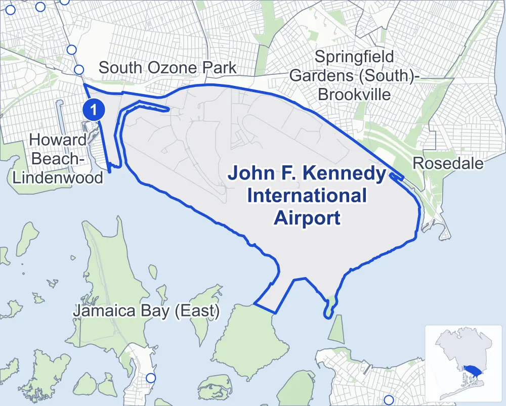
- John F. Kennedy International Airport
- A neighboring area
- Park
- A station in the list
- Another station
Neighborhood areas and streets: NYC Department of City Planning. Parks: NYC Parks. Stations: MTA.
Neighboring areas
- Springfield Gardens (South)-Brookville northeast
- Rosedale east
- Jamaica Bay (East) south
- Howard Beach-Lindenwood west
- South Ozone Park northwest
Subway stations
- Howard Beach-JFK Airport lines A accessible
Getting around
One subway station and buses on 12 routes stop in or at the edge of John F. Kennedy International Airport.
- 1 subway station
- 1 listed by the MTA as fully accessible
- 11 local bus routes
- 1 express bus route
Local bus routes
- B15
- Q3
- Q6
- Q7
- Q10
- Q11
- Q77
- Q80
- Q97
- Q109
- Q121
Express bus route
- QM15
Safety record
Between 2021 and 2025, its corners averaged fewer police-reported crashes than the average Queens corner.
- 5 police-reported crashes at its corners
- 0.0 a corner, on average
- 5.2 the average Queens corner
- 96 corners with a clean record
Camera tickets
In 2025 the Department of Finance recorded no red-light, school-zone speed or bus-lane camera ticket at its corners.
Parks and landmarks
- Parkland
- 21.1 acres of Jamaica Bay Park, as NYC Parks maps it within John F. Kennedy International Airport
- Designated landmark
- The Trans World Airlines Flight Center
Streets and trees
- Trees
- 39 in NYC Parks' records, most often thornless honeylocust, Japanese pagoda tree and pin oak
- Street with the most corners
- Van Wyck Expressway, with 21 of the area's 101
- Height above sea level
- From 8 feet at 130th Place & 155th Avenue to 26 feet at South Cargo Road & JFK Expressway
Street corners
- 130th Place & 30th Place
- 130th Place & 155th Avenue
- 130th Place & Bergen Road
- 130th Place & East Hangar Road
- 130th Place & Pan Am Road
- 130th Place & Van Wyck Expressway
- 130th Street & 155th Avenue
- 130th Street & Pan Am Road
- 134th Street & 150th Avenue
- 134th Street & 155th Avenue
- 134th Street & Bergen Road
- 147th Street & 147th Avenue
- 147th Street & 150th Avenue
- 148th Street & 150th Avenue
- 148th Street & Center Cargo Road
- 148th Street & Compass Road
- 148th Street & JFK Expressway (north)
- 148th Street & JFK Expressway (south)
- 150th Avenue & Van Wyck Expressway
- 150th Street & 148th Street at 147th Avenue
- 150th Street & 148th Street at South Cargo Road
- Bergen Road & Federal Circle
- Bergen Road & Federal Circle at Van Wyck Expressway
- Cargo Plaza & 150th Avenue
- Cargo Plaza & Cargo Service Road
- Cargo Plaza & Center Cargo Road
- Cargo Plaza & North Service Court
- Cargo Plaza & South Service Court
- Cargo Service Road & Federal Circle (north)
- Cargo Service Road & Federal Circle (south)
- Cargo Service Road & Rental Car North
- Commissary Road & West Hangar Road
- Compass Road & North Service Court
- Compass Road & South Cargo Road
- Compass Road & South Service Court
- Eastern Road & North Boundary Road
- Farmers Boulevard & North Boundary Road
- Federal Circle & Van Wyck Expressway (north-east)
- Federal Circle & Van Wyck Expressway (south)
- Federal Circle & Van Wyck Expressway (west)
- JFK Access Road & Cargo Service Road
- JFK Access Road & Commissary Road
- JFK Access Road & General Aviation Way
- JFK Access Road & JFK Terminal 4 Access Road
- JFK Access Road & JFK Terminal 7 Access Road
- JFK Access Road & JFK Terminal 8 Access Road
- JFK Access Road & Van Wyck Expressway
- JFK Terminal 1 Access Road & JFK Terminal Access Road (east)
- JFK Terminal 1 Access Road & JFK Terminal Access Road (west)
- JFK Terminal 1 Arrivals Road & JFK Terminal 1 Access Road (north-west)
- JFK Terminal 1 Arrivals Road & JFK Terminal 1 Access Road (south-east)
- JFK Terminal 1 Departures Road & JFK Terminal 1 Arrivals Road
- JFK Terminal 4 Access Road & JFK Expressway (north-east)
- JFK Terminal 4 Access Road & JFK Expressway (south-west)
- JFK Terminal 4 Access Road & JFK Terminal 1 Access Road
- JFK Terminal 4 Access Road & JFK Terminal 5 Access Road
- JFK Terminal 4 Access Road & JFK Terminal 5 Access Road at JFK Terminal Access Road
- JFK Terminal 5 Access Road & Idlewild Drive (north)
- JFK Terminal 5 Access Road & Idlewild Drive (south)
- JFK Terminal 5 Access Road & JFK Terminal Access Road
- JFK Terminal 8 Access Road & JFK Expressway (east)
- JFK Terminal 8 Access Road & JFK Expressway (west)
- JFK Terminal 8 Access Road & JFK Terminal 5 Access Road
- JFK Terminal 8 Access Road & JFK Terminal 8 Arrivals Road at JFK Terminal 8 Departures Road (north-east)
- JFK Terminal 8 Access Road & JFK Terminal 8 Arrivals Road at JFK Terminal 8 Departures Road (south-west)
- JFK Terminal 8 Access Road & JFK Terminal 8 Departures Road (north-east)
- JFK Terminal 8 Access Road & JFK Terminal 8 Departures Road (south-west)
- JFK Terminal 8 Access Road & Van Wyck Expressway
- John F Kennedy Expressway & 150th Avenue
- John F Kennedy Expressway & JFK Access Road
- John F Kennedy Expressway & JFK Expressway
- John F Kennedy Expressway & JFK Terminal 4 Access Road (north)
- John F Kennedy Expressway & JFK Terminal 4 Access Road (south)
- John F Kennedy Expressway & JFK Terminal 5 Access Road
- John F Kennedy Expressway & JFK Terminal 8 Access Road
- John F Kennedy Expressway & JFK Terminal Access Road
- John F Kennedy Expressway & South Cargo Road
- John F Kennedy Expressway & Van Wyck Expressway
- Lefferts Boulevard & Pan Am Road
- North Boundary Road & 150th Avenue
- North Boundary Road & Old Rockaway Boulevard
- North Hangar Road & North Boundary Road
- North Service Court & Pilot Road
- North Service Road & Federal Circle
- North Service Road & Van Wyck Expressway
- South Cargo Road & JFK Expressway (north-east)
- South Cargo Road & JFK Expressway (south-west)
- South Service Road & General Aviation Way
- South Service Road & Van Wyck Expressway (N Service Road)
- South Service Road & Van Wyck Expressway (S Service Road)
- Van Wyck Expressway & Federal Circle (north)
- Van Wyck Expressway & Federal Circle (south)
- Van Wyck Expressway & JFK Access Road (east)
- Van Wyck Expressway & JFK Access Road (west)
- Van Wyck Expressway & JFK Access Road at JFK Terminal Access Road
- Van Wyck Expressway & JFK Terminal 1-2-3 Access Road (east)
- Van Wyck Expressway & JFK Terminal 1-2-3 Access Road (west)
- Van Wyck Expressway & Pedestrian Overpass (north-west)
- Van Wyck Expressway & Pedestrian Overpass (south-east)
- West Hangar Road & 30th Place
- West Hangar Road & 130th Place
How the figures above are measured: Methodology.