Springfield Gardens (South)-Brookville
Neighborhood · Queens
Along the northern edge of Kennedy Airport, this strip of southeast Queens takes in the southern part of Springfield Gardens and the Brookville section east of Springfield Boulevard.
- 2.06 square miles
- 23,103 residents, 2020 Census
- 336 street corners
- 10 bus routes
Europeans settled the area in 1660 and farmed it for generations; it grew quickly in the 1920s as newcomers arrived from Brooklyn, and in 1927 it became known as Springfield Gardens. Springfield Park was built by the Works Progress Administration in 1939 around a three-acre lake that had been a swamp, with ball fields nearby, and the tidal marshes of Idlewild Park lie along the area's southern edge.
Sources: Springfield Gardens, Queens (Wikipedia); Springfield Park – Jamaica NY (The Living New Deal); Idlewild Park Preserve (Eastern Queens Alliance presentation) (Science and Resilience Institute at Jamaica Bay).
Springfield Gardens (South)-Brookville borders six areas, and South Conduit Avenue holds more of its corners than any other street, 42 of 336.
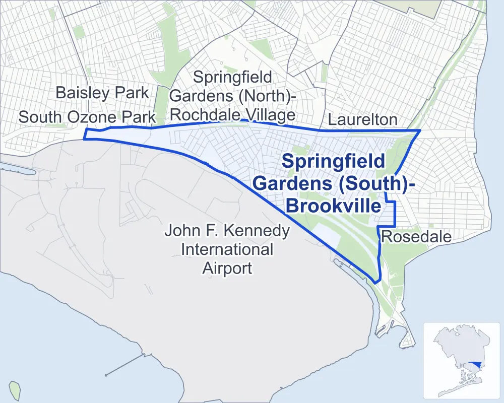
- Springfield Gardens (South)-Brookville
- A neighboring area
- Park
Neighborhood areas and streets: NYC Department of City Planning. Parks: NYC Parks. Stations: MTA.
Neighboring areas
- Laurelton northeast
- Rosedale southeast
- John F. Kennedy International Airport west
- Baisley Park west
- South Ozone Park west
- Springfield Gardens (North)-Rochdale Village northwest
Getting around
Buses on ten routes stop in or at the edge of Springfield Gardens (South)-Brookville.
- 10 local bus routes
Local bus routes
- Q3
- Q6
- Q77
- Q85
- Q86
- Q89
- Q111
- Q113
- Q114
- Q115
Safety record
Between 2021 and 2025, its corners averaged more police-reported crashes than the average Queens corner.
- 2,380 police-reported crashes at its corners
- 7.1 a corner, on average
- 5.2 the average Queens corner
- 63 corners with a clean record
Signal or safety changes on City record, at 15 of its corners
- Accessible pedestrian signals
- 12
- Leading pedestrian intervals
- 7
- Turn calming
- 1
- Safety Improvement Projects
- 1
Camera tickets
In 2025 its corners had more school-zone speed camera tickets than red-light or bus-lane tickets.
- 12,541 red-light camera tickets at seven corners
- 24,496 school-zone speed camera tickets at eight corners
- 0 bus-lane camera tickets
- Most red-light tickets
- South Conduit Avenue & Farmers Boulevard, 3,293
- Most speed tickets
- Springfield Boulevard & South Conduit Avenue, 8,727
People and homes
The 2020 Census counted 23,103 residents in Springfield Gardens (South)-Brookville, about 11,200 per square mile.
- 7,049 homes, 2020 Census
- 369 homes added since April 2010, net, by City Planning's count
Half of its 3,916 residential lots hold buildings from 1950 or earlier, and 24% of them date from before 1940, by the City's tax lot records.
Parks
- Parkland
- 276.5 acres of NYC Parks property
- The largest pieces
- Idlewild Park (160.8 acres), Brookville Park (88.8 acres) and Springfield Park (25.8 acres)
Streets and trees
- Trees
- 5,316 in NYC Parks' records, most often Japanese flowering cherry, thornless honeylocust and pin oak
- Street with the most corners
- South Conduit Avenue, with 42 of the area's 336
- Height above sea level
- From 4 feet at 236th Street & Bentley Road to 30 feet at 150th Street & Belt Parkway
- Honorary street name
- 1 at its corners, enacted by local law
Schools
The City lists six schools in Springfield Gardens (South)-Brookville.
- Public schools
- 5
- Charter or private school
- 1
Public safety
How complaints are countedIn 2025 the NYPD recorded 232 major felonies at places in Springfield Gardens (South)-Brookville.
Recorded by the NYPD at places in Springfield Gardens (South)-Brookville
- 221 major felonies in 2024
- 1,094 other felonies, misdemeanors and violations in 2025
In 2025, on the streets along the edge of Springfield Gardens (South)-Brookville, the NYPD recorded another 17 major felonies. Counting the streets along its edge, in 2025 the NYPD recorded 10.8 major felonies for every thousand residents the 2020 Census counted in Springfield Gardens (South)-Brookville.
- Police precincts
- 116th (most of the area), 113th
From January to June 2026 the NYPD recorded 91 major felonies at places in Springfield Gardens (South)-Brookville, against 116 in the same months of 2025.
Sources: the NYPD's Complaint Data Historic, updated April 28, 2026, and Complaint Data Current (Year To Date), updated July 27, 2026, on NYC Open Data. Figures to June 30, 2026.
Street corners
- 144th Avenue & 230th Place
- 144th Avenue & Edgewood Avenue
- 145th Avenue & 176th Street
- 145th Avenue & 177th Place
- 145th Avenue & 177th Street
- 145th Avenue & 178th Place
- 145th Avenue & 179th Street
- 145th Avenue & 181st Street
- 145th Avenue & 230th Place
- 145th Avenue & Arthur Street
- 145th Drive & 177th Place
- 145th Road & 178th Place
- 145th Road & Arthur Street
- 146th Avenue & 153rd Court
- 146th Avenue & 153rd Lane
- 146th Avenue & 230th Place
- 147th Avenue & 176th Street
- 147th Avenue & 177th Street
- 147th Avenue & 181st Street
- 147th Avenue & 182nd Street
- 147th Avenue & 183rd Street
- 147th Avenue & 184th Street
- 147th Avenue & 230th Place
- 147th Avenue & 235th Street
- 147th Avenue & Springfield Lane
- 148th Avenue & 230th Place
- 148th Avenue & 235th Street
- 149th Avenue & 182nd Street
- 149th Avenue & 183rd Street
- 149th Avenue & 184th Street
- 149th Avenue & 230th Place
- 149th Avenue & 241st Street
- 149th Avenue & Springfield Lane
- 150th Street & Belt Parkway
- 155th Street & 145th Avenue
- 155th Street & 145th Drive
- 155th Street & 146th Avenue
- 156th Street & 145th Avenue
- 156th Street & 146th Avenue
- 157th Street & 145th Avenue
- 157th Street & 145th Road
- 157th Street & 146th Avenue
- 158th Street & 145th Road
- 158th Street & 146th Avenue
- 159th Street & 145th Road
- 166th Street & 144th Avenue
- 166th Street & 144th Drive
- 166th Street & 144th Road
- 167th Street & 144th Avenue
- 167th Street & 144th Drive
- 167th Street & 144th Terrace
- 167th Street & 145th Avenue
- 167th Street & 145th Drive
- 167th Street & 145th Road
- 167th Street & 146th Avenue
- 167th Street & 146th Road
- 167th Street & 147th Avenue
- 168th Street & 144th Avenue
- 168th Street & 144th Drive
- 168th Street & 146th Avenue
- 168th Street & 146th Road
- 175th Street & 144th Drive
- 175th Street & 144th Terrace
- 175th Street & 145th Avenue
- 175th Street & 145th Drive
- 175th Street & 145th Road
- 175th Street & 146th Avenue
- 175th Street & 146th Road
- 175th Street & 148th Avenue
- 175th Street & 148th Road
- 175th Street & Porter Road
- 176th Street & 144th Drive
- 176th Street & 145th Drive
- 176th Street & 148th Avenue
- 177th Street & 145th Drive
- 177th Street & 146th Drive
- 177th Street & 148th Avenue
- 177th Street & 149th Road
- 178th Place & 145th Drive
- 178th Place & 146th Road
- 179th Street & 145th Drive
- 179th Street & 145th Road
- 179th Street & 146th Road
- 180th Street & 145th Avenue
- 180th Street & 145th Drive
- 180th Street & 145th Road
- 181st Street & 145th Drive
- 181st Street & 145th Road
- 181st Street & 146th Avenue
- 181st Street & 146th Drive
- 181st Street & 146th Road
- 181st Street & 146th Terrace
- 182nd Street & 145th Avenue
- 182nd Street & 145th Drive
- 182nd Street & 145th Road
- 182nd Street & 146th Avenue
- 182nd Street & 146th Drive
- 182nd Street & 146th Road
- 182nd Street & 146th Terrace
- 182nd Street & 149th Road
- 182nd Street & 150th Avenue
- 182nd Street & 150th Drive
- 182nd Street & 150th Road
- 183rd Street & 145th Avenue
- 183rd Street & 145th Drive
- 183rd Street & 145th Road
- 183rd Street & 146th Road
- 183rd Street & 146th Terrace
- 183rd Street & 149th Road
- 183rd Street & 150th Avenue
- 183rd Street & 150th Drive
- 183rd Street & 150th Road
- 184th Street & 144th Road
- 184th Street & 145th Avenue
- 184th Street & 145th Road
- 184th Street & 146th Road
- 184th Street & 146th Terrace
- 220th Street & 145th Avenue
- 220th Street & 145th Road
- 220th Street & 146th Avenue
- 220th Street & Springfield Lane
- 221st Street & 145th Avenue
- 221st Street & 145th Road
- 221st Street & 146th Avenue
- 221st Street & Springfield Lane
- 222nd Street & 145th Avenue
- 222nd Street & 145th Road
- 222nd Street & 146th Avenue
- 222nd Street & 147th Avenue
- 223rd Street & 144th Avenue
- 223rd Street & 145th Avenue
- 223rd Street & 145th Road
- 223rd Street & 146th Avenue
- 223rd Street & 147th Avenue
- 223rd Street & 149th Avenue
- 224th Street & 144th Avenue
- 224th Street & 145th Avenue
- 224th Street & 145th Road
- 224th Street & 146th Avenue
- 224th Street & 147th Avenue
- 224th Street & 149th Avenue
- 225th Street & 144th Avenue
- 225th Street & 145th Avenue
- 225th Street & 145th Road
- 225th Street & 146th Avenue
- 225th Street & 147th Avenue
- 225th Street & 148th Avenue
- 226th Street & 144th Avenue
- 226th Street & 145th Avenue
- 226th Street & 145th Road
- 226th Street & 146th Avenue
- 226th Street & 147th Avenue
- 226th Street & 148th Avenue
- 227th Street & 144th Avenue
- 227th Street & 145th Avenue
- 227th Street & 145th Road
- 227th Street & 146th Avenue
- 227th Street & 147th Avenue
- 227th Street & 148th Avenue
- 228th Street & 144th Avenue
- 228th Street & 145th Avenue
- 228th Street & 145th Road
- 228th Street & 146th Avenue (north-east)
- 228th Street & 146th Avenue (south-west)
- 228th Street & 147th Avenue
- 228th Street & 148th Avenue
- 229th Street & 144th Avenue
- 229th Street & 145th Avenue
- 229th Street & 146th Avenue
- 229th Street & 147th Avenue
- 229th Street & 148th Avenue
- 229th Street & Edgewood Avenue
- 230th Place & Edgewood Avenue
- 230th Place & Lansing Avenue
- 230th Street & 144th Avenue
- 230th Street & 145th Avenue
- 230th Street & 146th Avenue
- 230th Street & 147th Avenue
- 230th Street & 148th Avenue
- 230th Street & 149th Avenue
- 230th Street & Edgewood Avenue
- 231st Street & 144th Avenue
- 231st Street & 145th Avenue
- 231st Street & 146th Avenue
- 231st Street & 147th Avenue
- 231st Street & 148th Avenue
- 231st Street & Edgewood Avenue
- 231st Street & Lansing Avenue
- 232nd Street & 143rd Avenue
- 232nd Street & 144th Avenue
- 232nd Street & 145th Avenue
- 232nd Street & 146th Avenue
- 232nd Street & 147th Avenue
- 232nd Street & Edgewood Avenue
- 232nd Street & Lansing Avenue
- 235th Street & 147th Drive
- 235th Street & 147th Road
- 236th Street & Bentley Road
- 241st Street & 147th Road
- 241st Street & 148th Avenue
- Belt Parkway & 150th Street
- Belt Parkway & 225th Street
- Belt Parkway & Farmers Boulevard
- Belt Parkway & Guy R Brewer Boulevard
- Belt Parkway & Nassau Expressway
- Belt Parkway & Springfield Boulevard
- Belt Parkway & Sunrise Highway
- Belt Parkway & Van Wyck Expressway
- Broadway & Meadow Drive
- Broadway & Meadow Road
- Brookville Boulevard & 141st Avenue
- Brookville Boulevard & 143rd Avenue
- Brookville Boulevard & 145th Avenue
- Brookville Boulevard & 147th Drive
- Brookville Boulevard & 148th Avenue
- Brookville Boulevard & 148th Drive
- Brookville Boulevard & 148th Road
- Brookville Boulevard & 149th Avenue
- Brookville Boulevard & Bentley Road
- Brookville Boulevard & Edgewood Avenue
- Brookville Boulevard & Mayda Road
- Eastern Road & International Airport Center Boulevard
- Farmers Boulevard & 145th Avenue
- Farmers Boulevard & 145th Drive
- Farmers Boulevard & 145th Road
- Farmers Boulevard & 175th Street
- Farmers Boulevard & 175th Street at 147th Avenue
- Farmers Boulevard & 176th Street
- Farmers Boulevard & 177th Place
- Farmers Boulevard & 177th Street
- Guy R Brewer Boulevard & 145th Avenue
- Guy R Brewer Boulevard & 145th Drive
- Guy R Brewer Boulevard & 145th Road
- Guy R Brewer Boulevard & 146th Drive
- Guy R Brewer Boulevard & 146th Road
- Guy R Brewer Boulevard & 146th Terrace
- Guy R Brewer Boulevard & 147th Avenue
- Guy R Brewer Boulevard & 148th Avenue
- Guy R Brewer Boulevard & 148th Road
- Guy R Brewer Boulevard & 149th Avenue
- Guy R Brewer Boulevard & 149th Road
- Guy R Brewer Boulevard & 150th Avenue
- Guy R Brewer Boulevard & Farmers Boulevard
- Guy R Brewer Boulevard & Meadow Road
- John F Kennedy Expressway & Belt Parkway
- John F Kennedy Expressway & Belt Parkway at JFK Expressway
- John F Kennedy Expressway & South Conduit Avenue
- Nassau Expressway & JFK Expressway (north-west)
- Nassau Expressway & JFK Expressway (south-east)
- Nassau Expressway & JFK Expressway (south-west)
- Nassau Expressway & John F Kennedy Expressway (north-east)
- Nassau Expressway & John F Kennedy Expressway (south-west)
- Nassau Expressway & North Conduit Avenue
- Nassau Expressway & North Hangar Road
- Nassau Expressway & Rockaway Boulevard
- Nassau Expressway & Rockaway Boulevard at Farmers Boulevard
- Nassau Expressway & South Conduit Avenue
- Nassau Expressway & Van Wyck Expressway
- Nassau Expressway & Van Wyck Expressway at South Conduit Avenue
- North Conduit Avenue & 135th Avenue
- North Conduit Avenue & 135th Avenue at Baisley Boulevard
- North Conduit Avenue & 136th Avenue
- North Conduit Avenue & 142nd Street
- North Conduit Avenue & 143rd Road
- North Conduit Avenue & 149th Street
- North Conduit Avenue & 155th Street
- North Conduit Avenue & 158th Street
- North Conduit Avenue & 160th Street
- North Conduit Avenue & 181st Street
- North Conduit Avenue & 224th Street
- North Conduit Avenue & 230th Place
- North Conduit Avenue & Belt Parkway
- North Conduit Avenue & Belt Parkway (Exit 21)
- North Conduit Avenue & Belt Parkway (Exit 22)
- North Conduit Avenue & Farmers Boulevard
- North Conduit Avenue & Guy R Brewer Boulevard
- North Conduit Avenue & Inwood Street
- North Conduit Avenue & Latham Lane
- North Conduit Avenue & Rockaway Boulevard
- North Conduit Avenue & Van Wyck Expressway
- Rockaway Boulevard & 144th Road
- Rockaway Boulevard & 145th Drive
- Rockaway Boulevard & 146th Avenue
- Rockaway Boulevard & 146th Road
- Rockaway Boulevard & 147th Avenue
- Rockaway Boulevard & 157th Street
- Rockaway Boulevard & 158th Street
- Rockaway Boulevard & 159th Street
- Rockaway Boulevard & Belt Parkway
- Rockaway Boulevard & Guy R Brewer Boulevard
- Rockaway Boulevard & South Conduit Avenue
- South Conduit Avenue & 144th Avenue
- South Conduit Avenue & 153rd Court
- South Conduit Avenue & 153rd Lane
- South Conduit Avenue & 155th Street
- South Conduit Avenue & 156th Street
- South Conduit Avenue & 166th Street
- South Conduit Avenue & 167th Street
- South Conduit Avenue & 168th Street
- South Conduit Avenue & 175th Street
- South Conduit Avenue & 176th Street
- South Conduit Avenue & 177th Place
- South Conduit Avenue & 177th Street
- South Conduit Avenue & 179th Street
- South Conduit Avenue & 180th Street
- South Conduit Avenue & 181st Street
- South Conduit Avenue & 182nd Street
- South Conduit Avenue & 183rd Street
- South Conduit Avenue & 184th Street
- South Conduit Avenue & 221st Street
- South Conduit Avenue & 222nd Street
- South Conduit Avenue & 223rd Street
- South Conduit Avenue & 224th Street
- South Conduit Avenue & 225th Street
- South Conduit Avenue & 226th Street
- South Conduit Avenue & 230th Place
- South Conduit Avenue & 231st Street
- South Conduit Avenue & 232nd Street
- South Conduit Avenue & Belt Parkway
- South Conduit Avenue & Belt Parkway at 153rd Place
- South Conduit Avenue & Brookville Boulevard
- South Conduit Avenue & Edgewood Avenue
- South Conduit Avenue & Farmers Boulevard
- South Conduit Avenue & Guy R Brewer Boulevard
- South Conduit Avenue & Lansing Avenue
- South Conduit Avenue & Van Wyck Expressway
- Springfield Boulevard & 145th Road
- Springfield Boulevard & 146th Avenue
- Springfield Boulevard & 147th Avenue
- Springfield Boulevard & South Conduit Avenue
- Springfield Lane & Johnson Lane
- Sunrise Highway & Belt Parkway
- Van Wyck Expressway & Belt Parkway
- Van Wyck Expressway & Nassau Expressway
- Van Wyck Expressway & North Conduit Avenue
- Van Wyck Expressway & South Conduit Avenue
How the figures above are measured: Methodology.