Long Island City-Hunters Point
Neighborhood · Queens
Long Island City-Hunters Point lies on the East River across from Midtown Manhattan, with Newtown Creek along its southern edge.
- 0.99 square miles
- 32,216 residents, 2020 Census
- 212 street corners
- 6 subway stations
- 19 bus routes
The point took the name Hunters Point in 1825, after British sea captain George Hunter, whose family farmed the land, and in 1870 it joined Astoria and neighboring hamlets to form the city of Long Island City, part of New York City since 1898. Late 19th-century town houses on 45th Avenue make up the Hunters Point Historic District, designated in 1968, and restored rail-car float gantries stand in Gantry Plaza State Park, opened in 1998.
Sources: Hunters Point Historic District, Borough of Queens (designation report, May 15, 1968) (NYC Landmarks Preservation Commission); Long Island City (Wikipedia); Gantry Plaza State Park (New York State Parks); Gantry Plaza State Park (Wikipedia).
Long Island City-Hunters Point borders three areas, and Jackson Avenue holds more of its corners than any other street, 26 of 212.
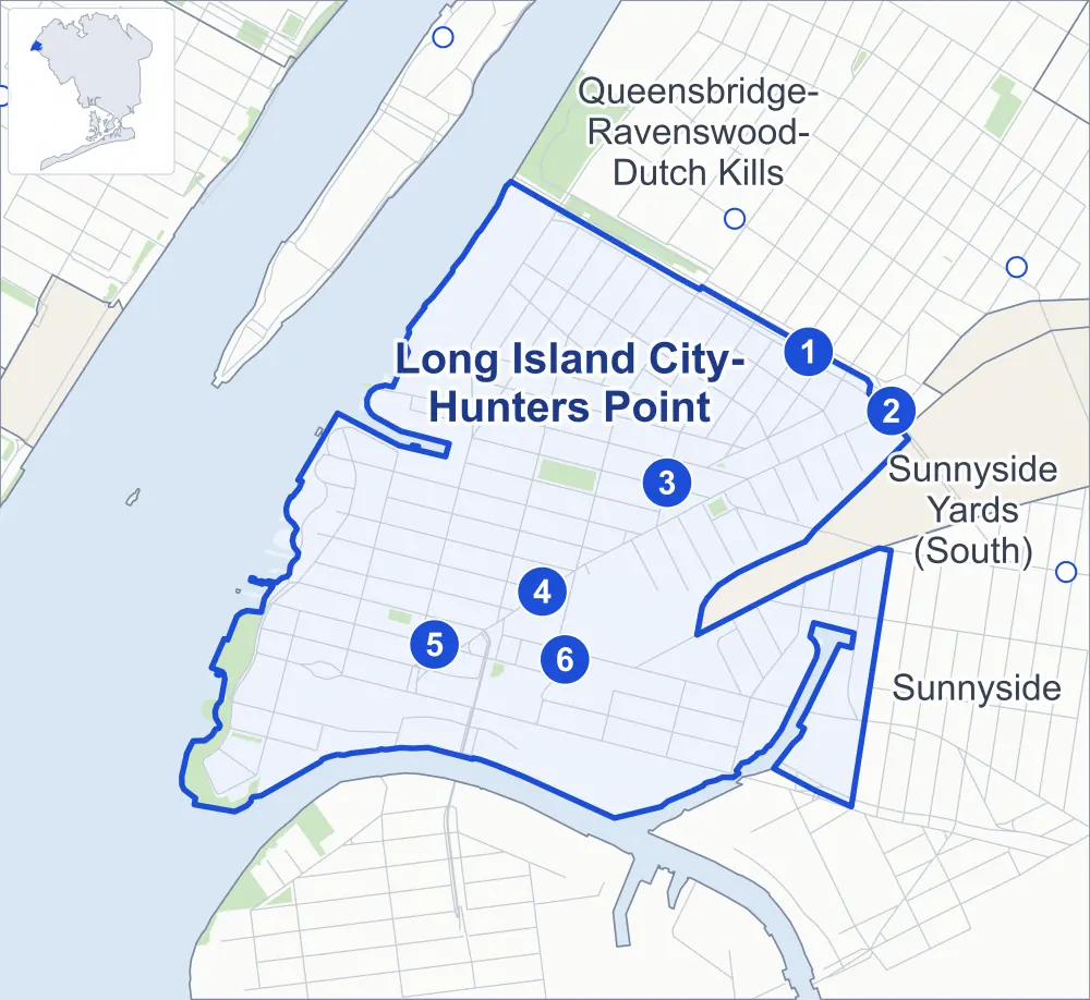
- Long Island City-Hunters Point
- A neighboring area
- Park
- A station in the list
- Another station
Neighborhood areas and streets: NYC Department of City Planning. Parks: NYC Parks. Stations: MTA.
Neighboring areas
- Queensbridge-Ravenswood-Dutch Kills northeast
- Sunnyside Yards (South) east
- Sunnyside southeast
Subway stations
- Queensboro Plaza lines 7 N W accessible
- Queens Plaza lines E F R accessible
- Court Sq / Court Sq-23 St lines 7 E F G
- 21 St lines G
- Vernon Blvd-Jackson Av lines 7
- Hunters Point Av lines 7
Getting around
Six subway stations and buses on 19 routes stop in or at the edge of Long Island City-Hunters Point.
- 6 subway stations
- 2 of them listed by the MTA as fully accessible
- 19 local bus routes
Local bus routes
- B32
- B62
- B94
- Q32
- Q39
- Q60
- Q63
- Q66
- Q67
- Q69
- Q96
- Q100
- Q101
- Q102
- Q103
- Q108
- T320
- T323
- T403
Safety record
Between 2021 and 2025, its corners averaged more police-reported crashes than the average Queens corner.
- 1,573 police-reported crashes at its corners
- 7.4 a corner, on average
- 5.2 the average Queens corner
- 29 corners with a clean record
Signal or safety changes on City record, at 29 of its corners
- Leading pedestrian intervals
- 19
- Accessible pedestrian signals
- 14
- Turn calming
- 4
- Safety Improvement Projects
- 4
- Enhanced crossings
- 1
Camera tickets
In 2025 its corners had more school-zone speed camera tickets than red-light or bus-lane tickets.
- 0 red-light camera tickets
- 445 school-zone speed camera tickets at two corners
- 0 bus-lane camera tickets
- Most speed tickets
- 44th Avenue & 11th Street, 421
People and homes
The 2020 Census counted 32,216 residents in Long Island City-Hunters Point, about 32,500 per square mile.
- 19,084 homes, 2020 Census
- 23,092 homes added since April 2010, net, by City Planning's count
Half of its 663 residential lots hold buildings from 1931 or earlier, and 66% of them date from before 1940, by the City's tax lot records.
Parks and landmarks
- Parkland
- 16.7 acres of NYC Parks property
- The largest pieces
- Hunter's Point South Park (12.1 acres), Murray Playground (2.5 acres) and Andrews Grove (0.5 acre)
- Designated landmarks
- The Fire Engine Company 258, Hook and Ladder Company 115; the Long Island City Courthouse; the New York Architectural Terra Cotta Works; and the Pepsi-Cola Sign
- Historic district
- Hunters Point Historic District, wholly or partly within Long Island City-Hunters Point
Streets and trees
- Trees
- 2,476 in NYC Parks' records, most often thornless honeylocust, Japanese zelkova and Callery pear
- Street with the most corners
- Jackson Avenue, with 26 of the area's 212
- Height above sea level
- From 4 feet at 54th Avenue & 2nd Street to 32 feet at Skillman Avenue & Thomson Avenue
- Honorary street names
- 14 at its corners, enacted by local law
Schools and libraries
The City lists eight schools and one library in Long Island City-Hunters Point.
- Public schools
- 6
- Charter and private schools
- 2
- Library
- Hunters Point Library
Bike share and public art
By the station list of October 3, 2026, 26 bike-share stations stand in Long Island City-Hunters Point. The City's public art inventory lists four works in the area, among them Capt. Malcolm A. Rafferty (1937), Tetherball Monument (2015) and Sunbather (2016).
- 26 bike-share stations
- 4 works of public art
Public safety
How complaints are countedIn 2025 the NYPD recorded 527 major felonies at places in Long Island City-Hunters Point.
Recorded by the NYPD at places in Long Island City-Hunters Point
- 463 major felonies in 2024
- 1,454 other felonies, misdemeanors and violations in 2025
In 2025, on the streets along the edge of Long Island City-Hunters Point, the NYPD recorded another nine major felonies. Counting the streets along its edge, in 2025 the NYPD recorded 16.6 major felonies for every thousand residents the 2020 Census counted in Long Island City-Hunters Point.
- Police precinct
- 108th
From January to June 2026 the NYPD recorded 274 major felonies at places in Long Island City-Hunters Point, against 228 in the same months of 2025.
Sources: the NYPD's Complaint Data Historic, updated April 28, 2026, and Complaint Data Current (Year To Date), updated July 27, 2026, on NYC Open Data. Figures to June 30, 2026.
Street corners
- 9th Street & 43rd Road
- 9th Street & 44th Road
- 9th Street & Queens Plaza South
- 10th Street & 43rd Road
- 10th Street & 44th Drive
- 10th Street & 44th Road
- 10th Street & Queens Plaza South
- 11th Street & 43rd Road
- 11th Street & 44th Drive
- 11th Street & 44th Road
- 11th Street & 45th Road
- 11th Street & 46th Road
- 11th Street & 47th Road
- 11th Street & Jackson Avenue
- 11th Street & Queens Plaza South
- 12th Street & 43rd Road
- 12th Street & Queens Plaza South
- 13th Street & Queens Plaza South
- 21st Street & 44th Avenue
- 21st Street & 44th Drive
- 21st Street & 44th Road
- 21st Street & 45th Road
- 21st Street & 46th Road
- 21st Street & 47th Road
- 21st Street & 49th Avenue
- 21st Street & 51st Avenue Footbridge
- 21st Street & Jackson Avenue
- 21st Street & Queens Plaza South
- 22nd Street & Queens Plaza South
- 23rd Street & 42nd Road
- 23rd Street & 44th Avenue
- 23rd Street & 44th Drive
- 23rd Street & 44th Road
- 23rd Street & 45th Road
- 23rd Street & Jackson Avenue
- 23rd Street & Queens Plaza South
- 24th Street & 42nd Road
- 24th Street & 44th Road
- 24th Street & Queens Plaza South
- 27th Street & 42nd Road
- 27th Street & 49th Avenue
- 27th Street & Austell Place
- 27th Street & Pearson Place
- 27th Street & Queens Plaza
- 27th Street & Queens Plaza South
- 28th Street & Hunter Street
- 28th Street & Queens Plaza
- 28th Street & Queens Plaza South
- 28th Street & Skillman Avenue
- 29th Street & Hunters Point Avenue
- 43rd Avenue & 9th Street
- 43rd Avenue & 10th Street
- 43rd Avenue & 11th Street
- 43rd Avenue & 12th Street
- 43rd Avenue & 13th Street
- 43rd Avenue & 21st Street
- 43rd Avenue & 22nd Street
- 43rd Avenue & 23rd Street
- 43rd Avenue & 24th Street
- 43rd Avenue & 27th Street
- 43rd Avenue & Crescent Street
- 43rd Avenue & Jackson Avenue
- 43rd Avenue & Vernon Boulevard
- 44th Avenue & 9th Street
- 44th Avenue & 10th Street
- 44th Avenue & 11th Street
- 44th Avenue & 12th Street
- 44th Avenue & 13th Street
- 44th Avenue & 22nd Street
- 44th Drive & 5th Street
- 44th Drive & Hunter Street
- 44th Road & Hunter Street
- 45th Avenue & 11th Street
- 45th Avenue & 21st Street
- 45th Avenue & 23rd Street
- 45th Avenue & Jackson Avenue
- 45th Avenue & Vernon Boulevard
- 45th Avenue & Vernon Boulevard at 10th Street
- 46th Avenue & 5th Street
- 46th Avenue & 11th Street
- 46th Avenue & 21st Street
- 46th Avenue & Center Boulevard
- 46th Avenue & Jackson Avenue
- 46th Avenue & Vernon Boulevard
- 46th Road & 5th Street
- 46th Road & Jackson Avenue
- 47th Avenue & 5th Street
- 47th Avenue & 11th Street
- 47th Avenue & 27th Street
- 47th Avenue & 28th Street
- 47th Avenue & 29th Street
- 47th Avenue & Center Boulevard
- 47th Avenue & Jackson Avenue
- 47th Avenue & Vernon Boulevard
- 47th Road & 5th Street
- 48th Avenue & 5th Street
- 48th Avenue & 11th Street
- 48th Avenue & Center Boulevard
- 48th Avenue & Jackson Avenue
- 48th Avenue & Vernon Boulevard
- 49th Avenue & 5th Street
- 49th Avenue & 11th Place
- 49th Avenue & 25th Street
- 49th Avenue & Center Boulevard
- 49th Avenue & Davis Court
- 49th Avenue & Skillman Avenue
- 50th Avenue & 2nd Street
- 50th Avenue & 5th Street
- 50th Avenue & 11th Place
- 50th Avenue & 11th Street
- 50th Avenue & 21st Street
- 50th Avenue & 25th Street
- 50th Avenue & 27th Street
- 50th Avenue & Center Boulevard
- 50th Avenue & Jackson Avenue
- 50th Avenue & Long Island Expressway
- 50th Avenue & Vernon Boulevard
- 51st Avenue & 2nd Street
- 51st Avenue & 5th Street
- 51st Avenue & 11th Street
- 51st Avenue & 21st Street
- 51st Avenue & 23rd Street
- 51st Avenue & 25th Street
- 51st Avenue & 27th Street
- 51st Avenue & Center Boulevard
- 51st Avenue & Jackson Avenue
- 51st Avenue & Vernon Boulevard
- 53rd Avenue & 11th Street
- 53rd Avenue & Vernon Boulevard
- 54th Avenue & 2nd Street
- 54th Avenue & Center Boulevard
- 54th Avenue & Malt Drive
- 54th Avenue & Vernon Boulevard
- 55th Avenue & 2nd Street
- 55th Avenue & Center Boulevard
- 56th Avenue & 2nd Street
- 56th Avenue & Center Boulevard
- Borden Avenue & 11th Street
- Borden Avenue & 21st Street
- Borden Avenue & 23rd Street
- Borden Avenue & 25th Street
- Borden Avenue & 27th Street
- Borden Avenue & 30th Street
- Borden Avenue & Center Boulevard
- Borden Avenue & I 495
- Borden Avenue & Vernon Boulevard
- Borden Avenue Bridge & Borden Avenue
- Center Boulevard & 47th Road
- Court Square West & Court Square
- Crescent Street & 42nd Road
- Crescent Street & 44th Road
- Crescent Street & Hunter Street
- Crescent Street & Queens Plaza South
- Davis Court & Pearson Place
- Ed Koch Bridge & Ed Koch Queensboro Bridge Pedestrian Path
- Ed Koch Bridge Upper Roadway & 13th Street
- Ed Koch Bridge Upper Roadway & 21st Street
- Ed Koch Bridge Upper Roadway & Jackson Avenue (north-east)
- Ed Koch Bridge Upper Roadway & Jackson Avenue (south-west)
- Ed Koch Bridge Upper Roadway & Queensboro Bridge
- Ed Koch Bridge Upper Roadway & Thomson Avenue
- Hunters Point Bridge & Hunters Point Avenue
- Jackson Avenue & 42nd Road
- Jackson Avenue & 44th Drive
- Jackson Avenue & 47th Road
- Jackson Avenue & Arch Street
- Jackson Avenue & Crane Street
- Jackson Avenue & Orchard Street
- Jackson Avenue & Purves Street
- Jackson Avenue & Queens Plaza South
- Jackson Avenue & Queens Street
- Jackson Avenue & Thomson Avenue
- Long Island Expressway & 23rd Street
- Long Island Expressway & 25th Street
- Long Island Expressway & 27th Street
- Long Island Expressway & 30th Street
- Long Island Expressway & 51st Avenue Footbridge
- Long Island Expressway & Borden Avenue
- Long Island Expressway & Pulaski Bridge
- Long Island Expressway & Pulaski Bridge Bike Path
- Long Island Expressway & Pulaski Bridge Pedestrian Path
- Pulaski Bridge & 11th Street
- Pulaski Bridge & 49th Avenue at 11th Street
- Pulaski Bridge & 49th Avenue at Jackson Avenue
- Pulaski Bridge & 50th Avenue
- Pulaski Bridge & 53rd Avenue
- Pulaski Bridge & Borden Avenue
- Queens Boulevard & Jackson Avenue
- Queens Midtown Tunnel & Borden Avenue (east)
- Queens Midtown Tunnel & Borden Avenue (west)
- Queens Midtown Tunnel & Borden Avenue at 2nd Street
- Queens Midtown Tunnel & Borden Avenue at 5th Street
- Queens Midtown Tunnel & Center Boulevard
- Queens Midtown Tunnel & Long Island Expressway
- Queens Midtown Tunnel & Vernon Boulevard
- Queens Plaza South & Ed Koch Bridge Upper Roadway
- Queens Plaza South & Ed Koch Queensboro Bridge Pedestrian Path
- Queensboro Bridge & 22nd Street
- Queensboro Bridge & Ed Koch Bridge
- Skillman Avenue & Thomson Avenue
- Thomson Avenue & 44th Drive
- Thomson Avenue & Court Square
- Vernon Boulevard & 43rd Road
- Vernon Boulevard & 44th Avenue
- Vernon Boulevard & 44th Drive
- Vernon Boulevard & 44th Road
- Vernon Boulevard & 45th Road
- Vernon Boulevard & 46th Road
- Vernon Boulevard & 47th Road
- Vernon Boulevard & 49th Avenue
- Vernon Boulevard & Jackson Avenue
- Vernon Boulevard & Queens Plaza South
How the figures above are measured: Methodology.