Bellerose
Neighborhood · Queens
Bellerose sits on the eastern edge of Queens, a neighborhood of mostly detached houses that Jericho Turnpike divides from the Nassau County village whose name it shares.
- 1.98 square miles
- 26,566 residents, 2020 Census
- 284 street corners
- 11 bus routes
Within its borders lies the Queens County Farm Museum, 47 acres that form the city's largest remaining tract of undisturbed farmland. The land has been farmed since 1697, making it one of the longest continuously worked farm sites in New York State, and its 18th-century farmhouse, later enlarged, is a designated city landmark.
Sources: Bellerose, Queens (Wikipedia); Creedmoor (Cornell) Farmhouse Designation Report (LP-0941, November 9, 1976) (NYC Landmarks Preservation Commission); Queens County Farm Museum - Home (Queens County Farm Museum); Queens County Farm Museum (Wikipedia).
Bellerose borders five areas, and Hillside Avenue holds more of its corners than any other street, 33 of 284.
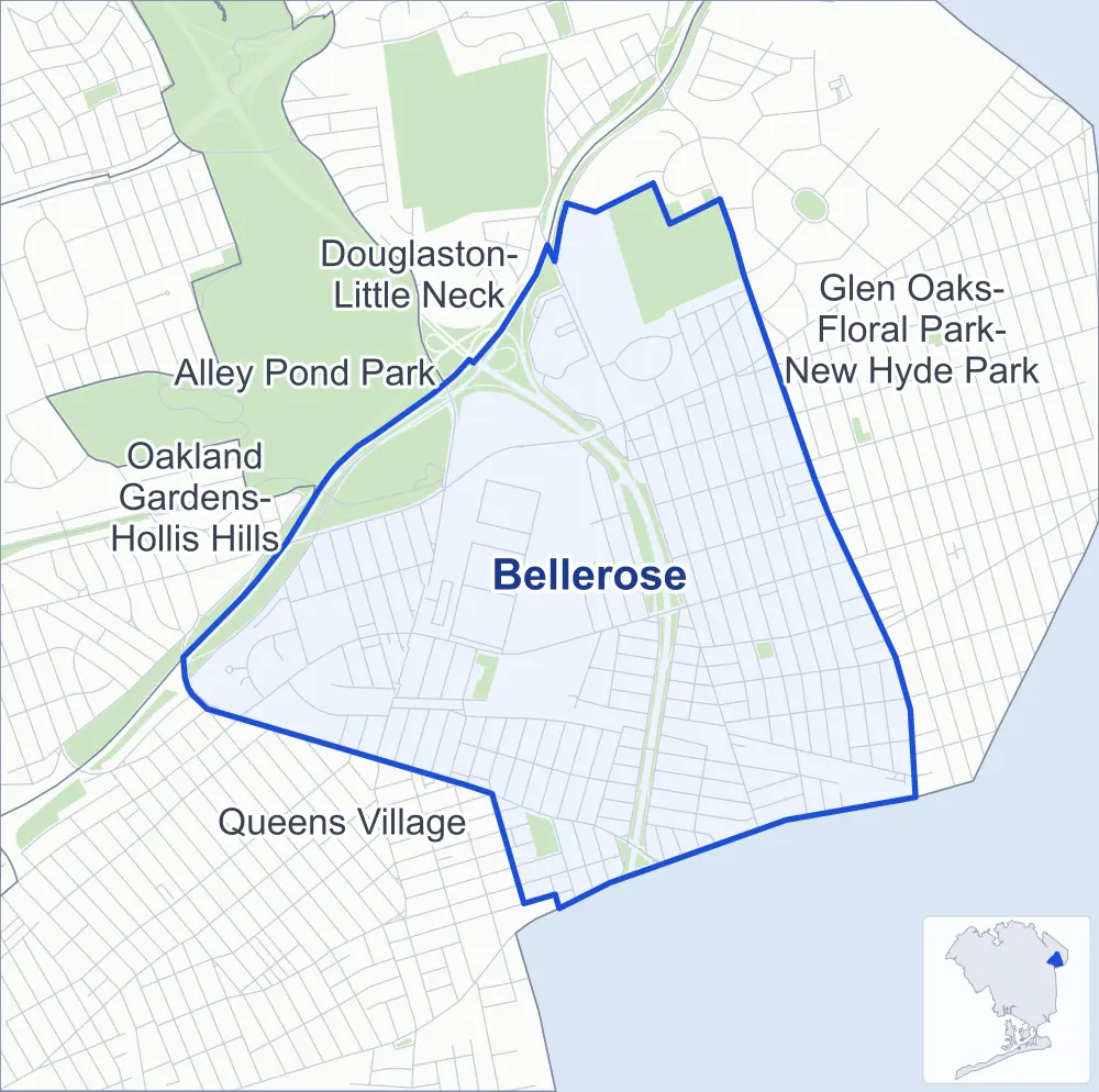
- Bellerose
- A neighboring area
- Park
Neighborhood areas and streets: NYC Department of City Planning. Parks: NYC Parks. Stations: MTA.
Neighboring areas
- Douglaston-Little Neck north
- Glen Oaks-Floral Park-New Hyde Park northeast
- Queens Village southwest
- Oakland Gardens-Hollis Hills west
- Alley Pond Park northwest
Getting around
Buses on 11 routes stop in or at the edge of Bellerose.
- 8 local bus routes
- 3 express bus routes
Local bus routes
- Q1
- Q27
- Q36
- Q43
- Q46
- Q48
- Q88
- Q110
Express bus routes
- QM6
- QM36
- QM68
Safety record
Between 2021 and 2025, its corners averaged fewer police-reported crashes than the average Queens corner.
- 855 police-reported crashes at its corners
- 3.0 a corner, on average
- 5.2 the average Queens corner
- 100 corners with a clean record
Signal or safety changes on City record, at 22 of its corners
- Leading pedestrian intervals
- 17
- Accessible pedestrian signals
- 8
- Safety Improvement Projects
- 2
- Turn calming
- 1
- Barnes Dance all-way crossings
- 1
Camera tickets
In 2025 its corners had more school-zone speed camera tickets than red-light or bus-lane tickets.
- 0 red-light camera tickets
- 59,425 school-zone speed camera tickets at 15 corners
- 0 bus-lane camera tickets
- Most speed tickets
- Hillside Avenue & Avenue C, 17,156
People and homes
The 2020 Census counted 26,566 residents in Bellerose, about 13,400 per square mile.
- 8,933 homes, 2020 Census
- 71 homes added since April 2010, net, by City Planning's count
Half of its 5,497 residential lots hold buildings from 1945 or earlier, and 38% of them date from before 1940, by the City's tax lot records.
Parks and landmarks
- Parkland
- 40.6 acres of NYC Parks property
- The largest pieces
- Alley Athletic Playground (27.5 acres), Alley Pond Park (5.5 acres) and Jack Breininger Park (3.7 acres)
- Designated landmark
- The Creedmoor (Cornell) Farmhouse
Streets and trees
- Trees
- 7,129 in NYC Parks' records, most often London planetree, pin oak and Norway maple
- Street with the most corners
- Hillside Avenue, with 33 of the area's 284
- Height above sea level
- From 83 feet at 93rd Avenue & 243rd Street to 167 feet at Stronghurst Avenue & Grand Central Parkway
- Honorary street names
- 4 at its corners, enacted by local law
Schools and libraries
The City lists ten schools and one library in Bellerose.
- Public schools
- 9
- Charter or private school
- 1
- Library
- Bellerose Library
Public art
The City's public art inventory lists one work in Bellerose: Stein-Goldie Veterans Square (1943).
- 1 work of public art
Public safety
How complaints are countedIn 2025 the NYPD recorded 231 major felonies at places in Bellerose.
Recorded by the NYPD at places in Bellerose
- 227 major felonies in 2024
- 637 other felonies, misdemeanors and violations in 2025
In 2025, on the streets along the edge of Bellerose, the NYPD recorded another nine major felonies. Counting the streets along its edge, in 2025 the NYPD recorded 9.0 major felonies for every thousand residents the 2020 Census counted in Bellerose.
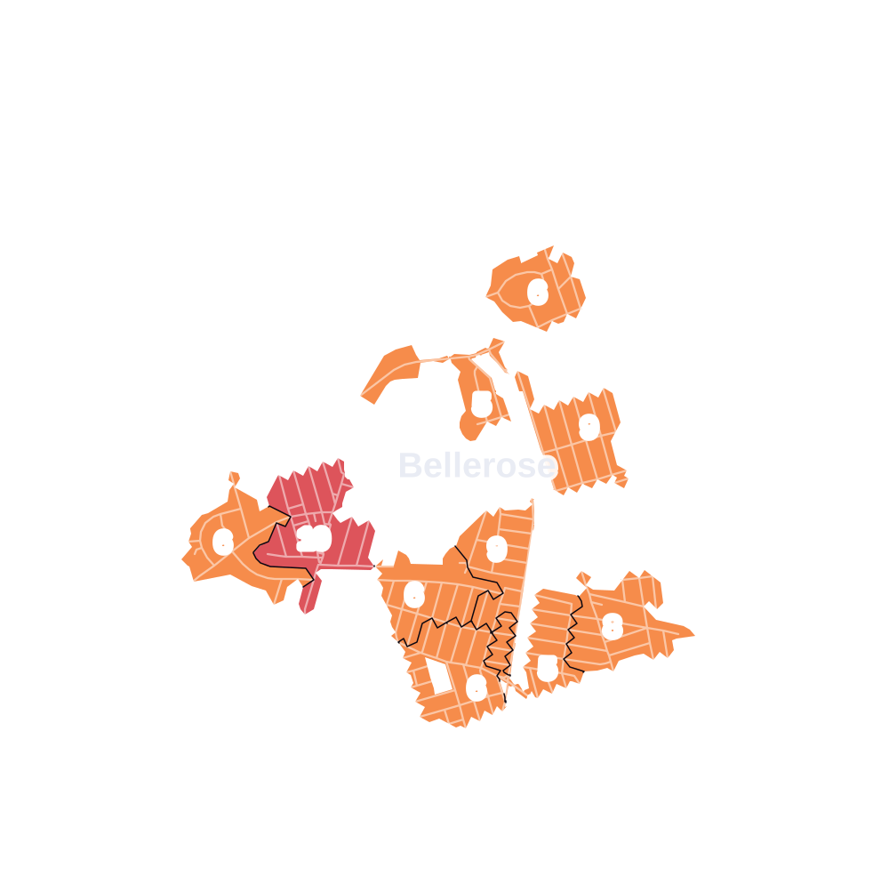
- 5 to 9
- 10 to 19
- 20 to 49
- 50 to 99
- 100 or more
- Not shaded: fewer than 5, held back under the rules in How complaints are counted, parks and public-housing grounds, and land in no patch
- Police precincts
- 105th (most of the area), 111th
From January to June 2026 the NYPD recorded 94 major felonies at places in Bellerose, against 119 in the same months of 2025.
Sources: the NYPD's Complaint Data Historic, updated April 28, 2026, and Complaint Data Current (Year To Date), updated July 27, 2026, on NYC Open Data. Figures to June 30, 2026.
Street corners
- 1st Street & Avenue A
- 1st Street & Avenue C
- 5th Street & Avenue C
- 75th Avenue & Little Neck Parkway
- 76th Avenue & 77th Crescent (north-east)
- 76th Avenue & 77th Crescent (south-west)
- 76th Avenue & Commonwealth Boulevard
- 81st Avenue & 246th Street
- 81st Avenue & 250th Street
- 81st Avenue & 251st Street
- 81st Avenue & 252nd Street
- 82nd Avenue & 242nd Street
- 82nd Avenue & 243rd Street
- 82nd Avenue & 246th Street
- 82nd Avenue & 247th Street
- 82nd Avenue & 248th Street
- 82nd Avenue & 249th Street
- 82nd Avenue & 250th Street
- 82nd Avenue & 251st Street
- 82nd Avenue & 252nd Street
- 82nd Avenue & Commonwealth Boulevard
- 83rd Avenue & 241st Street
- 83rd Avenue & 242nd Street
- 83rd Avenue & 243rd Street
- 83rd Avenue & 246th Street
- 83rd Avenue & 247th Street
- 83rd Avenue & 248th Street
- 83rd Avenue & 250th Street
- 83rd Avenue & 251st Street
- 83rd Avenue & 252nd Street
- 83rd Avenue & 253rd Street
- 83rd Avenue & Commonwealth Boulevard
- 85th Avenue & 241st Street
- 85th Avenue & 246th Street
- 85th Avenue & 247th Street
- 85th Avenue & 248th Street
- 85th Avenue & 249th Street
- 85th Avenue & 250th Street
- 85th Avenue & 251st Street
- 85th Avenue & 252nd Street
- 85th Avenue & 253rd Street
- 85th Avenue & Commonwealth Boulevard
- 85th Road & 246th Street
- 86th Avenue & 239th Street
- 86th Avenue & 241st Street
- 86th Avenue & 246th Street
- 86th Avenue & 247th Street
- 86th Avenue & 248th Street
- 86th Avenue & 249th Street
- 86th Avenue & 250th Street
- 86th Avenue & 251st Street
- 86th Avenue & 252nd Street
- 86th Avenue & 253rd Street
- 86th Avenue & 254th Street
- 86th Avenue & Commonwealth Boulevard
- 86th Road & 246th Street
- 87th Avenue & 233rd Street
- 87th Avenue & 235th Court
- 87th Avenue & 239th Street
- 87th Avenue & 241st Street
- 87th Avenue & 246th Street
- 87th Avenue & 247th Street
- 87th Avenue & 248th Street
- 87th Avenue & 249th Street
- 87th Avenue & 250th Street
- 87th Avenue & 251st Street
- 87th Avenue & 252nd Street
- 87th Avenue & 253rd Street
- 87th Avenue & 254th Street
- 87th Avenue & Commonwealth Boulevard
- 87th Avenue & Musket Street
- 87th Avenue & Range Street
- 87th Avenue & Winchester Boulevard
- 87th Road & 252nd Street
- 88th Avenue & 235th Court
- 88th Avenue & 235th Court at Moline Street
- 88th Avenue & 237th Street
- 88th Avenue & 238th Street
- 88th Avenue & 239th Street
- 88th Avenue & 240th Street
- 88th Avenue & 241st Street
- 88th Avenue & 242nd Street
- 88th Avenue & Ashford Street
- 88th Avenue & Billings Street
- 88th Avenue & Gettysburg Street
- 88th Avenue & Lyman Street
- 88th Avenue & Pontiac Street
- 88th Avenue & Ransom Street
- 88th Avenue & Sabre Street
- 88th Avenue & Winchester Boulevard
- 89th Avenue & 237th Street
- 89th Avenue & 238th Street
- 89th Avenue & 239th Street
- 89th Avenue & 240th Street
- 89th Avenue & 241st Street
- 89th Avenue & 242nd Street
- 89th Avenue & 247th Street
- 89th Avenue & 249th Street
- 89th Avenue & Braddock Avenue
- 89th Avenue & Commonwealth Boulevard
- 89th Avenue & Gettysburg Street
- 89th Avenue & Lyman Street
- 89th Avenue & Moline Street
- 90th Avenue & 242nd Street
- 90th Avenue & 247th Street
- 90th Avenue & Commonwealth Boulevard
- 91st Avenue & 242nd Street
- 91st Avenue & 245th Street
- 91st Avenue & 246th Street
- 91st Avenue & 247th Street
- 91st Avenue & Jericho Turnpike
- 92nd Road & Gettysburg Street
- 93rd Avenue & 239th Street
- 93rd Avenue & 240th Street
- 93rd Avenue & 241st Street
- 93rd Avenue & 242nd Street
- 93rd Avenue & 243rd Street
- 93rd Avenue & Gettysburg Street
- 93rd Road & 239th Street
- 93rd Road & Gettysburg Street
- 229th Street & Manor Road
- 229th Street & Seward Avenue
- 229th Street & Stronghurst Avenue
- 230th Street & Seward Avenue
- 230th Street & Stronghurst Avenue
- 231st Street & 87th Avenue
- 231st Street & Seward Avenue
- 231st Street & Stronghurst Avenue
- 232nd Street & 87th Avenue
- 232nd Street & Seward Avenue
- 233rd Street & Seward Avenue
- 234th Street & Seward Avenue
- 235th Street & Seward Avenue
- 236th Street & Seward Avenue
- 240th Street & 93rd Road
- 240th Street & Fairbury Avenue
- 241st Street & 85th Road
- 241st Street & 86th Road
- 242nd Street & 88th Drive
- 242nd Street & 88th Road
- 242nd Street & Braddock Avenue
- 243rd Street & 242nd Street
- 243rd Street & Cross Island Parkway
- 244th Street & 80th Road
- 245th Street & Jericho Turnpike
- 246th Street & 80th Road
- 247th Street & 77th Crescent
- 247th Street & 81st Avenue
- 247th Street & 85th Road
- 247th Street & 86th Road
- 247th Street & 88th Drive
- 247th Street & 88th Road
- 248th Street & 81st Avenue
- 248th Street & 87th Drive
- 249th Street & 76th Avenue
- 249th Street & 81st Avenue
- 249th Street & 83rd Avenue
- 249th Street & 87th Drive
- 249th Street & 88th Road
- 249th Street & Elkmont Avenue
- 249th Street & Jericho Turnpike
- 249th Street & Shiloh Avenue
- 250th Street & 87th Drive
- 250th Street & 88th Road
- 250th Street & Elkmont Avenue
- 250th Street & Shiloh Avenue
- 251st Street & 87th Drive
- 251st Street & Elkmont Avenue
- 251st Street & Jericho Turnpike
- 251st Street & Shiloh Avenue
- 252nd Street & 80th Avenue
- 252nd Street & 82nd Drive
- 252nd Street & 82nd Road
- 252nd Street & 87th Drive
- 252nd Street & Elkmont Avenue
- 252nd Street & Shiloh Avenue
- 253rd Street & 84th Drive
- 253rd Street & 85th Road
- 253rd Street & 87th Drive
- 253rd Street & 87th Road
- 254th Street & 87th Drive
- 254th Street & 87th Road
- Alley Pond Park Service Road & Cross Island Parkway
- Avenue A & 3rd Street
- Avenue C & 3rd Street
- Avenue C & 4th Street
- Braddock Avenue & 239th Street
- Braddock Avenue & Jericho Turnpike
- Braddock Avenue & Moline Street
- Commonwealth Boulevard & 80th Road
- Commonwealth Boulevard & 81st Avenue
- Commonwealth Boulevard & 84th Road
- Commonwealth Boulevard & 85th Road
- Commonwealth Boulevard & 86th Road
- Commonwealth Boulevard & 87th Drive
- Commonwealth Boulevard & 88th Drive
- Commonwealth Boulevard & 88th Road
- Commonwealth Boulevard & Glen Oaks School Campus Driveway
- Commonwealth Boulevard & Jericho Turnpike
- Cross Island Parkway & 81st Avenue
- Cross Island Parkway & 84th Road
- Cross Island Parkway & 85th Avenue
- Cross Island Parkway & 85th Avenue (Exit 28A)
- Cross Island Parkway & 85th Road
- Cross Island Parkway & 86th Avenue
- Cross Island Parkway & 86th Road
- Cross Island Parkway & 87th Avenue
- Cross Island Parkway & 88th Avenue
- Cross Island Parkway & 88th Drive
- Cross Island Parkway & 88th Road
- Cross Island Parkway & 89th Avenue
- Cross Island Parkway & 90th Avenue
- Cross Island Parkway & 90th Avenue (Exit 27W)
- Cross Island Parkway & 91st Avenue
- Cross Island Parkway & 243rd Street
- Cross Island Parkway & 244th Street
- Cross Island Parkway & Braddock Avenue
- Cross Island Parkway & Hillside Avenue
- Cross Island Parkway & Hillside Avenue (Exit 28A)
- Cross Island Parkway & Hillside Avenue (Hillside Avenue)
- Cross Island Parkway & Jamaica Avenue
- Cross Island Parkway & Union Turnpike
- Gettysburg Street & Fairbury Avenue
- Glen Oaks School Campus & Glen Oaks School Campus Driveway
- Grand Central Parkway & Douglaston Parkway at Winchester Boulevard
- Grand Central Parkway & Union Turnpike at Stronghurst Avenue
- Grand Central Parkway & Winchester Boulevard
- Hillside Avenue & 84th Road
- Hillside Avenue & 88th Avenue
- Hillside Avenue & 229th Street
- Hillside Avenue & 231st Street
- Hillside Avenue & 232nd Street
- Hillside Avenue & 233rd Street
- Hillside Avenue & 234th Street
- Hillside Avenue & 235th Court
- Hillside Avenue & 239th Street
- Hillside Avenue & 240th Street
- Hillside Avenue & 241st Street
- Hillside Avenue & 242nd Street
- Hillside Avenue & 243rd Street
- Hillside Avenue & 246th Street
- Hillside Avenue & 247th Street
- Hillside Avenue & 248th Street
- Hillside Avenue & 249th Street
- Hillside Avenue & 250th Street
- Hillside Avenue & 251st Street
- Hillside Avenue & 252nd Street
- Hillside Avenue & 253rd Street
- Hillside Avenue & Avenue A
- Hillside Avenue & Avenue C
- Hillside Avenue & Commonwealth Boulevard
- Hillside Avenue & Cross Island Parkway
- Hillside Avenue & Little Neck Parkway
- Hillside Avenue & Manor Road
- Hillside Avenue & Musket Street
- Hillside Avenue & Range Street
- Hillside Avenue & Winchester Boulevard
- Jamaica Avenue & 239th Street
- Jamaica Avenue & 241st Street
- Jamaica Avenue & 242nd Street
- Little Neck Parkway & 73rd Road
- Little Neck Parkway & 82nd Drive
- Little Neck Parkway & 86th Avenue
- Little Neck Parkway & 87th Avenue
- Little Neck Parkway & East Williston Avenue
- Little Neck Parkway & Elkmont Avenue
- Little Neck Parkway & Shiloh Avenue
- Springfield Boulevard & Braddock Avenue at Spencer Avenue
- Springfield Boulevard & Stronghurst Avenue
- Stronghurst Avenue & Grand Central Parkway
- Union Turnpike & 234th Street
- Union Turnpike & 243rd Street
- Union Turnpike & 247th Street
- Union Turnpike & 249th Street
- Union Turnpike & Commonwealth Boulevard
- Union Turnpike & Glen Oaks School Campus (east)
- Union Turnpike & Glen Oaks School Campus (west)
- Union Turnpike & Little Neck Parkway
- Union Turnpike & Winchester Boulevard
- Winchester Boulevard & 237th Street
- Winchester Boulevard & Braddock Avenue
- Winchester Boulevard & Cross Island Parkway
- Winchester Boulevard & Grand Central Parkway
- Winchester Boulevard & Seward Avenue
How the figures above are measured: Methodology.