Kingsbridge Heights-Van Cortlandt Village
Neighborhood · Bronx
Kingsbridge Heights-Van Cortlandt Village lies in the northwest Bronx along the western and northern sides of the Jerome Park Reservoir, from Kingsbridge Road up to Van Cortlandt Park, with the Major Deegan Expressway to the west.
- 0.39 square miles
- 35,777 residents, 2020 Census
- 85 street corners
- 8 bus routes
Its name comes from the King's Bridge, built across Spuyten Duyvil Creek in the late 1600s by manor lord Frederick Philipse, and Patriot troops fortified the Kingsbridge area in 1776 before British forces seized it. Van Cortlandt Village, the northern section, is home to the Amalgamated Housing Cooperative, founded in 1927 and the oldest limited-equity housing cooperative in the United States.
Sources: Kingsbridge Heights, Bronx (Wikipedia); Kingsbridge Heights (Bronx Community Board 7); Kingsbridge, Bronx (Wikipedia); Amalgamated Housing Cooperative.
Kingsbridge Heights-Van Cortlandt Village borders five areas, and Bailey Avenue holds more of its corners than any other street, 15 of 85.
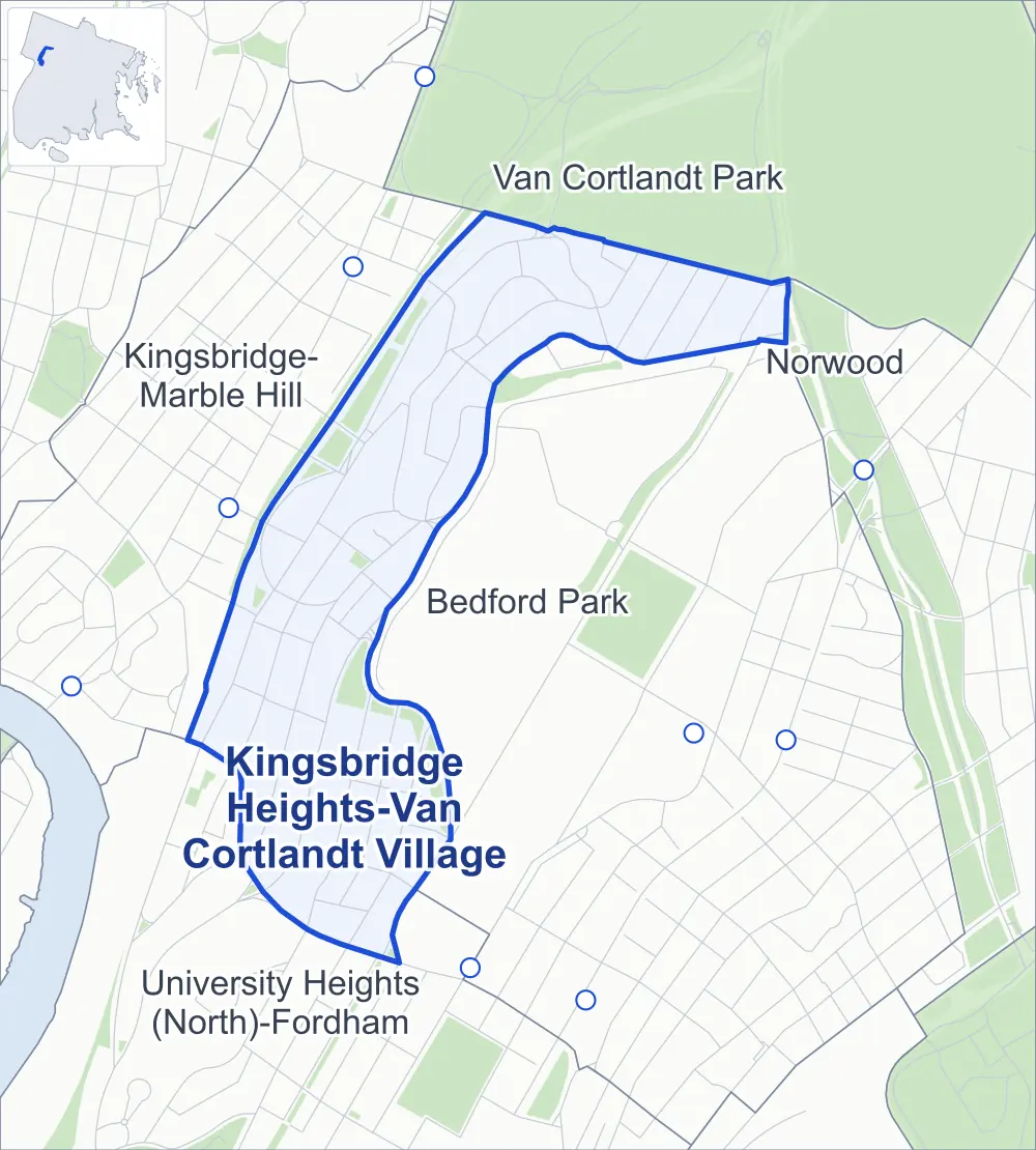
- Kingsbridge Heights-Van Cortlandt Village
- A neighboring area
- Park
- Another station
Neighborhood areas and streets: NYC Department of City Planning. Parks: NYC Parks. Stations: MTA.
Neighboring areas
- Van Cortlandt Park northeast
- Norwood northeast
- Bedford Park east
- University Heights (North)-Fordham south
- Kingsbridge-Marble Hill northwest
Getting around
Buses on eight routes stop in or at the edge of Kingsbridge Heights-Van Cortlandt Village.
- 7 local bus routes
- 1 express bus route
Local bus routes
- Bx1
- Bx2
- Bx3
- Bx9
- Bx10
- Bx22
- Bx32
Express bus route
- BxM3
Safety record
Between 2021 and 2025, its corners averaged more police-reported crashes than the average Bronx corner.
- 694 police-reported crashes at its corners
- 8.2 a corner, on average
- 8.0 the average Bronx corner
- 8 corners with a clean record
Signal or safety changes on City record, at 24 of its corners
- Accessible pedestrian signals
- 16
- Leading pedestrian intervals
- 11
- Turn calming
- 5
- Enhanced crossings
- 5
- Barnes Dance all-way crossings
- 4
- Safety Improvement Projects
- 3
Camera tickets
In 2025 its corners had more school-zone speed camera tickets than red-light or bus-lane tickets.
- 0 red-light camera tickets
- 5,555 school-zone speed camera tickets at six corners
- 0 bus-lane camera tickets
- Most speed tickets
- University Avenue & Reservoir Avenue, 3,971
People and homes
The 2020 Census counted 35,777 residents in Kingsbridge Heights-Van Cortlandt Village, about 91,700 per square mile.
- 13,638 homes, 2020 Census
- 998 homes added since April 2010, net, by City Planning's count
Half of its 912 residential lots hold buildings from 1928 or earlier, and 72% of them date from before 1940, by the City's tax lot records.
Parks and landmarks
- Parkland
- 9.7 acres of NYC Parks property
- The largest pieces
- Washington's Walk (4.8 acres), Bailey Playground (3.2 acres) and Cooney Grauer Field (1.3 acres)
- Designated landmark
- 40th Police Precinct Station House
Streets and trees
- Trees
- 1,721 in NYC Parks' records, most often pin oak, thornless honeylocust and American basswood
- Street with the most corners
- Bailey Avenue, with 15 of the area's 85
- Height above sea level
- From 18 feet at Bailey Avenue & West 229th Street to 169 feet at Claflin Avenue & West 197th Street
- Honorary street names
- 7 at its corners, enacted by local law
Schools and libraries
The City lists nine schools and two libraries in Kingsbridge Heights-Van Cortlandt Village.
- Public schools
- 7
- Charter and private schools
- 2
- Libraries
- Jerome Park Library; and Van Cortlandt Library, Arline Schwarzman Building
Bike share
By the station list of October 3, 2026, 11 bike-share stations stand in Kingsbridge Heights-Van Cortlandt Village.
- 11 bike-share stations
Public safety
How complaints are countedIn 2025 the NYPD recorded 338 major felonies at places in Kingsbridge Heights-Van Cortlandt Village.
Recorded by the NYPD at places in Kingsbridge Heights-Van Cortlandt Village
- 379 major felonies in 2024
- 1,113 other felonies, misdemeanors and violations in 2025
In 2025, on the streets along the edge of Kingsbridge Heights-Van Cortlandt Village, the NYPD recorded another 122 major felonies. Counting the streets along its edge, in 2025 the NYPD recorded 12.9 major felonies for every thousand residents the 2020 Census counted in Kingsbridge Heights-Van Cortlandt Village.
- Police precinct
- 50th
From January to June 2026 the NYPD recorded 177 major felonies at places in Kingsbridge Heights-Van Cortlandt Village, against 190 in the same months of 2025.
Sources: the NYPD's Complaint Data Historic, updated April 28, 2026, and Complaint Data Current (Year To Date), updated July 27, 2026, on NYC Open Data. Figures to June 30, 2026.
Street corners
- Albany Crescent & West 233rd Street
- Bailey Avenue & Albany Crescent
- Bailey Avenue & Bailey Place
- Bailey Avenue & Charles Halley Place
- Bailey Avenue & Summit Place
- Bailey Avenue & Van Cortlandt Avenue West
- Bailey Avenue & Van Cortlandt Park South
- Bailey Avenue & Van Cortlandt Park South at Van Cortlandt Avenue West
- Bailey Avenue & West 229th Street
- Bailey Avenue & West 230th Street
- Bailey Avenue & West 231st Street
- Bailey Avenue & West 233rd Street
- Bailey Avenue & West 234th Street
- Bailey Avenue & West 234th Street at Bailey Place
- Bailey Avenue & West 238th Street
- Bailey Avenue & West Kingsbridge Road
- Cannon Place & Giles Place
- Claflin Avenue & Eames Place
- Claflin Avenue & West 197th Street
- Fort Independence Street & Bailey Place
- Goulden Avenue & Reservoir Avenue
- Heath Avenue & Albany Crescent
- Heath Avenue & Fort Independence Street
- Heath Avenue & Summit Place
- Heath Avenue & West 229th Street
- Heath Avenue & West Kingsbridge Road
- Kingsbridge Terrace & Albany Crescent
- Kingsbridge Terrace & Fort Independence Street
- Kingsbridge Terrace & Perot Street
- Kingsbridge Terrace & Shrady Place
- Kingsbridge Terrace & Summit Place
- Kingsbridge Terrace & West 229th Street
- Major Deegan Expressway & Van Cortlandt Park South
- Major Deegan Expressway & West 231st Street
- Major Deegan Expressway & West 233rd Street
- Major Deegan Expressway & West 234th Street
- Major Deegan Expressway & West 238th Street
- Orloff Avenue & Cannon Place (north-east)
- Orloff Avenue & Cannon Place (south-west)
- Orloff Avenue & Charles Halley Place
- Orloff Avenue & Gale Place
- Perot Street & Armand Place
- Reservoir Avenue & Webb Avenue
- Reservoir Avenue & West 197th Street
- Reservoir Avenue & West Kingsbridge Road
- Sedgwick Avenue & Dickinson Avenue
- Sedgwick Avenue & Fort Independence Street at Giles Place
- Sedgwick Avenue & Goulden Avenue
- Sedgwick Avenue & Perot Street
- Sedgwick Avenue & Reservoir Avenue
- Sedgwick Avenue & Stevenson Place
- Sedgwick Avenue & Van Cortlandt Avenue West
- Sedgwick Avenue & West 195th Street
- Sedgwick Avenue & West 197th Street
- Sedgwick Avenue & West 229th Street
- Sedgwick Avenue & West 238th Street
- University Avenue & Eames Place
- University Avenue & Reservoir Avenue
- University Avenue & Strong Street
- University Avenue & West 195th Street
- University Avenue & West 197th Street
- Van Cortlandt Avenue West & Orloff Avenue
- Van Cortlandt Park South & Gale Place
- Van Cortlandt Park South & Gouverneur Avenue
- Van Cortlandt Park South & Hillman Avenue
- Van Cortlandt Park South & Major Deegan Expressway
- Van Cortlandt Park South & Mosholu Parkway
- Van Cortlandt Park South & Orloff Avenue
- Van Cortlandt Park South & Saxon Avenue
- Webb Avenue & Eames Place
- Webb Avenue & West 195th Street
- Webb Avenue & West 197th Street
- Webb Avenue & West Kingsbridge Road
- West 195th Street & Claflin Avenue
- West 230th Street & Heath Avenue
- West 230th Street & Kingsbridge Terrace
- West 230th Street & Major Deegan Expressway (north-west)
- West 230th Street & Major Deegan Expressway (south-east)
- West 231st Street & Albany Crescent
- West 231st Street & Berkwit Terrace
- West 231st Street & Kingsbridge Terrace
- West 238th Street & Cannon Place
- West 238th Street & Orloff Avenue
- West 238th Street & Orloff Avenue at Fort Independence Street
- West Kingsbridge Road & Kingsbridge Terrace
How the figures above are measured: Methodology.