Van Cortlandt Park
Park · Bronx
Spreading over 1,146 acres at the north end of the Bronx, beside Woodlawn Heights, Van Cortlandt Park is New York City's third-largest park, owned by the city's parks department and cared for with the help of the Van Cortlandt Park Alliance.
- 1.82 square miles
- 13 street corners
- 2 subway stations
- 8 bus routes
It became parkland in 1888 on land the Van Cortlandt family sold to the city, and the family's house of 1748, the oldest known surviving house in the Bronx, has been a museum since 1897. The park is known for the nation's first municipal golf course, opened in 1895, its cross-country running course and Van Cortlandt Lake, made in the 1690s by damming Tibbetts Brook to power a gristmill.
Sources: Visit the Park (Van Cortlandt Park Alliance); Van Cortlandt Park (Wikipedia); Van Cortlandt Mansion, Interior (LP-0890), July 22, 1975 (NYC Landmarks Preservation Commission); Woodlawn Heights, Bronx (Wikipedia).
Van Cortlandt Park borders six areas, and Major Deegan Expressway holds more of its corners than any other street, 11 of 13.
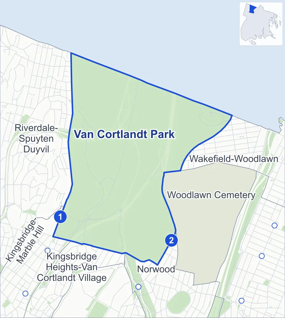
- Van Cortlandt Park
- A neighboring area
- Park
- A station in the list
- Another station
Neighborhood areas and streets: NYC Department of City Planning. Parks: NYC Parks. Stations: MTA.
Neighboring areas
- Wakefield-Woodlawn east
- Woodlawn Cemetery southeast
- Norwood south
- Kingsbridge Heights-Van Cortlandt Village south
- Kingsbridge-Marble Hill southwest
- Riverdale-Spuyten Duyvil northwest
Subway stations
- Van Cortlandt Park-242 St lines 1
- Woodlawn lines 4
Getting around
Two subway stations and buses on eight routes stop in or at the edge of Van Cortlandt Park.
- 2 subway stations
- 6 local bus routes
- 2 express bus routes
Local bus routes
- Bx9
- Bx10
- Bx16
- Bx31
- Bx34
- BX95
Express bus routes
- BxM3
- BxM4
Safety record
Between 2021 and 2025, its corners averaged more police-reported crashes than the average Bronx corner.
- 156 police-reported crashes at its corners
- 12.0 a corner, on average
- 8.0 the average Bronx corner
- 5 corners with a clean record
Camera tickets
In 2025 the Department of Finance recorded no red-light, school-zone speed or bus-lane camera ticket at its corners.
Parks
- Parkland
- 1075.7 acres of Van Cortlandt Park, as NYC Parks maps it within the area's boundary
Streets and trees
- Trees
- 3,986 in NYC Parks' records, most often pin oak, pumpkin ash and northern red oak
- Street with the most corners
- Major Deegan Expressway, with 11 of the area's 13
- Height above sea level
- From 24 feet at Van Cortlandt Avenue West & Major Deegan Expressway to 212 feet at Jerome Avenue & Major Deegan Expressway
Bike share and public art
By the station list of October 3, 2026, five bike-share stations stand in Van Cortlandt Park. The City's public art inventory lists five works in the area, among them General Josiah Porter (1902), Algernon Sidney Sullivan (1906) and Van Cortlandt Memorial Grove (39 tablets) (1949).
- 5 bike-share stations
- 5 works of public art
Street corners
- Henry Hudson Parkway & Mosholu Parkway
- Jerome Avenue & East 233rd Street at Major Deegan Expressway
- Jerome Avenue & East 233rd Street at Major Deegan Expressway (Exit 13)
- Jerome Avenue & Major Deegan Expressway (East 233rd Street)
- Jerome Avenue & Major Deegan Expressway (Exit 13)
- Jerome Avenue & Major Deegan Expressway (Exit 14)
- Jerome Avenue & Major Deegan Expressway (Jerome Avenue)
- Major Deegan Expressway & Mosholu Parkway
- Major Deegan Expressway & Van Cortlandt Avenue West
- Mosholu Avenue & Van Cortlandt Park Bridle Trail
- Mosholu Parkway & Major Deegan Expressway
- Van Cortlandt Avenue West & Major Deegan Expressway
- Van Cortlandt Avenue West & Major Deegan Expressway (Exit 11)
How the figures above are measured: Methodology.