Norwood
Neighborhood · Bronx
Bordered on the north by Van Cortlandt Park and Woodlawn Cemetery, Norwood lies in the northwest Bronx between Mosholu Parkway and the Bronx River.
- 0.56 square miles
- 43,466 residents, 2020 Census
- 107 street corners
- 3 subway stations
- 14 bus routes
It began as a dairy farm owned by the Varian family, whose name lives on in the Valentine-Varian House, an 18th-century fieldstone farmhouse that became a city landmark in 1966 and now holds the Museum of Bronx History. The name may be a shortening of North Woods, and the area is also known as Bainbridge, after the shopping strip at Bainbridge Avenue and East 204th Street. A late-19th-century reservoir here was later turned into Williamsbridge Oval, a park with playgrounds, courts and a football field.
Sources: Norwood, Bronx (Wikipedia); Norwood (Bronx Community Board 7); Varian House (LP-0119), Designation Number 1, March 15, 1966 (NYC Landmarks Preservation Commission).
Norwood borders seven areas, and Bainbridge Avenue holds more of its corners than any other street, 15 of 107.
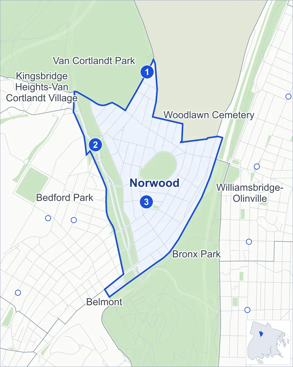
- Norwood
- A neighboring area
- Park
- A station in the list
- Another station
Neighborhood areas and streets: NYC Department of City Planning. Parks: NYC Parks. Stations: MTA.
Neighboring areas
- Van Cortlandt Park north
- Woodlawn Cemetery northeast
- Williamsbridge-Olinville east
- Bronx Park southeast
- Belmont south
- Bedford Park southwest
- Kingsbridge Heights-Van Cortlandt Village northwest
Subway stations
- Woodlawn lines 4
- Mosholu Pkwy lines 4 accessible
- Norwood-205 St lines D
Getting around
Three subway stations and buses on 14 routes stop in or at the edge of Norwood.
- 3 subway stations
- 1 of them listed by the MTA as fully accessible
- 13 local bus routes
- 1 express bus route
Local bus routes
- Bx1
- Bx2
- Bx10
- Bx16
- Bx25
- Bx26
- Bx28
- Bx34
- Bx38
- Bx41
- Bx41-SBS
- BX95
- T127
Express bus route
- BxM4
Safety record
Between 2021 and 2025, its corners averaged more police-reported crashes than the average Bronx corner.
- 1,435 police-reported crashes at its corners
- 13.4 a corner, on average
- 8.0 the average Bronx corner
- 6 corners with a clean record
Signal or safety changes on City record, at 32 of its corners
- Accessible pedestrian signals
- 20
- Leading pedestrian intervals
- 18
- Turn calming
- 5
- Barnes Dance all-way crossings
- 3
- Enhanced crossings
- 2
Camera tickets
In 2025 its corners had more bus-lane camera tickets than school-zone speed or red-light tickets.
- 0 red-light camera tickets
- 5,701 school-zone speed camera tickets at four corners
- 8,771 bus-lane camera tickets at four corners
- Most speed tickets
- Bainbridge Avenue & East 213th Street, 3,743
- Most bus-lane tickets
- East Gun Hill Road & Decatur Avenue, 4,026
People and homes
The 2020 Census counted 43,466 residents in Norwood, about 77,600 per square mile.
- 15,908 homes, 2020 Census
- 1,264 homes added since April 2010, net, by City Planning's count
Half of its 853 residential lots hold buildings from 1923 or earlier, and 87% of them date from before 1940, by the City's tax lot records.
Parks and landmarks
- Parkland
- 18.9 acres of Williamsbridge Oval, as NYC Parks maps it within Norwood
- Designated landmarks
- The Williamsbridge Reservoir Keeper's House, the Isaac Valentine House, 52nd Police Precinct Station House and 52nd Police Precinct Station House - Stable
Streets and trees
- Trees
- 4,647 in NYC Parks' records, most often pin oak, thornless honeylocust and red maple
- Street with the most corners
- Bainbridge Avenue, with 15 of the area's 107
- Height above sea level
- From 64 feet at Webster Avenue & East 201st Street to 193 feet at Bainbridge Avenue & East 210th Street
- Honorary street names
- 2 at its corners, enacted by local law
Schools and libraries
The City lists 12 schools and one library in Norwood.
- Public schools
- 8
- Charter and private schools
- 4
- Library
- Mosholu Library
Bike share and public art
By the station list of October 3, 2026, 19 bike-share stations stand in Norwood. The City's public art inventory lists two works in the area: Bronx Victory Memorial (1925) and Bronx River Soldier (1970).
- 19 bike-share stations
- 2 works of public art
Public safety
How complaints are countedIn 2025 the NYPD recorded 700 major felonies at places in Norwood.
Recorded by the NYPD at places in Norwood
- 633 major felonies in 2024
- 1,617 other felonies, misdemeanors and violations in 2025
In 2025, on the streets along the edge of Norwood, the NYPD recorded another 126 major felonies. Counting the streets along its edge, in 2025 the NYPD recorded 19.0 major felonies for every thousand residents the 2020 Census counted in Norwood.
- Police precinct
- 52nd
From January to June 2026 the NYPD recorded 336 major felonies at places in Norwood, against 324 in the same months of 2025.
Sources: the NYPD's Complaint Data Historic, updated April 28, 2026, and Complaint Data Current (Year To Date), updated July 27, 2026, on NYC Open Data. Figures to June 30, 2026.
Street corners
- Bainbridge Avenue & East 205th Street
- Bainbridge Avenue & East 206th Street
- Bainbridge Avenue & East 207th Street
- Bainbridge Avenue & East 208th Street
- Bainbridge Avenue & East 210th Street
- Bainbridge Avenue & East 211th Street
- Bainbridge Avenue & East 212th Street
- Bainbridge Avenue & East 213th Street
- Bainbridge Avenue & East Mosholu Parkway North
- Bainbridge Avenue & East Mosholu Parkway South
- Bainbridge Avenue & Rochambeau Avenue
- Bainbridge Avenue & Van Cortlandt Avenue East
- Bronx River Greenway & East 204th Street Footbridge
- Decatur Avenue & East 204th Street
- Decatur Avenue & East 205th Street
- Decatur Avenue & East 207th Street
- Decatur Avenue & East 209th Street
- Decatur Avenue & East Mosholu Parkway North
- Dekalb Avenue & East 208th Street
- Dekalb Avenue & Kossuth Avenue
- East 207th Street & Parkside Place
- East 208th Street & Kossuth Avenue
- East 208th Street & Steuben Avenue
- East 210th Street & Kossuth Avenue
- East 210th Street & Steuben Avenue
- East 210th Street & Wayne Avenue
- East 211th Street & Hull Avenue
- East 211th Street & Kings College Place
- East 211th Street & Perry Avenue
- East 211th Street & Putnam Place
- East 211th Street & Tryon Avenue
- East 211th Street & Wayne Avenue
- East 212th Street & Dekalb Avenue
- East 212th Street & Rochambeau Avenue
- East 213th Street & Dekalb Avenue
- East Gun Hill Road & Bainbridge Avenue
- East Gun Hill Road & Decatur Avenue
- East Gun Hill Road & Dekalb Avenue
- East Gun Hill Road & Hull Avenue
- East Gun Hill Road & Kings College Place
- East Gun Hill Road & Perry Avenue
- East Gun Hill Road & Putnam Place
- East Gun Hill Road & Rochambeau Avenue
- East Gun Hill Road & Tryon Avenue
- East Gun Hill Road & Wayne Avenue
- East Mosholu Parkway North & East 206th Street
- East Mosholu Parkway North & Hull Avenue
- East Mosholu Parkway North & Kossuth Avenue
- East Mosholu Parkway North & Steuben Avenue
- East Mosholu Parkway North & Van Cortlandt Avenue East
- East Mosholu Parkway South & East 205th Street
- East Mosholu Parkway South & East 206th Street
- East Mosholu Parkway South & Van Cortlandt Avenue East
- Goulden Avenue & West Mosholu Parkway South
- Hull Avenue & East 204th Street
- Hull Avenue & East 205th Street
- Hull Avenue & East 207th Street
- Hull Avenue & East 209th Street
- Jerome Avenue & Bainbridge Avenue
- Jerome Avenue & East 208th Street
- Jerome Avenue & East 212th Street
- Jerome Avenue & East 213th Street
- Jerome Avenue & Gun Hill Road
- Jerome Avenue & Mosholu Parkway North
- Mosholu Parkway & Bainbridge Avenue
- Mosholu Parkway & Marion Avenue
- Mosholu Parkway & Paul Avenue
- Mosholu Parkway & Sedgwick Avenue
- Mosholu Parkway & Van Cortlandt Avenue East
- Mosholu Parkway & Van Cortlandt Park South
- Parkside Place & East 209th Street
- Paul Avenue & West Mosholu Parkway South
- Perry Avenue & East 204th Street
- Perry Avenue & East 205th Street
- Perry Avenue & East 206th Street
- Perry Avenue & East 207th Street
- Perry Avenue & East 209th Street
- Perry Avenue & East Mosholu Parkway North
- Perry Avenue & Holt Place
- Reservoir Oval East & Holt Place
- Reservoir Oval East & Reservoir Oval West
- Reservoir Oval East & Reservoir Place
- Reservoir Oval East & Van Cortlandt Avenue East
- Reservoir Oval West & East 208th Street
- Reservoir Oval West & Tryon Avenue
- Reservoir Oval West & Wayne Avenue
- Rochambeau Avenue & East 206th Street
- Rochambeau Avenue & East 208th Street
- Rochambeau Avenue & East 210th Street
- Rochambeau Avenue & Van Cortlandt Avenue East
- Sedgwick Avenue & West Mosholu Parkway South
- Webster Avenue & Bedford Park Boulevard
- Webster Avenue & East 201st Street
- Webster Avenue & East 202nd Street
- Webster Avenue & East 203rd Street
- Webster Avenue & East 204th Street
- Webster Avenue & East 205th Street
- Webster Avenue & East Gun Hill Road
- Webster Avenue & East Mosholu Parkway North
- Webster Avenue & Parkside Place (north-east)
- Webster Avenue & Parkside Place (south-west)
- West Gun Hill Road & Gates Place
- West Gun Hill Road & Knox Place
- West Gun Hill Road & Mosholu Parkway
- West Gun Hill Road & West Mosholu Parkway North
- West Mosholu Parkway North & Gates Place
- West Mosholu Parkway North & Knox Place
How the figures above are measured: Methodology.