Williamsbridge-Olinville
Neighborhood · Bronx
Williamsbridge and Olinville sit in the north-central Bronx, on the east side of the Bronx River.
- 1.30 square miles
- 61,346 residents, 2020 Census
- 217 street corners
- 4 subway stations
- 11 bus routes
Williamsbridge takes its name from John Williams, an 18th-century farmer whose land on the river's east bank lay nearest the earliest bridge there, and by the 1800s both the crossing and the settlement carried his name; Olinville honors Stephen Olin, a Methodist Episcopal minister. Williamsbridge was incorporated as a village in 1888, and today its streets are lined mostly with owner-occupied two- and three-story homes and some apartment buildings, served by the 2 and 5 trains of the White Plains Road line.
Sources: Williamsbridge, Bronx (Wikipedia); Williamsbridge Oval Playground (NYC Parks); About (Bronx Community Board 12).
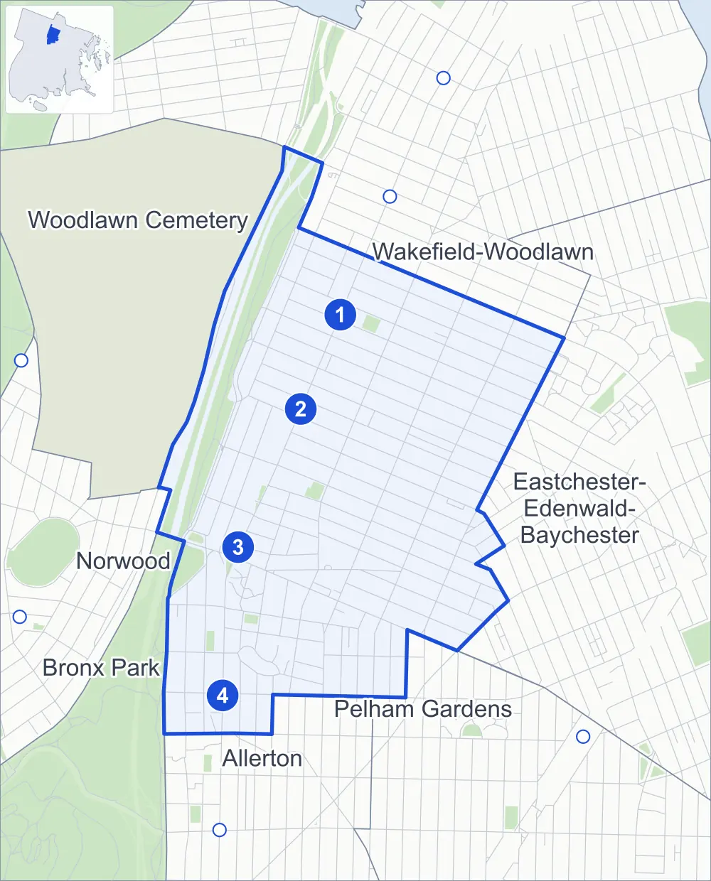
Williamsbridge-Olinville borders seven areas, and White Plains Road holds more of its corners than any other street, 27 of 217.
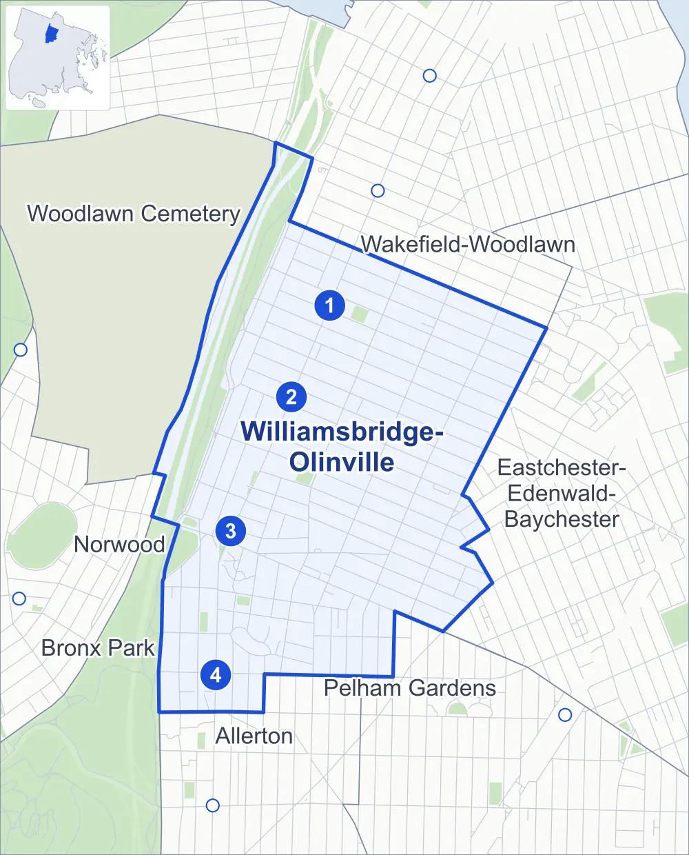
- Williamsbridge-Olinville
- A neighboring area
- Park
- A station in the list
- Another station
Neighborhood areas and streets: NYC Department of City Planning. Parks: NYC Parks. Stations: MTA.
Neighboring areas
- Wakefield-Woodlawn north
- Eastchester-Edenwald-Baychester east
- Pelham Gardens southeast
- Allerton south
- Bronx Park southwest
- Norwood west
- Woodlawn Cemetery northwest
Subway stations
- 225 St lines 2 5
- 219 St lines 2 5
- Gun Hill Rd lines 2 5 accessible
- Burke Av lines 2 5
Getting around
Four subway stations and buses on 11 routes stop in or at the edge of Williamsbridge-Olinville.
- 4 subway stations
- 1 of them listed by the MTA as fully accessible
- 10 local bus routes
- 1 express bus route
Local bus routes
- Bx8
- Bx16
- Bx28
- Bx30
- Bx31
- Bx38
- Bx39
- Bx41
- Bx41-SBS
- T117
Express bus route
- BxM11
Safety record
Between 2021 and 2025, its corners averaged more police-reported crashes than the average Bronx corner.
- 1,997 police-reported crashes at its corners
- 9.2 a corner, on average
- 8.0 the average Bronx corner
- 16 corners with a clean record
Signal or safety changes on City record, at 48 of its corners
- Leading pedestrian intervals
- 37
- Accessible pedestrian signals
- 33
- Enhanced crossings
- 5
- Safety Improvement Projects
- 5
- Turn calming
- 3
- Barnes Dance all-way crossings
- 1
Camera tickets
In 2025 its corners had more school-zone speed camera tickets than red-light or bus-lane tickets.
- 3,830 red-light camera tickets at two corners
- 9,510 school-zone speed camera tickets at 14 corners
- 0 bus-lane camera tickets
- Most red-light tickets
- Paulding Avenue & East 222nd Street, 1,962
- Most speed tickets
- Bronx Boulevard & Rosewood Street, 2,010
People and homes
The 2020 Census counted 61,346 residents in Williamsbridge-Olinville, about 47,200 per square mile.
- 22,867 homes, 2020 Census
- 3,454 homes added since April 2010, net, by City Planning's count
Half of its 5,741 residential lots hold buildings from 1940 or earlier, and 48% of them date from before 1940, by the City's tax lot records.
NYCHA development
NYCHA's Gun Hill development lies wholly or partly within Williamsbridge-Olinville.
Parks
- Parkland
- 5.7 acres of NYC Parks property
- The largest pieces
- Agnes Haywood Playground (1.3 acres), Marcus Garvey Square (1.2 acres) and Rienzi Playground (1.2 acres)
Streets and trees
- Trees
- 4,587 in NYC Parks' records, most often London planetree, pin oak and thornless honeylocust
- Street with the most corners
- White Plains Road, with 27 of the area's 217
- Height above sea level
- From 65 feet at Barker Avenue & Duncomb Avenue to 176 feet at Paulding Avenue & East 221st Street
- Honorary street names
- 13 at its corners, enacted by local law
Schools
The City lists 22 schools in Williamsbridge-Olinville.
- Public schools
- 12
- Charter and private schools
- 10
Public safety
How complaints are countedIn 2025 the NYPD recorded 1,195 major felonies at places in Williamsbridge-Olinville.
Recorded by the NYPD at places in Williamsbridge-Olinville
- 1,034 major felonies in 2024
- 3,707 other felonies, misdemeanors and violations in 2025
In 2025, on the streets along the edge of Williamsbridge-Olinville, the NYPD recorded another 179 major felonies. Counting the streets along its edge, in 2025 the NYPD recorded 22.4 major felonies for every thousand residents the 2020 Census counted in Williamsbridge-Olinville.
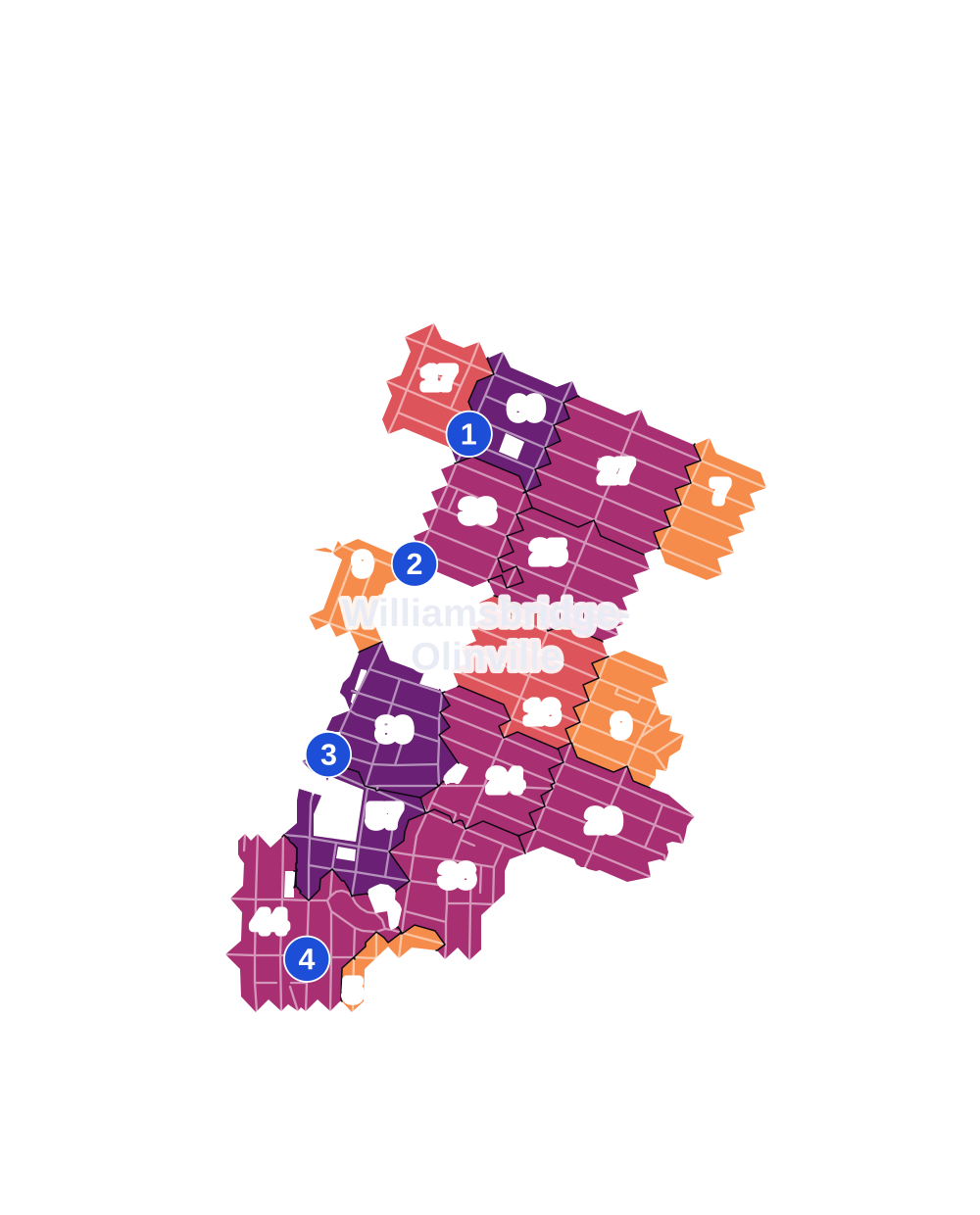
- 5 to 9
- 10 to 19
- 20 to 49
- 50 to 99
- 100 or more
- Not shaded: fewer than 5, held back under the rules in How complaints are counted, parks and public-housing grounds, and land in no patch
- Police precinct
- 47th
From January to June 2026 the NYPD recorded 479 major felonies at places in Williamsbridge-Olinville, against 602 in the same months of 2025.
Sources: the NYPD's Complaint Data Historic, updated April 28, 2026, and Complaint Data Current (Year To Date), updated July 27, 2026, on NYC Open Data. Figures to June 30, 2026.
Street corners
- Adee Avenue & Barker Avenue
- Adee Avenue & Bronx Park East
- Adee Avenue & Cruger Avenue
- Barker Avenue & Duncomb Avenue
- Barker Avenue & Lester Street
- Barker Avenue & Magenta Street
- Barker Avenue & Rosewood Street
- Barnes Avenue & Bartholdi Street
- Barnes Avenue & Burke Avenue
- Barnes Avenue & Chestnut Street
- Barnes Avenue & East 211th Street
- Barnes Avenue & East 213th Street
- Barnes Avenue & East 214th Street
- Barnes Avenue & East 215th Street
- Barnes Avenue & East 216th Street
- Barnes Avenue & East 217th Street
- Barnes Avenue & East 218th Street
- Barnes Avenue & East 219th Street
- Barnes Avenue & East 220th Street
- Barnes Avenue & East 221st Street
- Barnes Avenue & East 222nd Street
- Barnes Avenue & East 223rd Street
- Barnes Avenue & East 224th Street
- Barnes Avenue & East 225th Street
- Barnes Avenue & East 226th Street
- Barnes Avenue & East 227th Street
- Barnes Avenue & East 228th Street
- Barnes Avenue & East Gun Hill Road
- Barnes Avenue & Magenta Street
- Barnes Avenue & South Oak Drive
- Barnes Avenue & Tilden Street
- Bartholdi Street & Capuchin Way
- Boston Road & East Gun Hill Road
- Boston Road & Pearsall Avenue
- Bronx Boulevard & Bronx Park East
- Bronx Boulevard & Carpenter Avenue
- Bronx Boulevard & Duncomb Avenue
- Bronx Boulevard & East 211th Street
- Bronx Boulevard & East 213th Street
- Bronx Boulevard & East 216th Street
- Bronx Boulevard & East 222nd Street
- Bronx Boulevard & East 224th Street
- Bronx Boulevard & East 226th Street
- Bronx Boulevard & East 228th Street
- Bronx Boulevard & Magenta Street
- Bronx Boulevard & Rosewood Street
- Bronx River Parkway & East 233rd Street
- Bronx River Parkway & East Gun Hill Road
- Bronxwood Avenue & Bartholdi Street
- Bronxwood Avenue & Chestnut Street
- Bronxwood Avenue & Duncan Street
- Bronxwood Avenue & East 211th Street
- Bronxwood Avenue & East 213th Street
- Bronxwood Avenue & East 214th Street
- Bronxwood Avenue & East 215th Street
- Bronxwood Avenue & East 216th Street
- Bronxwood Avenue & East 217th Street
- Bronxwood Avenue & East 218th Street
- Bronxwood Avenue & East 219th Street
- Bronxwood Avenue & East 220th Street
- Bronxwood Avenue & East 221st Street
- Bronxwood Avenue & East 222nd Street
- Bronxwood Avenue & East 223rd Street
- Bronxwood Avenue & East 224th Street
- Bronxwood Avenue & East 225th Street
- Bronxwood Avenue & East 226th Street
- Bronxwood Avenue & East 227th Street
- Bronxwood Avenue & East 228th Street
- Bronxwood Avenue & Magenta Street
- Bronxwood Avenue & South Oak Drive
- Bronxwood Avenue & Tilden Street
- Burke Avenue & Barker Avenue
- Burke Avenue & Cruger Avenue
- Carpenter Avenue & East 220th Street
- Carpenter Avenue & East 221st Street
- Carpenter Avenue & East 222nd Street
- Carpenter Avenue & East 223rd Street
- Carpenter Avenue & East 224th Street
- Carpenter Avenue & East 225th Street
- Carpenter Avenue & East 226th Street
- Carpenter Avenue & East 227th Street
- Carpenter Avenue & East 228th Street
- Colden Avenue & Duncan Street
- Colden Avenue & Magenta Street
- Cruger Avenue & Bartholdi Street
- Cruger Avenue & Magenta Street
- Cruger Avenue & North Oak Drive
- Cruger Avenue & Rosewood Street
- Cruger Avenue & South Oak Drive
- East 211th Street & Carlisle Place
- East 212th Street & Msgr Cahill Place
- East 212th Street & Tilden Street
- East 213th Street & Carlisle Place
- East 213th Street & Msgr Cahill Place
- East 213th Street & Willett Avenue
- East 214th Street & Msgr Cahill Place
- East 215th Street & Hicks Street
- East 216th Street & Willett Avenue
- East 217th Street & Oakley Street
- East 219th Street & Willett Avenue
- East 226th Street & Lowerre Place
- East 227th Street & Lowerre Place
- East 228th Street & Lowerre Place
- East 229th Street & Lowerre Place
- East 233rd Street & Bronx Boulevard
- East Gun Hill Road & Bronx Boulevard
- East Gun Hill Road & Bronx River Parkway
- East Gun Hill Road & Bronx River Parkway (E Gun Hill Road)
- East Gun Hill Road & Bronxwood Avenue
- East Gun Hill Road & Capuchin Way
- East Gun Hill Road & Colden Avenue
- East Gun Hill Road & Duncomb Avenue
- East Gun Hill Road & Holland Avenue
- East Gun Hill Road & Holland Avenue at Tilden Street
- East Gun Hill Road & Hone Avenue
- East Gun Hill Road & Lurting Avenue
- East Gun Hill Road & Olinville Avenue
- East Gun Hill Road & Paulding Avenue
- East Gun Hill Road & Tilden Street
- Eastchester Road & Laconia Avenue
- Fish Avenue & East 218th Street
- Fish Avenue & Needham Avenue
- Holland Avenue & Bartholdi Street
- Holland Avenue & Burke Avenue
- Holland Avenue & East 211th Street
- Holland Avenue & East 212th Street
- Holland Avenue & East 213th Street
- Holland Avenue & East 214th Street
- Holland Avenue & East 215th Street
- Holland Avenue & Magenta Street
- Holland Avenue & North Oak Drive
- Holland Avenue & South Oak Drive
- Hone Avenue & Burke Avenue
- Hone Avenue & Duncan Street
- Laconia Avenue & East 211th Street
- Laconia Avenue & East 212th Street
- Laconia Avenue & East 213th Street
- Laconia Avenue & East 214th Street
- Laconia Avenue & East 215th Street
- Laconia Avenue & East 216th Street
- Laconia Avenue & East 217th Street
- Laconia Avenue & East 218th Street
- Laconia Avenue & East 220th Street
- Laconia Avenue & East 222nd Street
- Laconia Avenue & East 223rd Street
- Laconia Avenue & East 228th Street
- Laconia Avenue & Oakley Street
- Lurting Avenue & Duncan Street
- Magenta Street & Capuchin Way
- Olinville Avenue & Burke Avenue
- Olinville Avenue & Duncomb Avenue
- Olinville Avenue & East 211th Street
- Olinville Avenue & East 213th Street
- Olinville Avenue & East 216th Street
- Olinville Avenue & East 219th Street
- Olinville Avenue & Magenta Street
- Olinville Avenue & Rosewood Street
- Paulding Avenue & Burke Avenue
- Paulding Avenue & Duncan Street
- Paulding Avenue & East 211th Street
- Paulding Avenue & East 212th Street
- Paulding Avenue & East 213th Street
- Paulding Avenue & East 214th Street
- Paulding Avenue & East 215th Street
- Paulding Avenue & East 216th Street
- Paulding Avenue & East 217th Street
- Paulding Avenue & East 218th Street
- Paulding Avenue & East 219th Street
- Paulding Avenue & East 220th Street
- Paulding Avenue & East 221st Street
- Paulding Avenue & East 222nd Street
- Paulding Avenue & East 223rd Street
- Paulding Avenue & East 224th Street
- Paulding Avenue & East 225th Street
- Paulding Avenue & East 226th Street
- Paulding Avenue & East 227th Street
- Paulding Avenue & East 228th Street
- Paulding Avenue & East 229th Street
- Paulding Avenue & Tilden Street
- Radcliff Avenue & Duncan Street
- Radcliff Avenue & Magenta Street
- South Oak Drive & Chestnut Drive North
- South Oak Drive & North Oak Drive
- Wallace Avenue & Burke Avenue
- Wallace Avenue & North Oak Drive
- Wallace Avenue & South Oak Drive
- Webster Avenue & East 233rd Street
- White Plains Road & Adee Avenue
- White Plains Road & Bartholdi Street
- White Plains Road & Burke Avenue
- White Plains Road & East 211th Street
- White Plains Road & East 212th Street
- White Plains Road & East 213th Street
- White Plains Road & East 214th Street
- White Plains Road & East 215th Street
- White Plains Road & East 216th Street
- White Plains Road & East 217th Street
- White Plains Road & East 218th Street
- White Plains Road & East 219th Street
- White Plains Road & East 220th Street
- White Plains Road & East 221st Street
- White Plains Road & East 222nd Street
- White Plains Road & East 223rd Street
- White Plains Road & East 224th Street
- White Plains Road & East 225th Street
- White Plains Road & East 226th Street
- White Plains Road & East 227th Street
- White Plains Road & East 228th Street
- White Plains Road & East 229th Street
- White Plains Road & East Gun Hill Road
- White Plains Road & East Gun Hill Road at Willett Avenue
- White Plains Road & Lester Street
- White Plains Road & Magenta Street
- White Plains Road & Rosewood Street
- Wilson Avenue & East 215th Street
- Wilson Avenue & East 216th Street
- Wilson Avenue & Hicks Street
How the figures above are measured: Methodology.