Allerton
Neighborhood · Bronx
Bordered on the west by the Bronx River Parkway and Bronx Park, Allerton covers a low, level stretch of the east Bronx just north of Pelham Parkway.
- 0.57 square miles
- 34,623 residents, 2020 Census
- 111 street corners
- 1 subway station
- 8 bus routes
The neighborhood is named for Daniel Allerton (1818–1877), who bought and farmed land in the area with his wife, and in 1914 the city built Allerton Avenue across former estate land. Its streets are lined mainly with multi-unit homes, served by the elevated White Plains Road line, which carries the 2 and 5 trains, and the New York Public Library's Allerton branch has served the area from Barnes Avenue since 1959.
Sources: Allerton Playground (NYC Parks); Allerton, Bronx (Wikipedia); About (Bronx Community Board 11); Allerton Library (New York Public Library).
Allerton borders five areas, and Boston Road and Williamsbridge Road hold more of its corners than any other street, 15 each of 111.
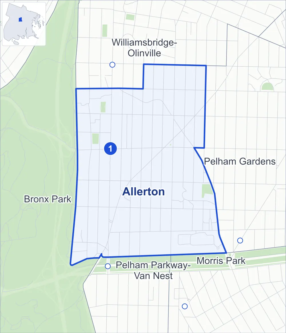
- Allerton
- A neighboring area
- Park
- A station in the list
- Another station
Neighborhood areas and streets: NYC Department of City Planning. Parks: NYC Parks. Stations: MTA.
Neighboring areas
- Williamsbridge-Olinville north
- Pelham Gardens east
- Morris Park southeast
- Pelham Parkway-Van Nest south
- Bronx Park west
Subway stations
- Allerton Av lines 2 5
Getting around
One subway station and buses on eight routes stop in or at the edge of Allerton.
- 1 subway station
- 7 local bus routes
- 1 express bus route
Local bus routes
- Bx8
- Bx25
- Bx26
- Bx30
- Bx39
- T113
- T117
Express bus route
- BxM11
Safety record
Between 2021 and 2025, its corners averaged fewer police-reported crashes than the average Bronx corner.
- 753 police-reported crashes at its corners
- 6.8 a corner, on average
- 8.0 the average Bronx corner
- 8 corners with a clean record
Signal or safety changes on City record, at 34 of its corners
- Leading pedestrian intervals
- 25
- Accessible pedestrian signals
- 17
- Barnes Dance all-way crossings
- 4
- Turn calming
- 3
- Safety Improvement Projects
- 3
Camera tickets
In 2025 its corners had more school-zone speed camera tickets than red-light or bus-lane tickets.
- 6,866 red-light camera tickets at two corners
- 9,246 school-zone speed camera tickets at 12 corners
- 0 bus-lane camera tickets
- Most red-light tickets
- Barnes Avenue & Allerton Avenue, 3,528
- Most speed tickets
- Boston Road & Waring Avenue, 1,723
People and homes
The 2020 Census counted 34,623 residents in Allerton, about 60,700 per square mile.
- 13,899 homes, 2020 Census
- 839 homes added since April 2010, net, by City Planning's count
Half of its 1,463 residential lots hold buildings from 1945 or earlier, and 46% of them date from before 1940, by the City's tax lot records.
NYCHA developments
NYCHA's Parkside development lies wholly or partly within Allerton, as does one more that NYCHA names by a building's address.
Parks and landmarks
- Parkland
- 3.3 acres of NYC Parks property
- The largest pieces
- Mazzei Playground (1.5 acres), Zimmerman Playground (1 acre) and Parkside Playground (0.8 acre)
- Designated landmark
- The Coops
Streets and trees
- Trees
- 2,113 in NYC Parks' records, most often London planetree, pin oak and thornless honeylocust
- Street with the most corners
- Boston Road, with 15 of the area's 111
- Height above sea level
- From 67 feet at Bronx Park East & Bronx River Parkway to 138 feet at Williamsbridge Road & Allerton Avenue
- Honorary street names
- 5 at its corners, enacted by local law
Schools and libraries
The City lists 14 schools and one library in Allerton.
- Public schools
- 12
- Charter and private schools
- 2
- Library
- Allerton Library
Public safety
How complaints are countedIn 2025 the NYPD recorded 622 major felonies at places in Allerton.
Recorded by the NYPD at places in Allerton
- 541 major felonies in 2024
- 1,823 other felonies, misdemeanors and violations in 2025
In 2025, on the streets along the edge of Allerton, the NYPD recorded another 169 major felonies. Counting the streets along its edge, in 2025 the NYPD recorded 22.8 major felonies for every thousand residents the 2020 Census counted in Allerton.
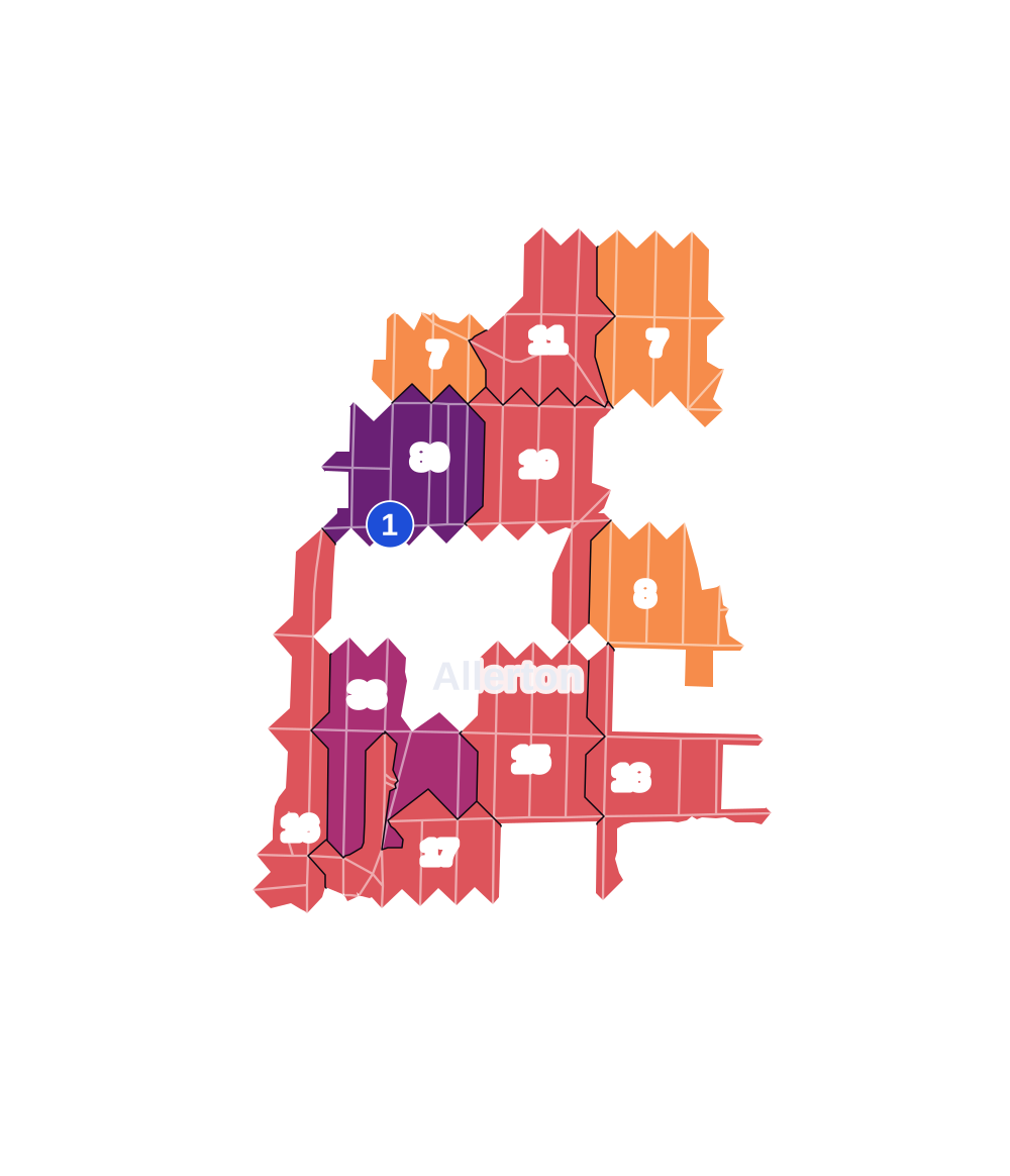
- 5 to 9
- 10 to 19
- 20 to 49
- 50 to 99
- 100 or more
- Not shaded: fewer than 5, held back under the rules in How complaints are counted, parks and public-housing grounds, and land in no patch
- Police precincts
- 49th (most of the area), 47th
From January to June 2026 the NYPD recorded 285 major felonies at places in Allerton, against 296 in the same months of 2025.
Sources: the NYPD's Complaint Data Historic, updated April 28, 2026, and Complaint Data Current (Year To Date), updated July 27, 2026, on NYC Open Data. Figures to June 30, 2026.
Street corners
- Adee Avenue & Colden Avenue
- Adee Avenue & Matthews Avenue
- Adee Avenue & Olinville Avenue
- Adee Avenue & Radcliff Avenue
- Allerton Avenue & Barker Avenue
- Allerton Avenue & Cruger Avenue
- Allerton Avenue & Matthews Avenue
- Allerton Avenue & Radcliff Avenue
- Arnow Avenue & Barker Avenue
- Arnow Avenue & Cruger Avenue
- Arnow Avenue & Matthews Avenue
- Arnow Avenue & Radcliff Avenue
- Astor Avenue & Colden Avenue
- Astor Avenue & Cruger Avenue
- Astor Avenue & Holland Avenue
- Astor Avenue & Matthews Avenue
- Astor Avenue & Nyise Driveway
- Astor Avenue & Wallace Avenue
- Astor Avenue & Williamsbridge Road
- Barker Avenue & Britton Street
- Barker Avenue & Reiss Place
- Barker Avenue & Thwaites Place
- Barnes Avenue & Adee Avenue
- Barnes Avenue & Allerton Avenue
- Barnes Avenue & Arnow Avenue
- Barnes Avenue & Astor Avenue
- Barnes Avenue & Mace Avenue
- Barnes Avenue & Waring Avenue
- Barnes Avenue & Williamsbridge Road
- Boston Road & Allerton Avenue
- Boston Road & Arnow Avenue
- Boston Road & Barnes Avenue
- Boston Road & Bronxwood Avenue
- Boston Road & Cruger Avenue
- Boston Road & Holland Avenue
- Boston Road & Mace Avenue
- Boston Road & Matthews Avenue
- Boston Road & Paulding Avenue
- Boston Road & Pelham Parkway North
- Boston Road & Radcliff Avenue
- Boston Road & Thwaites Place
- Boston Road & Wallace Avenue
- Boston Road & Waring Avenue
- Boston Road & Williamsbridge Road
- Bronx Park East & Arnow Avenue
- Bronx Park East & Britton Street
- Bronx Park East & Bronx River Parkway
- Bronx Park East & Mace Avenue
- Bronx Park East & Reiss Place
- Bronx Park East & Thwaites Place
- Bronx Park East & Waring Avenue
- Bronxwood Avenue & Adee Avenue
- Bronxwood Avenue & Allerton Avenue
- Bronxwood Avenue & Arnow Avenue
- Bronxwood Avenue & Astor Avenue
- Bronxwood Avenue & Burke Avenue
- Bronxwood Avenue & Mace Avenue
- Bronxwood Avenue & Pelham Parkway North
- Bronxwood Avenue & Waring Avenue
- Bronxwood Avenue & Williamsbridge Road
- Burke Avenue & Colden Avenue
- Burke Avenue & Matthews Avenue
- Burke Avenue & Radcliff Avenue
- Holland Avenue & Adee Avenue
- Holland Avenue & Allerton Avenue
- Holland Avenue & Arnow Avenue
- Holland Avenue & Mace Avenue
- Holland Avenue & Waring Avenue
- Mace Avenue & Barker Avenue
- Mace Avenue & Colden Avenue
- Mace Avenue & Cruger Avenue
- Mace Avenue & Matthews Avenue
- Mace Avenue & Olinville Avenue
- Mace Avenue & Radcliff Avenue
- Olinville Avenue & Allerton Avenue
- Olinville Avenue & Arnow Avenue
- Olinville Avenue & Britton Street
- Olinville Avenue & Pelham Parkway North
- Olinville Avenue & Thwaites Place
- Olinville Avenue & Waring Avenue
- Paulding Avenue & Arnow Avenue
- Paulding Avenue & Astor Avenue
- Paulding Avenue & Mace Avenue
- Paulding Avenue & Waring Avenue
- Pelham Parkway North & Barker Avenue
- Southern Boulevard & Bronx Park East
- Wallace Avenue & Adee Avenue
- Wallace Avenue & Allerton Avenue
- Wallace Avenue & Arnow Avenue
- Wallace Avenue & Mace Avenue
- Wallace Avenue & Waring Avenue
- Waring Avenue & Barker Avenue
- Waring Avenue & Colden Avenue
- Waring Avenue & Matthews Avenue
- White Plains Road & Allerton Avenue
- White Plains Road & Arnow Avenue
- White Plains Road & Britton Street
- White Plains Road & Mace Avenue
- White Plains Road & Thwaites Place
- White Plains Road & Waring Avenue
- Williamsbridge Road & Adee Avenue
- Williamsbridge Road & Allerton Avenue
- Williamsbridge Road & Arnow Avenue
- Williamsbridge Road & Cruger Avenue
- Williamsbridge Road & Holland Avenue
- Williamsbridge Road & Hone Avenue
- Williamsbridge Road & Matthews Avenue
- Williamsbridge Road & Nyise Driveway
- Williamsbridge Road & Radcliff Avenue
- Williamsbridge Road & Wallace Avenue
- Williamsbridge Road & Waring Avenue
How the figures above are measured: Methodology.