Pelham Gardens
Neighborhood · Bronx
Pelham Gardens lies in the northeast Bronx just north of Pelham Parkway, with East Gun Hill Road along its northern and eastern sides.
- 1.08 square miles
- 29,402 residents, 2020 Census
- 204 street corners
- 2 subway stations
- 9 bus routes
It is named for Thomas Pell, who bought land here from the Siwanoy people in 1654. Building began in earnest in the 1920s and was followed by a boom in the 1950s, leaving streets of mostly one-family houses mixed with two- and three-family homes and small apartment buildings. Along its southern edge runs the Bronx and Pelham Parkway, built in the late 19th century to connect Bronx Park with Pelham Bay Park.
Sources: Pelham Gardens, Bronx (Wikipedia); Pelham Bay Park (NYC Parks); Pelham Parkway (NYC Parks); About (Bronx Community Board 11).
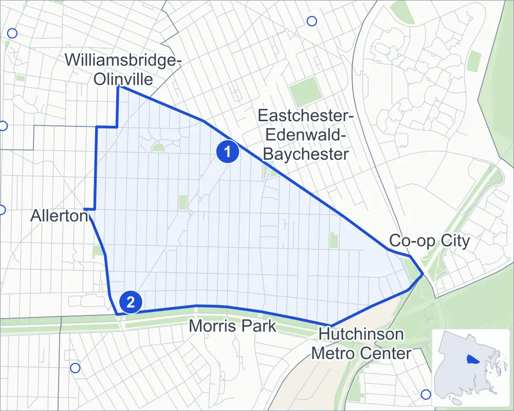
Pelham Gardens borders six areas, and Waring Avenue holds more of its corners than any other street, 30 of 204.
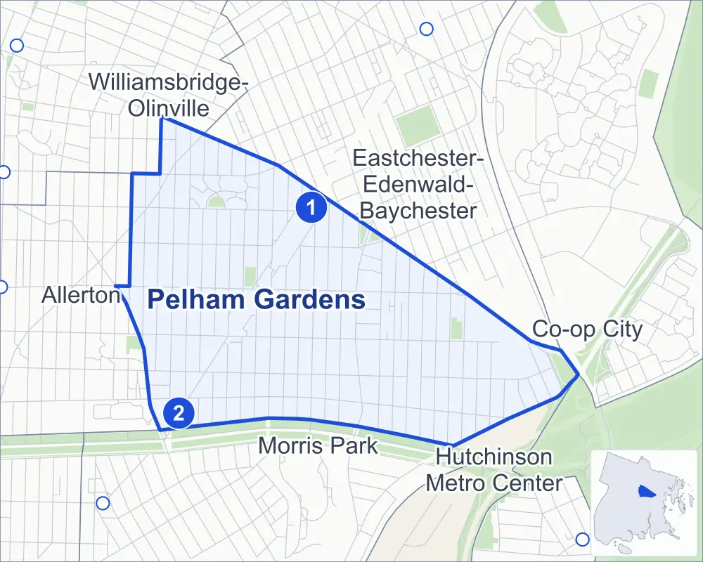
- Pelham Gardens
- A neighboring area
- Park
- A station in the list
- Another station
Neighborhood areas and streets: NYC Department of City Planning. Parks: NYC Parks. Stations: MTA.
Neighboring areas
- Eastchester-Edenwald-Baychester northeast
- Co-op City east
- Hutchinson Metro Center southeast
- Morris Park south
- Allerton west
- Williamsbridge-Olinville northwest
Subway stations
- Gun Hill Rd lines 5 accessible
- Pelham Pkwy lines 5
Getting around
Two subway stations and buses on nine routes stop in or at the edge of Pelham Gardens.
- 2 subway stations
- 1 of them listed by the MTA as fully accessible
- 8 local bus routes
- 1 express bus route
Local bus routes
- Bx8
- Bx25
- Bx26
- Bx28
- Bx30
- Bx31
- Bx38
- T113
Express bus route
- BxM10
Safety record
Between 2021 and 2025, its corners averaged fewer police-reported crashes than the average Bronx corner.
- 599 police-reported crashes at its corners
- 2.9 a corner, on average
- 8.0 the average Bronx corner
- 47 corners with a clean record
Signal or safety changes on City record, at 17 of its corners
- Accessible pedestrian signals
- 16
- Leading pedestrian intervals
- 10
- Turn calming
- 2
- Barnes Dance all-way crossings
- 1
Camera tickets
In 2025 its corners had more school-zone speed camera tickets than red-light or bus-lane tickets.
- 69 red-light camera tickets at one corner
- 24,143 school-zone speed camera tickets at 23 corners
- 0 bus-lane camera tickets
- Most red-light tickets
- Williamsbridge Road & Pelham Parkway North, 69
- Most speed tickets
- East Gun Hill Road & Gunther Avenue at Allerton Avenue, 5,173
People and homes
The 2020 Census counted 29,402 residents in Pelham Gardens, about 27,200 per square mile.
- 9,951 homes, 2020 Census
- 201 homes added since April 2010, net, by City Planning's count
Half of its 4,963 residential lots hold buildings from 1950 or earlier, and 21% of them date from before 1940, by the City's tax lot records.
Parks
- Parkland
- 5.6 acres of NYC Parks property
- The largest pieces
- Burns Playground (1.7 acres), Allerton Playground (1.6 acres) and Givan Square (1.2 acres)
Streets and trees
- Trees
- 3,910 in NYC Parks' records, most often London planetree, pin oak and Callery pear
- Street with the most corners
- Waring Avenue, with 30 of the area's 204
- Height above sea level
- From 13 feet at Waring Avenue & Wickham Avenue to 142 feet at Laconia Avenue & Allerton Avenue
- Honorary street names
- 2 at its corners, enacted by local law
Schools
The City lists seven schools in Pelham Gardens.
- Public schools
- 4
- Charter and private schools
- 3
Public safety
How complaints are countedIn 2025 the NYPD recorded 402 major felonies at places in Pelham Gardens.
Recorded by the NYPD at places in Pelham Gardens
- 398 major felonies in 2024
- 942 other felonies, misdemeanors and violations in 2025
In 2025, on the streets along the edge of Pelham Gardens, the NYPD recorded another 131 major felonies. Counting the streets along its edge, in 2025 the NYPD recorded 18.1 major felonies for every thousand residents the 2020 Census counted in Pelham Gardens.
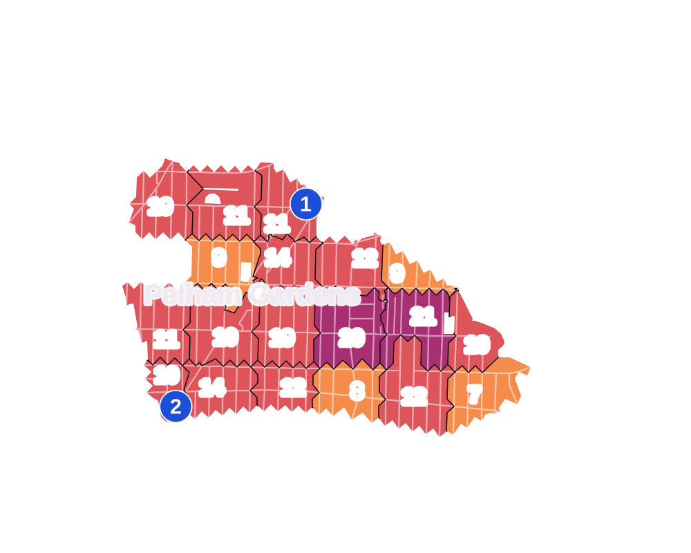
- 5 to 9
- 10 to 19
- 20 to 49
- 50 to 99
- 100 or more
- Not shaded: fewer than 5, held back under the rules in How complaints are counted, parks and public-housing grounds, and land in no patch
- Police precincts
- 49th (most of the area), 47th
From January to June 2026 the NYPD recorded 174 major felonies at places in Pelham Gardens, against 188 in the same months of 2025.
Sources: the NYPD's Complaint Data Historic, updated April 28, 2026, and Complaint Data Current (Year To Date), updated July 27, 2026, on NYC Open Data. Figures to June 30, 2026.
Street corners
- Adee Avenue & Bouck Avenue
- Adee Avenue & Hering Avenue
- Adee Avenue & Hone Avenue
- Adee Avenue & Laconia Avenue
- Adee Avenue & Lurting Avenue
- Adee Avenue & Pearsall Avenue
- Adee Avenue & Sexton Place
- Adee Avenue & Tenbroeck Avenue
- Adee Avenue & Throop Avenue
- Adee Avenue & Wilson Avenue
- Adee Avenue & Yates Avenue
- Adee Avenue & Young Avenue
- Allerton Avenue & Fenton Avenue
- Allerton Avenue & Fish Avenue
- Allerton Avenue & Hering Avenue
- Allerton Avenue & Kingsland Avenue
- Allerton Avenue & Lodovick Avenue
- Allerton Avenue & Mickle Avenue
- Allerton Avenue & Morgan Avenue
- Allerton Avenue & Pearsall Avenue
- Allerton Avenue & Seymour Avenue
- Allerton Avenue & Tenbroeck Avenue
- Allerton Avenue & Throop Avenue
- Allerton Avenue & Tiemann Avenue
- Allerton Avenue & Westervelt Avenue
- Allerton Avenue & Wilson Avenue
- Allerton Avenue & Woodhull Avenue
- Allerton Avenue & Yates Avenue
- Allerton Avenue & Young Avenue
- Arnow Avenue & Bouck Avenue
- Arnow Avenue & Fenton Avenue
- Arnow Avenue & Fish Avenue
- Arnow Avenue & Hering Avenue
- Arnow Avenue & Morgan Avenue
- Arnow Avenue & O'Neill Place
- Arnow Avenue & Pearsall Avenue
- Arnow Avenue & Seymour Avenue
- Arnow Avenue & Tenbroeck Avenue
- Arnow Avenue & Throop Avenue
- Arnow Avenue & Wilson Avenue
- Arnow Avenue & Woodhull Avenue
- Arnow Avenue & Yates Avenue
- Astor Avenue & Bouck Avenue
- Astor Avenue & Bruner Avenue
- Astor Avenue & Delanoy Avenue
- Astor Avenue & Esplanade
- Astor Avenue & Fenton Avenue
- Astor Avenue & Fish Avenue
- Astor Avenue & Gunther Avenue
- Astor Avenue & Hering Avenue
- Astor Avenue & Kingsland Avenue
- Astor Avenue & Laconia Avenue
- Astor Avenue & Lodovick Avenue
- Astor Avenue & Mickle Avenue
- Astor Avenue & Morgan Avenue
- Astor Avenue & Pearsall Avenue
- Astor Avenue & Seymour Avenue
- Astor Avenue & Tenbroeck Avenue
- Astor Avenue & Throop Avenue
- Astor Avenue & Tiemann Avenue
- Astor Avenue & Westervelt Avenue
- Astor Avenue & Wickham Avenue
- Astor Avenue & Wilson Avenue
- Astor Avenue & Woodhull Avenue
- Astor Avenue & Yates Avenue
- Astor Avenue & Young Avenue
- Boston Road & Adee Avenue
- Boston Road & Burke Avenue
- Boston Road & Hone Avenue
- Boston Road & Laconia Avenue
- Boston Road & Lurting Avenue
- Boston Road & Yates Avenue
- Bouck Avenue & Gabriel Drive
- Bouck Avenue & Stedman Place
- Bruner Avenue & Stillwell Avenue
- Burke Avenue & Bouck Avenue
- Burke Avenue & Hering Avenue
- Burke Avenue & Pearsall Avenue
- Burke Avenue & Tenbroeck Avenue
- Burke Avenue & Throop Avenue
- Burke Avenue & Wilson Avenue
- Burke Avenue & Yates Avenue
- Dewitt Place & Stedman Place
- East Gun Hill Road & Allerton Avenue
- East Gun Hill Road & Edson Avenue
- East Gun Hill Road & Ely Avenue
- East Gun Hill Road & Fenton Avenue
- East Gun Hill Road & Gunther Avenue
- East Gun Hill Road & Gunther Avenue at Allerton Avenue
- East Gun Hill Road & Laconia Avenue
- East Gun Hill Road & Mickle Avenue
- East Gun Hill Road & New England Thruway
- East Gun Hill Road & Sexton Place
- East Gun Hill Road & Throop Avenue
- East Gun Hill Road & Tiemann Avenue
- East Gun Hill Road & Waring Avenue
- East Gun Hill Road & Yates Avenue
- Eastchester Road & Allerton Avenue
- Eastchester Road & Arnow Avenue
- Eastchester Road & Astor Avenue
- Eastchester Road & Bantam Place
- Eastchester Road & Fielding Street
- Eastchester Road & Hawthorne Street
- Eastchester Road & Mace Avenue
- Eastchester Road & Pelham Parkway North
- Eastchester Road & Schorr Place
- Eastchester Road & Waring Avenue
- Ely Avenue & Stillwell Avenue
- Ely Avenue & Waring Avenue
- Fish Avenue & Sexton Place
- Gunther Avenue & Allerton Avenue
- Gunther Avenue & Mace Avenue
- Gunther Avenue & Waring Avenue
- Hone Avenue & Allerton Avenue
- Hone Avenue & Arnow Avenue
- Hone Avenue & Mace Avenue
- Laconia Avenue & Allerton Avenue
- Laconia Avenue & Arnow Avenue
- Laconia Avenue & Burke Avenue
- Laconia Avenue & Duncan Street
- Laconia Avenue & Mace Avenue
- Laconia Avenue & Pelham Parkway North
- Laconia Avenue & Stell Place
- Laconia Avenue & Waring Avenue
- Lurting Avenue & Allerton Avenue
- Lurting Avenue & Arnow Avenue
- Lurting Avenue & Burke Avenue
- Mace Avenue & Bouck Avenue
- Mace Avenue & Delanoy Avenue
- Mace Avenue & Fenton Avenue
- Mace Avenue & Fish Avenue
- Mace Avenue & Gabriel Drive
- Mace Avenue & Hering Avenue
- Mace Avenue & Kingsland Avenue
- Mace Avenue & Lodovick Avenue
- Mace Avenue & Lurting Avenue
- Mace Avenue & Mickle Avenue
- Mace Avenue & Morgan Avenue
- Mace Avenue & Pearsall Avenue
- Mace Avenue & Seymour Avenue
- Mace Avenue & Tenbroeck Avenue
- Mace Avenue & Throop Avenue
- Mace Avenue & Tiemann Avenue
- Mace Avenue & Westervelt Avenue
- Mace Avenue & Wickham Avenue
- Mace Avenue & Wilson Avenue
- Mace Avenue & Woodhull Avenue
- Mace Avenue & Yates Avenue
- Mace Avenue & Young Avenue
- Morgan Avenue & Dewitt Place
- Paulding Avenue & Adee Avenue
- Paulding Avenue & Allerton Avenue
- Paulding Avenue & Williamsbridge Road
- Pearsall Avenue & Esplanade
- Pearsall Avenue & Stedman Place
- Pelham Parkway North & Fenton Avenue
- Pelham Parkway North & Fish Avenue
- Pelham Parkway North & Hering Avenue
- Pelham Parkway North & Lodovick Avenue
- Pelham Parkway North & Morgan Avenue
- Pelham Parkway North & Stillwell Avenue
- Pelham Parkway North & Throop Avenue
- Pelham Parkway North & Westervelt Avenue
- Pelham Parkway North & Woodhull Avenue
- Pelham Parkway North & Young Avenue
- Seymour Avenue & Dewitt Place
- Stillwell Avenue & Delanoy Avenue
- Stillwell Avenue & Demeyer Street
- Waring Avenue & Bouck Avenue
- Waring Avenue & Bruner Avenue
- Waring Avenue & Delanoy Avenue
- Waring Avenue & Demeyer Street
- Waring Avenue & Esplanade
- Waring Avenue & Fenton Avenue
- Waring Avenue & Fish Avenue
- Waring Avenue & Hering Avenue
- Waring Avenue & Kingsland Avenue
- Waring Avenue & Lodovick Avenue
- Waring Avenue & Lurting Avenue
- Waring Avenue & Mickle Avenue
- Waring Avenue & Morgan Avenue
- Waring Avenue & Pearsall Avenue
- Waring Avenue & Seymour Avenue
- Waring Avenue & Tenbroeck Avenue
- Waring Avenue & Throop Avenue
- Waring Avenue & Tiemann Avenue
- Waring Avenue & Vance Street
- Waring Avenue & Westervelt Avenue
- Waring Avenue & Wickham Avenue
- Waring Avenue & Wilson Avenue
- Waring Avenue & Woodhull Avenue
- Waring Avenue & Yates Avenue
- Waring Avenue & Young Avenue
- Williamsbridge Road & Mace Avenue
- Williamsbridge Road & Pelham Parkway North
- Williamsbridge Road & Stell Place
- Wilson Avenue & Sexton Place
- Wilson Avenue & Stedman Place
- Woodhull Avenue & Bantam Place
- Woodhull Avenue & Fielding Street
- Woodhull Avenue & Hawthorne Street
- Woodhull Avenue & Schorr Place
- Young Avenue & Dewitt Place
- Young Avenue & Sexton Place
How the figures above are measured: Methodology.