Co-op City
Neighborhood · Bronx
Co-op City covers some 320 acres of the northeast Bronx, framed by Interstate 95 and the Hutchinson River Parkway on land that spans parts of Baychester and Eastchester.
- 1.04 square miles
- 37,369 residents, 2020 Census
- 80 street corners
- 11 bus routes
The site was marshland before the Freedomland U.S.A. amusement park operated there from 1960 to 1964. The United Housing Foundation sponsored its construction, which began in 1966; the first residents moved in during December 1968, and the work was finished in 1973. Its 15,372 apartments, in 35 high-rise towers and seven townhouse clusters, make it the largest housing cooperative in the world, served by three shopping centers and a 25-acre educational park.
Sources: Co-op City, Bronx (Wikipedia); About BXCB10 (Bronx Community Board 10).
Co-op City borders three areas, and New England Thruway holds more of its corners than any other street, 17 of 80.
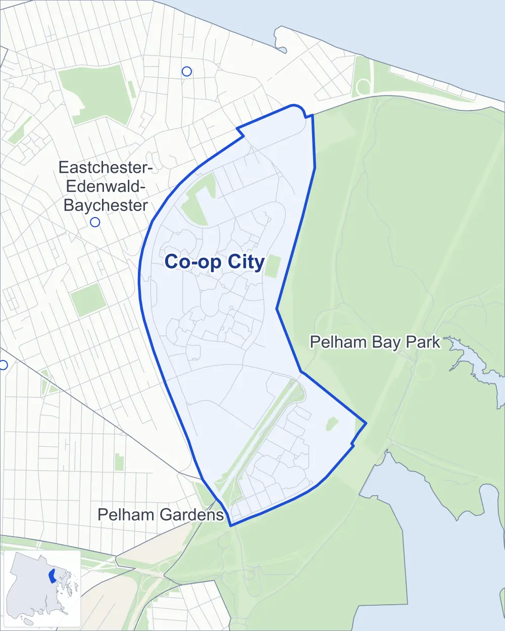
- Co-op City
- A neighboring area
- Park
- Another station
Neighborhood areas and streets: NYC Department of City Planning. Parks: NYC Parks. Stations: MTA.
Neighboring areas
- Pelham Bay Park southeast
- Pelham Gardens south
- Eastchester-Edenwald-Baychester northwest
Getting around
Buses on 11 routes stop in or at the edge of Co-op City.
- 10 local bus routes
- 1 express bus route
Local bus routes
- Bx5
- Bx12
- Bx12-SBS
- Bx23
- Bx25
- Bx26
- Bx28
- Bx30
- Bx38
- Q50
Express bus route
- BxM7
Safety record
Between 2021 and 2025, its corners averaged fewer police-reported crashes than the average Bronx corner.
- 504 police-reported crashes at its corners
- 6.3 a corner, on average
- 8.0 the average Bronx corner
- 14 corners with a clean record
Signal or safety changes on City record, at 17 of its corners
- Accessible pedestrian signals
- 14
- Leading pedestrian intervals
- 13
- Turn calming
- 1
- Barnes Dance all-way crossings
- 1
Camera tickets
In 2025 its corners had more school-zone speed camera tickets than red-light or bus-lane tickets.
- 1,486 red-light camera tickets at one corner
- 22,263 school-zone speed camera tickets at four corners
- 0 bus-lane camera tickets
- Most red-light tickets
- Co-Op City Boulevard & Bartow Avenue, 1,486
- Most speed tickets
- New England Thruway & Reeds Mill Lane, 16,213
People and homes
The 2020 Census counted 37,369 residents in Co-op City, about 35,900 per square mile.
- 17,921 homes, 2020 Census
- 256 homes added since April 2010, net, by City Planning's count
Half of its 94 residential lots hold buildings from 1948 or earlier, and 49% of them date from before 1940, by the City's tax lot records.
Parks
- Parkland
- 16.4 acres of NYC Parks property
- The largest pieces
- Givans Creek Woods (10.1 acres), Co-op City Field (3.4 acres) and Pelham Bay Park (2.9 acres)
Streets and trees
- Trees
- 1,772 in NYC Parks' records, most often London planetree, thornless honeylocust and pin oak
- Street with the most corners
- New England Thruway, with 17 of the area's 80
- Height above sea level
- From 12 feet at Hutchinson River Parkway East & Boller Avenue to 37 feet at Baychester Avenue & Donizetti Place
- Honorary street names
- 4 at its corners, enacted by local law
Schools and libraries
The City lists 11 schools and one library in Co-op City.
- Public schools
- 9
- Charter and private schools
- 2
- Library
- Baychester Library
Public safety
How complaints are countedIn 2025 the NYPD recorded 430 major felonies at places in Co-op City.
Recorded by the NYPD at places in Co-op City
- 420 major felonies in 2024
- 954 other felonies, misdemeanors and violations in 2025
In 2025, on the streets along the edge of Co-op City, the NYPD recorded another 20 major felonies.
- Police precincts
- 45th (most of the area), 47th
From January to June 2026 the NYPD recorded 235 major felonies at places in Co-op City, against 219 in the same months of 2025.
Sources: the NYPD's Complaint Data Historic, updated April 28, 2026, and Complaint Data Current (Year To Date), updated July 27, 2026, on NYC Open Data. Figures to June 30, 2026.
Street corners
- Adler Place & Asch Loop
- Asch Loop & Alcott Place
- Asch Loop & Aldrich Street
- Bartow Avenue & Asch Loop
- Bartow Avenue & Bay Plaza Driveway
- Baychester Avenue & Bartow Avenue
- Baychester Avenue & Bay Plaza Driveway
- Baychester Avenue & Co-Op City Boulevard
- Baychester Avenue & Darrow Place
- Baychester Avenue & Donizetti Place
- Baychester Avenue & New England Thruway
- Baychester Avenue & New England Thruway (Exit 11)
- Bellamy Loop & Benchley Place
- Boller Avenue & Erskine Place
- Boller Avenue & Hunter Avenue
- Broun Place & Bellamy Loop
- Carver Loop & Casals Place
- Carver Loop & Cooper Place
- Co-Op City Boulevard & Asch Loop
- Co-Op City Boulevard & Bartow Avenue
- Co-Op City Boulevard & Bay Plaza Driveway
- Co-Op City Boulevard & Bellamy Loop (north)
- Co-Op City Boulevard & Bellamy Loop (south)
- Co-Op City Boulevard & Carver Loop
- Co-Op City Boulevard & Dreiser Loop (east)
- Co-Op City Boulevard & Dreiser Loop (west)
- Co-Op City Boulevard & Peartree Avenue
- Co-Op City Boulevard & Rombouts Avenue
- De Reimer Avenue & Bassett Avenue
- De Reimer Avenue & Erskine Place
- Debs Place & Dreiser Loop
- Dreiser Loop & De Kruif Place
- Dreiser Loop & Defoe Place
- Einstein Loop South & Erdman Place
- Elgar Place & Einstein Loop South
- Erskine Place & Earhart Lane
- Erskine Place & Hunter Avenue
- Givan Avenue & Conner Street
- Givan Avenue & Conner Street at Peartree Avenue
- Givan Avenue & De Lavall Avenue
- Givan Avenue & Merritt Avenue
- Givan Avenue & Rombouts Avenue
- Hollers Avenue & Heathcote Avenue
- Hollers Avenue & Hutchinson Avenue
- Hollers Avenue & New England Thruway
- Hollers Avenue & Noell Avenue
- Hollers Avenue & Pinkney Avenue
- Hunter Avenue & Earhart Lane
- Hutchinson River Parkway & New England Thruway
- Hutchinson River Parkway & New England Thruway (Exit 2A)
- Hutchinson River Parkway Bridge & Hutchinson River Parkway East
- Hutchinson River Parkway East & Boller Avenue
- Hutchinson River Parkway East & Einstein Loop North
- Hutchinson River Parkway East & Einstein Loop South
- Hutchinson River Parkway East & Hutchinson River Parkway
- New England Thruway & Bartow Avenue
- New England Thruway & Conner Street
- New England Thruway & East 222nd Street Pedestrian Overpass
- New England Thruway & Erskine Place
- New England Thruway & Givan Avenue
- New England Thruway & Hunter Avenue
- New England Thruway & New England Thrwy (Exit 10)
- New England Thruway & New England Thrwy (Exit 12)
- New England Thruway & Reeds Mill Lane
- New England Thruway & Tillotson Avenue Pedestrian Overpass
- Palmer Avenue & Bruckner Expressway
- Palmer Avenue & Erskine Place
- Palmer Avenue & Hutchinson River Parkway
- Stillwell Avenue & Boller Avenue
- Stillwell Avenue & Hunter Avenue
- Stillwell Avenue & Palmer Avenue
- Tillotson Avenue & Conner Street
- Tillotson Avenue & Conner Street at Provost Avenue
- Tillotson Avenue & De Lavall Avenue
- Tillotson Avenue & Merritt Avenue
- Tillotson Avenue & Net
- Tillotson Avenue & New England Thruway
- Tillotson Avenue & Noell Avenue
- Tillotson Avenue & Rombouts Avenue
- Tillotson Avenue & Tillotson Avenue Pedestrian Overpass
How the figures above are measured: Methodology.