Pelham Bay Park
Park · Bronx
Pelham Bay Park fills the northeast corner of the Bronx along Long Island Sound and, at 2,772 acres, is New York City's largest park, more than three times the size of Central Park.
- 3.56 square miles
- 51 street corners
- 12 bus routes
In 1654 Thomas Pell bought some 50,000 acres from the Siwanoy, including the park's land, which became known as Pelham Manor after a 1666 royal charter; it became a city park in 1888 and is run by NYC Parks. In the 1930s the city linked Hunter Island and Rodman's Neck with dredged sand to make Orchard Beach, and the park also holds the Bartow-Pell Mansion of 1842, two golf courses and about 13 miles of shoreline.
Sources: Pelham Bay Park (NYC Parks); Pelham Bay Park (Wikipedia).
Pelham Bay Park borders five areas, and Bruckner Expressway holds more of its corners than any other street, 17 of 51.
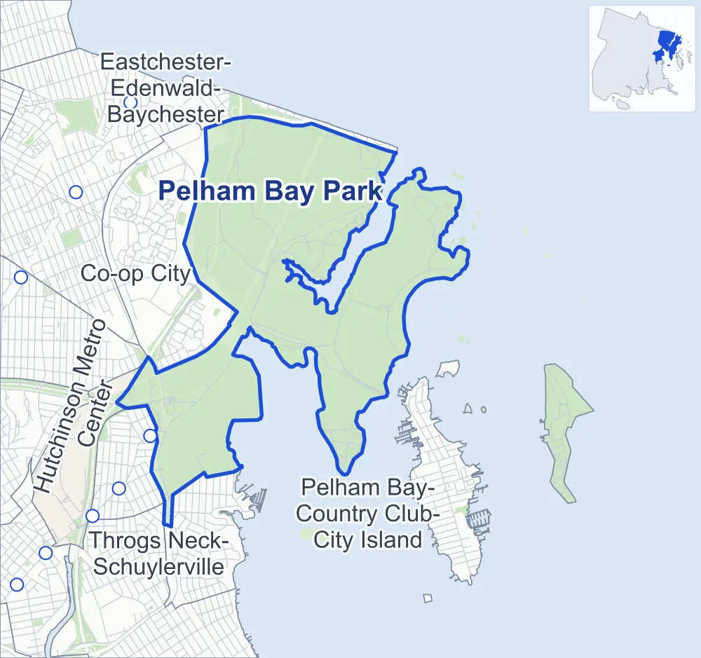
- Pelham Bay Park
- A neighboring area
- Park
- Another station
Neighborhood areas and streets: NYC Department of City Planning. Parks: NYC Parks. Stations: MTA.
Neighboring areas
- Eastchester-Edenwald-Baychester north
- Pelham Bay-Country Club-City Island southwest
- Hutchinson Metro Center southwest
- Throgs Neck-Schuylerville southwest
- Co-op City west
Getting around
Buses on 12 routes stop in or at the edge of Pelham Bay Park.
- 11 local bus routes
- 1 express bus route
Local bus routes
- Bx5
- Bx12
- Bx12-SBS
- Bx23
- Bx24
- Bx26
- Bx28
- Bx29
- Bx30
- Q50
- T103
Express bus route
- BxM8
Safety record
Between 2021 and 2025, its corners averaged fewer police-reported crashes than the average Bronx corner.
- 272 police-reported crashes at its corners
- 5.3 a corner, on average
- 8.0 the average Bronx corner
- 36 corners with a clean record
Signal or safety changes on City record, at six of its corners
- Accessible pedestrian signals
- 6
- Barnes Dance all-way crossings
- 1
Camera tickets
In 2025 the Department of Finance recorded no red-light, school-zone speed or bus-lane camera ticket at its corners.
Parks and landmarks
- Parkland
- 2045.7 acres of Pelham Bay Park, as NYC Parks maps it within the area's boundary
- Designated landmark
- The Orchard Beach Bathhouse
Streets and trees
- Trees
- 4,565 in NYC Parks' records, most often pin oak, sweetgum and northern red oak
- Street with the most corners
- Bruckner Expressway, with 17 of the area's 51
- Height above sea level
- From 6 feet at Park Drive & Orchard Beach Mall to 39 feet at Bruckner Boulevard & Charles J Crimi Road at Wilkinson Avenue
Public art
The City's public art inventory lists one work in Pelham Bay Park: American Boy (1932).
- 1 work of public art
Street corners
- Bruckner Boulevard & Bruckner Expressway
- Bruckner Boulevard & Buhre Avenue Pedestrian Overpass
- Bruckner Boulevard & Charles J Crimi Road at Pelham Parkway
- Bruckner Boulevard & Charles J Crimi Road at Wilkinson Avenue
- Bruckner Boulevard & Middletown Road at Roberts Avenue Pedestrian Overpass
- Bruckner Boulevard & Westchester Avenue
- Bruckner Boulevard & Westchester Avenue at Bruckner Expressway
- Bruckner Boulevard & Westchester Avenue Pedestrian Overpass
- Bruckner Expressway & Buhre Avenue Pedestrian Overpass
- Bruckner Expressway & Pelham Parkway
- Bruckner Expressway & Roberts Avenue Pedestrian Overpass
- Bruckner Expressway & Westchester Avenue
- Bruckner Expressway & Westchester Avenue Pedestrian Overpass
- Bruckner Expressway & Wilkinson Avenue
- Charles J Crimi Road & Bruckner Expressway
- Charles J Crimi Road & Bruckner Expressway at Pelham Parkway (east)
- Charles J Crimi Road & Bruckner Expressway at Pelham Parkway (north-east)
- Charles J Crimi Road & Bruckner Expressway at Pelham Parkway (south-west)
- Charles J Crimi Road & Pelham Parkway
- Charles J Crimi Road & Pelham Parkway at Bruckner Expressway
- City Island Bridge & City Island Road
- City Island Road & Pelham Bay Park Headquarters Driveway
- Hutchinson River Parkway & Bartow Circle
- Hutchinson River Parkway & Hutchinson Parkway
- Hutchinson River Parkway & Pelham Bay Park Bridle Trail
- Hutchinson River Parkway & Pelham Bay Park Bridle Trail (Exit 3)
- Hutchinson River Parkway & Pelham Parkway
- Orchard Beach Boardwalk & Kazimiroff Nature Trail
- Orchard Beach Boardwalk & Orchard Beach Boardwalk Connector
- Orchard Beach Mall & Orchard Beach Boardwalk Connector
- Orchard Beach Road & Bartow Circle
- Park Drive & City Island Road
- Park Drive & City Island Road at Orchard Beach Circle
- Park Drive & Orchard Beach Bus Terminal Loop (north)
- Park Drive & Orchard Beach Bus Terminal Loop (south)
- Park Drive & Orchard Beach Circle (north-east)
- Park Drive & Orchard Beach Circle (south-west)
- Park Drive & Orchard Beach Mall (north-east)
- Park Drive & Orchard Beach Mall (south-west)
- Park Drive & Rodmans Neck Path
- Pelham Bridge & Shore Road
- Pelham Parkway & Bruckner Expressway (east)
- Pelham Parkway & Bruckner Expressway (west)
- Pelham Parkway & Pelhambruck
- Shore Road & Bartow Circle (north-east)
- Shore Road & Bartow Circle (south-west)
- Shore Road & City Island Road
- Shore Road & Hutchinson River Parkway
- Shore Road & Pelham Bay Park Bridle Trail
- Shore Road & Pelham Bay Park Bridle Trail at Pelham Bay Park Siwanoy Trail
- Shore Road & Pelham Parkway
How the figures above are measured: Methodology.