Throgs Neck-Schuylerville
Neighborhood · Bronx
Throgs Neck-Schuylerville covers the Throgs Neck peninsula in the southeast Bronx, along with Edgewater Park and Schuylerville, which lies between the Bruckner Expressway and the Hutchinson River Parkway.
- 2.38 square miles
- 48,116 residents, 2020 Census
- 522 street corners
- 1 subway station
- 9 bus routes
The neck takes its name from John Throckmorton, an English immigrant whom the Dutch allowed to settle here with 35 others in 1642, and its large estates gave way to row houses and bungalow lots in the 1920s. East of the Throgs Neck Bridge stands Fort Schuyler, built from 1833 to 1856 to guard the point where Long Island Sound enters the East River; a city landmark since 1966, it has housed a maritime academy, now SUNY Maritime College, since the 1930s.
Sources: Throggs Neck, Bronx (Wikipedia); Schuylerville, Bronx (Wikipedia); Fort Schuyler, State University of New York Maritime College (LP-0124), Number 2, April 19, 1966 (NYC Landmarks Preservation Commission); About BXCB10 (Bronx Community Board 10).
Throgs Neck-Schuylerville borders six areas, and East Tremont Avenue holds more of its corners than any other street, 40 of 522.
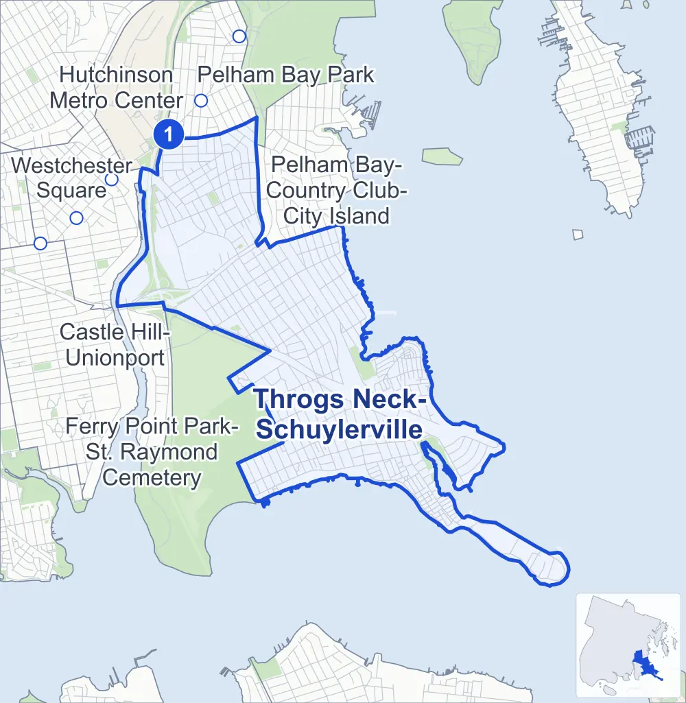
- Throgs Neck-Schuylerville
- A neighboring area
- Park
- A station in the list
- Another station
Neighborhood areas and streets: NYC Department of City Planning. Parks: NYC Parks. Stations: MTA.
Neighboring areas
- Pelham Bay-Country Club-City Island north
- Pelham Bay Park north
- Ferry Point Park-St. Raymond Cemetery southwest
- Castle Hill-Unionport west
- Hutchinson Metro Center northwest
- Westchester Square northwest
Subway stations
- Middletown Rd lines 6
Getting around
One subway station and buses on nine routes stop in or at the edge of Throgs Neck-Schuylerville.
- 1 subway station
- 7 local bus routes
- 2 express bus routes
Local bus routes
- Bx5
- Bx8
- Bx24
- Bx40
- Bx42
- Q50
- T103
Express bus routes
- BxM8
- BxM9
Safety record
Between 2021 and 2025, its corners averaged fewer police-reported crashes than the average Bronx corner.
- 1,097 police-reported crashes at its corners
- 2.1 a corner, on average
- 8.0 the average Bronx corner
- 248 corners with a clean record
Signal or safety changes on City record, at 25 of its corners
- Leading pedestrian intervals
- 21
- Accessible pedestrian signals
- 10
- Turn calming
- 3
- Barnes Dance all-way crossings
- 1
- Safety Improvement Projects
- 1
Camera tickets
In 2025 its corners had more school-zone speed camera tickets than red-light or bus-lane tickets.
- 0 red-light camera tickets
- 32,737 school-zone speed camera tickets at 18 corners
- 0 bus-lane camera tickets
- Most speed tickets
- Bruckner Boulevard & Revere Avenue, 21,588
People and homes
The 2020 Census counted 48,116 residents in Throgs Neck-Schuylerville, about 20,200 per square mile.
- 18,770 homes, 2020 Census
- 245 homes added since April 2010, net, by City Planning's count
Half of its 7,580 residential lots hold buildings from 1950 or earlier, and 43% of them date from before 1940, by the City's tax lot records.
NYCHA developments
NYCHA's Throggs Neck and Throggs Neck Addition developments lie wholly or partly within Throgs Neck-Schuylerville, as does one more that NYCHA names by a building's address.
Parks and landmarks
- Parkland
- 12.8 acres of NYC Parks property
- The largest pieces
- Bicentennial Veterans Memorial Park (9.5 acres), Bufano Park (1.9 acres) and Bruckner Playground (1 acre)
- Designated landmark
- The Fort Schuyler
Streets and trees
- Trees
- 6,267 in NYC Parks' records, most often London planetree, thornless honeylocust and pin oak
- Street with the most corners
- East Tremont Avenue, with 40 of the area's 522
- Height above sea level
- From 4 feet at 1st Avenue & Sound View Street to 56 feet at East Tremont Avenue & Otis Avenue
- Honorary street names
- 23 at its corners, enacted by local law
Schools and libraries
The City lists 20 schools and two libraries in Throgs Neck-Schuylerville.
- Public schools
- 17
- Charter and private schools
- 3
- Libraries
- Pelham Bay Library and Throg's Neck Library
Public safety
How complaints are countedIn 2025 the NYPD recorded 664 major felonies at places in Throgs Neck-Schuylerville.
Recorded by the NYPD at places in Throgs Neck-Schuylerville
- 551 major felonies in 2024
- 1,860 other felonies, misdemeanors and violations in 2025
In 2025, on the streets along the edge of Throgs Neck-Schuylerville, the NYPD recorded another 75 major felonies. Counting the streets along its edge, in 2025 the NYPD recorded 15.4 major felonies for every thousand residents the 2020 Census counted in Throgs Neck-Schuylerville.
- Police precinct
- 45th
From January to June 2026 the NYPD recorded 237 major felonies at places in Throgs Neck-Schuylerville, against 331 in the same months of 2025.
Sources: the NYPD's Complaint Data Historic, updated April 28, 2026, and Complaint Data Current (Year To Date), updated July 27, 2026, on NYC Open Data. Figures to June 30, 2026.
Street corners
- 1st Avenue & Centre Street
- 1st Avenue & Dock Street
- 1st Avenue & Edge Street
- 1st Avenue & Main Street
- 1st Avenue & Pennyfield Avenue
- 1st Avenue & Sound View Street
- 3rd Avenue & 1st Avenue
- 3rd Avenue & Centre Street
- 3rd Avenue & Dock Street
- 3rd Avenue & Edge Street
- 3rd Avenue & Main Street
- 3rd Avenue & Pennyfield Avenue
- 4th Avenue & Centre Street
- 4th Avenue & Main Street
- 5th Avenue & 6th Avenue
- 5th Avenue & Centre Street
- 5th Avenue & Edge Street
- 5th Avenue & Main Street (east)
- 5th Avenue & Main Street (west)
- 5th Avenue & Pennyfield Avenue
- 5th Avenue & Sampson Avenue
- 7th Avenue & 9th Avenue
- 7th Avenue & Edge Street
- 7th Avenue & Main Street
- 7th Avenue & Pennyfield Avenue
- 9th Avenue & Centre Edgewater Park Drive
- 9th Avenue & Edge Street
- 9th Avenue & Main Street
- 9th Avenue & Pennyfield Avenue
- 11th Avenue & Edge Street
- 11th Avenue & Sampson Avenue
- Adee Avenue & 9th Avenue
- Adee Avenue & 12th Avenue
- Adee Avenue & 13th Avenue
- Adee Avenue & Meagher Avenue
- Adee Avenue & Pennyfield Avenue
- Adee Avenue & Prentiss Avenue
- B Street & Baisley Avenue
- Baisley Avenue & Bradford Avenue
- Balcom Avenue & Barkley Avenue
- Balcom Avenue & Dewey Avenue
- Balcom Avenue & Ericson Place
- Balcom Avenue & Gifford Avenue
- Balcom Avenue & Latting Street
- Balcom Avenue & Lawton Avenue
- Balcom Avenue & Miles Avenue
- Balcom Avenue & Sampson Avenue
- Balcom Avenue & Schley Avenue
- Balcom Avenue & Schurz Avenue
- Balcom Avenue & Whittemore Avenue
- Balsam Place & Linden Avenue
- Barkley Avenue & Brinsmade Avenue
- Barkley Avenue & Dean Avenue
- Barkley Avenue & Huntington Avenue
- Barkley Avenue & Shore Drive
- Barkley Avenue & Throgmorton Avenue
- Barkley Avenue & Wilcox Avenue
- Bradford Avenue & Paine Street
- Brinsmade Avenue & Sampson Avenue
- Bruckner Boulevard & Baisley Avenue
- Bruckner Boulevard & Balcom Avenue
- Bruckner Boulevard & Brinsmade Avenue
- Bruckner Boulevard & Calhoun Avenue
- Bruckner Boulevard & Coddington Avenue
- Bruckner Boulevard & Cross Bronx Expressway at Bruckner Expressway
- Bruckner Boulevard & East Tremont Avenue
- Bruckner Boulevard & Edison Avenue
- Bruckner Boulevard & Gifford Avenue
- Bruckner Boulevard & Graff Avenue
- Bruckner Boulevard & Hollywood Avenue
- Bruckner Boulevard & Hollywood Avenue at Baisley Avenue
- Bruckner Boulevard & Huntington Avenue
- Bruckner Boulevard & Hutchinson River Parkway
- Bruckner Boulevard & Hutchinson River Parkway at Bruckner Expressway
- Bruckner Boulevard & Logan Avenue
- Bruckner Boulevard & Logan Avenue at Crosby Avenue
- Bruckner Boulevard & Quincy Avenue
- Bruckner Boulevard & Revere Avenue
- Bruckner Boulevard & Swinton Avenue
- Bruckner Boulevard & Waterstone Drive
- Bruckner Expressway & East Tremont Avenue
- Bruckner Expressway & Hutchinson River Parkway
- Bruckner Expressway & Hutchinson River Parkway (Exit 19S)
- Brush Avenue & Cross Bronx Expressway
- Brush Avenue & Hutchinson River Parkway
- Calhoun Avenue & Barkley Avenue
- Calhoun Avenue & Collis Place
- Calhoun Avenue & Dewey Avenue
- Calhoun Avenue & Lawton Avenue
- Calhoun Avenue & Miles Avenue
- Calhoun Avenue & Philip Avenue
- Calhoun Avenue & Sampson Avenue
- Calhoun Avenue & Schurz Avenue
- Centre Street & 2nd Avenue
- Chaffee Avenue & Hatting Place
- Chaffee Avenue & Maple Avenue
- Chaffee Avenue & Oak Avenue
- Clarence Avenue & Barkley Avenue
- Clarence Avenue & Layton Avenue
- Clarence Avenue & Philip Avenue
- Clarence Avenue & Schley Avenue
- Coddington Avenue & Gillespie Avenue
- Coddington Avenue & Merry Avenue
- Crosby Avenue & Baisley Avenue
- Crosby Avenue & Coddington Avenue
- Crosby Avenue & La Salle Avenue
- Crosby Avenue & Merry Avenue
- Crosby Avenue & Paine Street
- Crosby Avenue & Zulette Avenue
- Cross Bronx Expressway & Brinsmade Avenue
- Cross Bronx Expressway & Bruckner Boulevard
- Cross Bronx Expressway & Bruckner Boulevard at St Josephs Way
- Cross Bronx Expressway & Bruckner Expressway
- Cross Bronx Expressway & Calhoun Avenue (north-west)
- Cross Bronx Expressway & Calhoun Avenue (south-east)
- Cross Bronx Expressway & Dewey Avenue (east)
- Cross Bronx Expressway & Dewey Avenue (west)
- Cross Bronx Expressway & East Tremont Avenue (north-west)
- Cross Bronx Expressway & East Tremont Avenue (south-east)
- Cross Bronx Expressway & East Tremont Avenue at Dewey Avenue
- Cross Bronx Expressway & Hollywood Avenue
- Cross Bronx Expressway & Hutchinson River Parkway
- Cross Bronx Expressway & Hutchinson River Parkway at Bruckner Expressway
- Cross Bronx Expressway & Lafayette Avenue at Balcom Avenue
- Cross Bronx Expressway & Lamport Place
- Cross Bronx Expressway & Lawton Avenue
- Cross Bronx Expressway & Logan Avenue
- Cross Bronx Expressway & Philip Avenue
- Cross Bronx Expressway & Quincy Avenue
- Cross Bronx Expressway & Revere Avenue
- Cross Bronx Expressway & Revere Avenue (Exit 11)
- Cross Bronx Expressway & Schley Avenue (east)
- Cross Bronx Expressway & Schley Avenue (west)
- Cross Bronx Expressway & Swinton Avenue
- Cross Bronx Expressway & Throgs Neck Expressway
- Cross Bronx Expressway & Throgs Neck Expressway at Sampson Avenue
- Dean Avenue & Layton Avenue
- Dean Avenue & Philip Avenue
- Dock Street & 2nd Avenue
- Dudley Avenue & Cornell Place
- Dudley Avenue & George Street
- Dudley Avenue & Gillespie Avenue
- Dudley Avenue & Wellman Avenue
- Dudley Avenue & William Place
- East 177th Street & Randall Avenue
- East Tremont Avenue & Baisley Avenue
- East Tremont Avenue & Barkley Avenue
- East Tremont Avenue & Coddington Avenue
- East Tremont Avenue & Dill Place
- East Tremont Avenue & Dudley Avenue
- East Tremont Avenue & Ericson Place
- East Tremont Avenue & Gerber Place
- East Tremont Avenue & Greene Place
- East Tremont Avenue & Harding Avenue
- East Tremont Avenue & Harrington Avenue
- East Tremont Avenue & Haskin Street
- East Tremont Avenue & Hutchinson River Parkway East
- East Tremont Avenue & La Salle Avenue
- East Tremont Avenue & Lafayette Avenue
- East Tremont Avenue & Lamport Place
- East Tremont Avenue & Latting Street
- East Tremont Avenue & Lawton Avenue
- East Tremont Avenue & Little League Place
- East Tremont Avenue & Mayflower Avenue
- East Tremont Avenue & Meyers Street
- East Tremont Avenue & Miles Avenue
- East Tremont Avenue & Milton Place
- East Tremont Avenue & Monsignor Halpin Place
- East Tremont Avenue & Otis Avenue
- East Tremont Avenue & Philip Avenue
- East Tremont Avenue & Puritan Avenue
- East Tremont Avenue & Randall Avenue
- East Tremont Avenue & Roosevelt Avenue
- East Tremont Avenue & Sampson Avenue
- East Tremont Avenue & Schley Avenue
- East Tremont Avenue & Schurz Avenue
- East Tremont Avenue & Scott Place
- East Tremont Avenue & Sommer Place
- East Tremont Avenue & Sullivan Place
- East Tremont Avenue & Waterbury Avenue
- Edge Street & Sound View Street
- Edison Avenue & Baisley Avenue
- Edison Avenue & Barkley Avenue
- Edison Avenue & Coddington Avenue
- Edison Avenue & Dewey Avenue
- Edison Avenue & Dudley Avenue
- Edison Avenue & Greene Place
- Edison Avenue & Harrington Avenue
- Edison Avenue & Haskin Street
- Edison Avenue & La Salle Avenue
- Edison Avenue & Middletown Road
- Edison Avenue & Otis Avenue
- Edison Avenue & Paine Street
- Edison Avenue & Philip Avenue
- Edison Avenue & Roebling Avenue
- Edison Avenue & Schley Avenue
- Edison Avenue & Scott Place
- Edison Avenue & Sommer Place
- Edison Avenue & Sullivan Place
- Edison Avenue & Waterbury Avenue
- Edison Avenue & Wellman Avenue
- Edison Avenue & Zulette Avenue
- Edwards Avenue & Ellison Avenue
- Edwards Avenue & Latting Street
- Ellison Avenue & Latting Street
- Ellsworth Avenue & Barkley Avenue
- Ellsworth Avenue & Layton Avenue
- Ellsworth Avenue & Layton Avenue at Fairfax Avenue
- Ellsworth Avenue & Philip Avenue
- Ellsworth Avenue & Schley Avenue
- Ellsworth Avenue & Throgs Neck Expressway
- Ellsworth Avenue & Veterans Memorial Drive
- Elm Place & Poplar Avenue
- Erben Avenue & Crowninshield Street
- Erben Avenue & Field Place
- Erben Avenue & Hanus Street
- Erben Avenue & Pythian Circle
- Ericson Place & Maitland Avenue
- Ericson Place & Wellman Avenue
- Field Place & McGowan Street
- Giegerich Place & Locust Point Drive
- Gillespie Avenue & Harrington Avenue
- Glennon Place & Locust Point Drive
- Harding Avenue & Balcom Avenue
- Harding Avenue & Brinsmade Avenue
- Harding Avenue & Buttrick Avenue
- Harding Avenue & Calhoun Avenue
- Harding Avenue & Davis Avenue
- Harding Avenue & Emerson Avenue
- Harding Avenue & Graff Avenue
- Harding Avenue & Hosmer Avenue
- Harding Avenue & Huntington Avenue
- Harding Avenue & Kearney Avenue
- Harding Avenue & Meagher Avenue
- Harding Avenue & Pennyfield Avenue
- Harding Avenue & Prentiss Avenue
- Harding Avenue & Quincy Avenue
- Harding Avenue & Revere Avenue
- Harding Avenue & Reynolds Avenue
- Harding Avenue & Robinson Avenue
- Harding Avenue & Sound View Street
- Harding Avenue & Stevens Place
- Harding Avenue & Swinton Avenue
- Harding Avenue & Throgs Neck Boulevard
- Harrington Avenue & Cornell Place
- Hobart Avenue & Baisley Avenue
- Hobart Avenue & Coddington Avenue
- Hobart Avenue & La Salle Avenue
- Hobart Avenue & Zulette Avenue
- Holly Place & Acorn Place
- Hollywood Avenue & Barkley Avenue
- Hollywood Avenue & Catalpa Place
- Hollywood Avenue & Coddington Avenue
- Hollywood Avenue & Dewey Avenue
- Hollywood Avenue & Harding Avenue
- Hollywood Avenue & La Salle Avenue
- Hollywood Avenue & Lawton Avenue
- Hollywood Avenue & Miles Avenue
- Hollywood Avenue & Milton Place
- Hollywood Avenue & Monsignor Halpin Place
- Hollywood Avenue & Otis Avenue
- Hollywood Avenue & Philip Avenue
- Hollywood Avenue & Schley Avenue
- Hollywood Avenue & Schurz Avenue
- Hollywood Avenue & Waterbury Avenue
- Hollywood Avenue & Zulette Avenue
- Huntington Avenue & Sampson Avenue
- Hutchinson River Parkway & Bruckner Expressway
- Hutchinson River Parkway & Cross Bronx Expressway
- Hutchinson River Parkway & Cross Bronx Expressway (Exit 12)
- Hutchinson River Parkway East & Ericson Place
- Hutchinson River Parkway East & Roebling Avenue
- Indian Trail & Acorn Place
- Indian Trail & Beech Place
- Indian Trail & Cedar Place
- Indian Trail & Daisy Place
- Indian Trail & Elm Place
- Indian Trail & Fern Place
- Indian Trail & Hazel Place
- Indian Trail & Ivy Place
- Indian Trail & Plaza Place
- Indian Trail & Sunset Trail
- La Salle Avenue & Bradford Avenue
- La Salle Avenue & Gillespie Avenue
- La Salle Avenue & Merry Avenue
- La Salle Avenue & Puritan Avenue
- Lafayette Avenue & Brinsmade Avenue
- Lafayette Avenue & Calhoun Avenue
- Lafayette Avenue & Clarence Avenue
- Lafayette Avenue & Dean Avenue
- Lafayette Avenue & Edison Avenue
- Lafayette Avenue & Ellsworth Avenue
- Lafayette Avenue & Hollywood Avenue
- Lafayette Avenue & Huntington Avenue
- Lafayette Avenue & Logan Avenue
- Lafayette Avenue & Quincy Avenue
- Lafayette Avenue & Revere Avenue
- Lafayette Avenue & Swinton Avenue
- Lafayette Avenue & Throgs Neck Expressway
- Lafayette Avenue & Vincent Avenue
- Lafayette Avenue & Wilcox Avenue
- Lawton Avenue & Brinsmade Avenue
- Lawton Avenue & Huntington Avenue
- Lawton Avenue & Kearney Avenue
- Lawton Avenue & Meagher Avenue
- Lawton Avenue & Throgs Neck Boulevard
- Linden Avenue & Aster Place
- Linden Avenue & Catalpa Place
- Logan Avenue & Barkley Avenue
- Logan Avenue & Dewey Avenue
- Logan Avenue & Gerber Place
- Logan Avenue & Lawton Avenue
- Logan Avenue & Miles Avenue
- Logan Avenue & Otis Avenue
- Logan Avenue & Philip Avenue
- Logan Avenue & Schley Avenue
- Longstreet Avenue & Chaffee Avenue
- Longstreet Avenue & Giegerich Place
- Longstreet Avenue & Glennon Place
- Longstreet Avenue & Hatting Place
- Longstreet Avenue & Patricia Lane
- Longstreet Avenue & Tierney Place
- Longstreet Avenue & Wissman Avenue
- Magnolia Place & Acorn Place
- Main Street & 6th Avenue
- Main Street & Centre Street
- Main Street & Sound View Street
- Maitland Avenue & William Place
- Marisa Court & Angelas Place
- Marisa Court & Samantha Way
- Mayflower Avenue & Coddington Avenue
- Mayflower Avenue & Dudley Avenue
- Mayflower Avenue & Harrington Avenue
- Mayflower Avenue & La Salle Avenue
- Mayflower Avenue & Maitland Avenue
- Mayflower Avenue & Roebling Avenue
- Mayflower Avenue & Wellman Avenue
- Mayflower Avenue & Zulette Avenue
- Meagher Avenue & Aster Place
- Meagher Avenue & Balsam Place
- Meagher Avenue & Chaffee Avenue
- Meagher Avenue & Poplar Avenue
- Meagher Avenue & Sunset Trail
- Middletown Road & Crosby Avenue
- Middletown Road & Gillespie Avenue
- Middletown Road & Jarvis Avenue
- Middletown Road & Mayflower Avenue
- Middletown Road & Mulford Avenue
- Middletown Road & Plymouth Avenue
- Miles Avenue & Blair Avenue
- Miles Avenue & Brinsmade Avenue
- Miles Avenue & Buttrick Avenue
- Miles Avenue & Davis Avenue
- Miles Avenue & Graff Avenue
- Miles Avenue & Hosmer Avenue
- Miles Avenue & Huntington Avenue
- Miles Avenue & Longstreet Avenue
- Miles Avenue & Pennyfield Camp
- Miles Avenue & Prentiss Avenue
- Miles Avenue & Quincy Avenue
- Miles Avenue & Reynolds Avenue
- Miles Avenue & Robinson Avenue
- Miles Avenue & Swinton Avenue
- Oak Avenue & Aster Place
- Oak Avenue & Balsam Place
- Pennyfield Avenue & 12th Avenue
- Pennyfield Avenue & 13th Avenue
- Pennyfield Avenue & Alan Place
- Pennyfield Avenue & Bevy Place
- Pennyfield Avenue & Casler Place
- Pennyfield Avenue & Cedar Place
- Pennyfield Avenue & Chaffee Avenue
- Pennyfield Avenue & Dare Place
- Pennyfield Avenue & Eger Place
- Pennyfield Avenue & Elm Place
- Pennyfield Avenue & Fearn Place
- Pennyfield Avenue & Fern Place
- Pennyfield Avenue & Geranium Place
- Pennyfield Avenue & Giegerich Place
- Pennyfield Avenue & Glennon Place
- Pennyfield Avenue & Hatting Place
- Pennyfield Avenue & Lawton Avenue
- Pennyfield Avenue & Miles Avenue
- Pennyfield Avenue & Mitchell Place
- Pennyfield Avenue & Plaza Place
- Pennyfield Avenue & Pythian Circle
- Pennyfield Avenue & Schurz Avenue
- Pennyfield Avenue & Schuyler Terrace
- Pennyfield Avenue & Soundview Terrace
- Pennyfield Avenue & Tierney Place
- Plaza Place & Holly Place
- Plaza Place & Magnolia Place
- Poplar Avenue & Acorn Place
- Poplar Avenue & Beech Place
- Poplar Avenue & Cedar Place
- Poplar Avenue & Daisy Place
- Poplar Avenue & Fern Place
- Prentiss Avenue & Edge Street
- Prentiss Avenue & Mullan Place
- Prentiss Avenue & Wissman Avenue
- Quincy Avenue & Barkley Avenue
- Quincy Avenue & Dewey Avenue
- Quincy Avenue & Lawton Avenue
- Quincy Avenue & Philip Avenue
- Quincy Avenue & Sampson Avenue
- Randall Avenue & Balcom Avenue
- Randall Avenue & Calhoun Avenue
- Randall Avenue & Clarence Avenue
- Randall Avenue & Edison Avenue
- Randall Avenue & Ellsworth Avenue
- Randall Avenue & Hollywood Avenue
- Randall Avenue & Logan Avenue
- Randall Avenue & Revere Avenue
- Randall Avenue & Vincent Avenue
- Randall Avenue & Wilcox Avenue
- Revere Avenue & Barkley Avenue
- Revere Avenue & Dewey Avenue
- Revere Avenue & Dill Place
- Revere Avenue & Lamport Place
- Revere Avenue & Lawton Avenue
- Revere Avenue & Miles Avenue
- Revere Avenue & Philip Avenue
- Revere Avenue & Roosevelt Avenue
- Revere Avenue & Sampson Avenue
- Revere Avenue & Schurz Avenue
- Reynolds Avenue & Wissman Avenue
- Schley Avenue & Buttrick Avenue
- Schley Avenue & Veterans Memorial Drive
- Schley Avenue & Vincent Avenue
- Schley Avenue & Wilcox Avenue
- Schurz Avenue & Angelas Place
- Schurz Avenue & Brinsmade Avenue
- Schurz Avenue & Buttrick Avenue
- Schurz Avenue & Davis Avenue
- Schurz Avenue & Graff Avenue
- Schurz Avenue & Hosmer Avenue
- Schurz Avenue & Huntington Avenue
- Schurz Avenue & Kearney Avenue
- Schurz Avenue & Linden Avenue
- Schurz Avenue & Maple Avenue
- Schurz Avenue & Meagher Avenue
- Schurz Avenue & Oak Avenue
- Schurz Avenue & Robinson Avenue
- Schurz Avenue & Samantha Way
- Schurz Avenue & Swinton Avenue
- Schurz Avenue & Throgs Neck Boulevard
- Shepard Avenue & Crowninshield Street
- Shepard Avenue & Hanus Street
- Shepard Avenue & McGowan Street
- Shepard Avenue & Patterson Street
- Shepard Avenue & Pythian Circle
- Shepard Avenue & Reeder Street
- Soundview Terrace & Geranium Place
- Soundview Terrace & Hazel Place
- Soundview Terrace & Ivy Place
- Sunset Trail & Aster Place
- Sunset Trail & Balsam Place
- Sunset Trail & Linden Avenue
- Sunset Trail & Magnolia Place
- Sunset Trail & Oak Avenue
- Swinton Avenue & Barkley Avenue
- Swinton Avenue & Collis Place
- Swinton Avenue & Dewey Avenue
- Swinton Avenue & Gifford Avenue
- Swinton Avenue & Lawton Avenue
- Swinton Avenue & Philip Avenue
- Swinton Avenue & Sampson Avenue
- Throgs Neck Boulevard & Chaffee Avenue
- Throgs Neck Boulevard & Milton Place
- Throgs Neck Boulevard & Monsignor Halpin Place
- Throgs Neck Boulevard & Sunset Trail
- Throgs Neck Bridge & Erben Avenue
- Throgs Neck Bridge & Field Place
- Throgs Neck Bridge & Reeder Street
- Throgs Neck Bridge & Shepard Avenue
- Throgs Neck Expressway & Barkley Avenue
- Throgs Neck Expressway & Blair Avenue
- Throgs Neck Expressway & Cross Bronx Expressway
- Throgs Neck Expressway & Cross Bronx Expressway (Exit 9, east)
- Throgs Neck Expressway & Cross Bronx Expressway (Exit 9, west)
- Throgs Neck Expressway & Harding Avenue
- Throgs Neck Expressway & Hollywood Avenue (north)
- Throgs Neck Expressway & Hollywood Avenue (south)
- Throgs Neck Expressway & Kearney Avenue
- Throgs Neck Expressway & Lawton Avenue
- Throgs Neck Expressway & Logan Avenue
- Throgs Neck Expressway & Longstreet Avenue (north)
- Throgs Neck Expressway & Longstreet Avenue (south)
- Throgs Neck Expressway & Meagher Avenue (north-west)
- Throgs Neck Expressway & Meagher Avenue (south-east)
- Throgs Neck Expressway & Miles Avenue (east)
- Throgs Neck Expressway & Miles Avenue (west)
- Throgs Neck Expressway & Otis Avenue
- Throgs Neck Expressway & Pennyfield Avenue
- Throgs Neck Expressway & Pennyfield Avenue at Lawton Avenue
- Throgs Neck Expressway & Philip Avenue
- Throgs Neck Expressway & Randall Avenue
- Throgs Neck Expressway & Reynolds Avenue
- Throgs Neck Expressway & Throgs Neck Boulevard
- Throgs Neck Expressway & Throgs Neck Bridge
- Throgs Neck Expressway & Wissman Avenue
- Vincent Avenue & Barkley Avenue
- Vincent Avenue & Philip Avenue
- Washington Avenue & Miles Avenue
- Washington Avenue & Wissman Avenue
- Waterbury Avenue & Balcom Avenue
- Waterbury Avenue & Bradford Avenue
- Waterbury Avenue & Crosby Avenue
- Waterbury Avenue & Edwards Avenue
- Waterbury Avenue & Ellison Avenue
- Waterbury Avenue & Gillespie Avenue
- Waterbury Avenue & Hobart Avenue
- Waterbury Avenue & Mayflower Avenue
- Waterbury Avenue & Puritan Avenue
- Wellman Avenue & Cornell Place
- Wilcox Avenue & Philip Avenue
- Wissman Avenue & Blair Avenue
- Zulette Avenue & Ericson Place
- Zulette Avenue & Gillespie Avenue
- Zulette Avenue & Jarvis Avenue
- Zulette Avenue & Merry Avenue
- Zulette Avenue & Plymouth Avenue
How the figures above are measured: Methodology.