Pelham Bay-Country Club-City Island
Neighborhood · Bronx
Three communities share Pelham Bay-Country Club-City Island: the Pelham Bay and Country Club neighborhoods of the Bronx, beside Pelham Bay Park, and City Island, a mile-and-a-half-long island at the western end of Long Island Sound.
- 1.27 square miles
- 29,462 residents, 2020 Census
- 251 street corners
- 3 subway stations
- 11 bus routes
Thomas Pell acquired much of this land in 1654, and the island got its name from Benjamin Palmer, who bought it in 1761 and planned a major seaport there with shipyards. City Island voted in 1895 to join the city in exchange for a bridge, a local boatyard turned out many America's Cup contenders and winners, and the City Island Nautical Museum now occupies the old P.S. 17 schoolhouse, built in 1897.
Sources: City Island, Bronx (Wikipedia); Pelham Bay, Bronx (Wikipedia); About BXCB10 (Bronx Community Board 10).
Pelham Bay-Country Club-City Island borders three areas, and City Island Avenue holds more of its corners than any other street, 23 of 251.
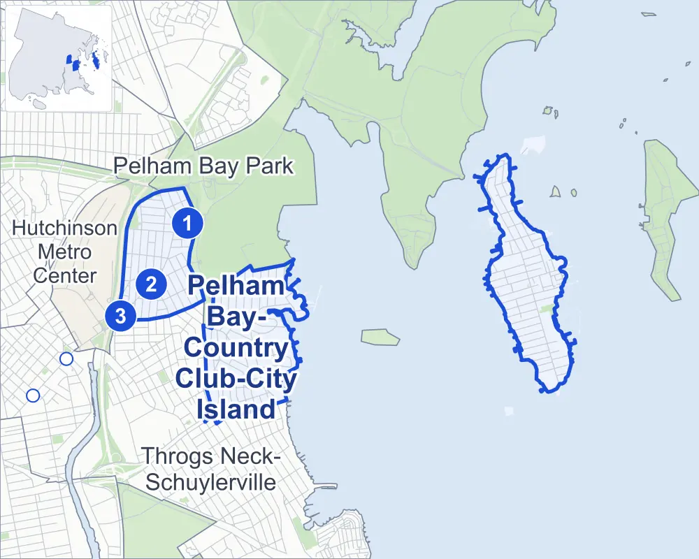
- Pelham Bay-Country Club-City Island
- A neighboring area
- Park
- A station in the list
- Another station
Neighborhood areas and streets: NYC Department of City Planning. Parks: NYC Parks. Stations: MTA.
Neighboring areas
- Throgs Neck-Schuylerville southwest
- Pelham Bay Park west
- Hutchinson Metro Center west
Subway stations
- Pelham Bay Park lines 6 accessible
- Buhre Av lines 6
- Middletown Rd lines 6
Getting around
Three subway stations and buses on 11 routes stop in or at the edge of Pelham Bay-Country Club-City Island.
- 3 subway stations
- 1 of them listed by the MTA as fully accessible
- 9 local bus routes
- 2 express bus routes
Local bus routes
- Bx5
- Bx8
- Bx12
- Bx12-SBS
- Bx23
- Bx24
- Bx29
- Q50
- T103
Express bus routes
- BxM8
- BxM9
Safety record
Between 2021 and 2025, its corners averaged fewer police-reported crashes than the average Bronx corner.
- 490 police-reported crashes at its corners
- 2.0 a corner, on average
- 8.0 the average Bronx corner
- 100 corners with a clean record
Signal or safety changes on City record, at 13 of its corners
- Leading pedestrian intervals
- 7
- Accessible pedestrian signals
- 6
- Barnes Dance all-way crossings
- 2
- Safety Improvement Projects
- 1
Camera tickets
In 2025 its corners had more school-zone speed camera tickets than red-light or bus-lane tickets.
- 0 red-light camera tickets
- 40,744 school-zone speed camera tickets at six corners
- 0 bus-lane camera tickets
- Most speed tickets
- Macdonough Place & Griswold Avenue, 23,590
People and homes
The 2020 Census counted 29,462 residents in Pelham Bay-Country Club-City Island, about 23,200 per square mile.
- 12,920 homes, 2020 Census
- 643 homes added since April 2010, net, by City Planning's count
Half of its 4,563 residential lots hold buildings from 1940 or earlier, and 50% of them date from before 1940, by the City's tax lot records.
Parks and landmarks
- Parkland
- 12 acres of NYC Parks property
- The largest pieces
- Colucci Playground (4 acres), Ambrosini Field (3.6 acres) and Palmer Inlet (2 acres)
- Designated landmark
- The City Island Nautical Museum
Streets and trees
- Trees
- 3,714 in NYC Parks' records, most often London planetree, Callery pear and thornless honeylocust
- Street with the most corners
- City Island Avenue, with 23 of the area's 251
- Height above sea level
- From 7 feet at Hunter Avenue & Ditmars Street to 54 feet at Plymouth Avenue & Daniel Street
- Honorary street names
- 20 at its corners, enacted by local law
Schools and libraries
The City lists nine schools and one library in Pelham Bay-Country Club-City Island.
- Public schools
- 4
- Charter and private schools
- 5
- Library
- City Island Library
Public art
The City's public art inventory lists one work in Pelham Bay-Country Club-City Island: City Island World War Memorial.
- 1 work of public art
Public safety
How complaints are countedIn 2025 the NYPD recorded 398 major felonies at places in Pelham Bay-Country Club-City Island.
Recorded by the NYPD at places in Pelham Bay-Country Club-City Island
- 295 major felonies in 2024
- 779 other felonies, misdemeanors and violations in 2025
In 2025, on the streets along the edge of Pelham Bay-Country Club-City Island, the NYPD recorded another 84 major felonies. Counting the streets along its edge, in 2025 the NYPD recorded 16.4 major felonies for every thousand residents the 2020 Census counted in Pelham Bay-Country Club-City Island.
- Police precinct
- 45th
From January to June 2026 the NYPD recorded 120 major felonies at places in Pelham Bay-Country Club-City Island, against 176 in the same months of 2025.
Sources: the NYPD's Complaint Data Historic, updated April 28, 2026, and Complaint Data Current (Year To Date), updated July 27, 2026, on NYC Open Data. Figures to June 30, 2026.
Street corners
- Ampere Avenue & Bay Shore Avenue
- Ampere Avenue & Bay View Avenue
- Ampere Avenue & Dwight Place
- Ampere Avenue & Kennellworth Place
- Ampere Avenue & Library Avenue
- Ampere Avenue & Ohm Avenue
- Ampere Avenue & Outlook Avenue
- Ampere Avenue & Research Avenue
- Ampere Avenue & Robertson Place
- Arnow Place & Schuyler Place
- Baisley Avenue & Fairfax Avenue
- Baisley Avenue & Throgmorton Avenue
- Bay Street & William Avenue
- Bay View Avenue & Watt Avenue
- Bruckner Boulevard & Arnow Place
- Bruckner Boulevard & Bruckner Expressway
- Bruckner Boulevard & Bruckner Expressway (Exit 7B)
- Bruckner Boulevard & Buhre Avenue
- Bruckner Boulevard & Country Club Road
- Bruckner Boulevard & La Salle Avenue
- Bruckner Boulevard & Macdonough Place
- Bruckner Boulevard & Middletown Road
- Bruckner Boulevard & Roberts Avenue
- Bruckner Boulevard & Sands Place
- Bruckner Boulevard & Throgs Neck Expressway
- Bruckner Boulevard & Waterbury Avenue
- Bruckner Boulevard & Westchester Avenue at Westchester Avenue Pedestrian Overpass
- Bruckner Boulevard & Wilkinson Avenue
- Bruckner Expressway & Country Club Road
- Bruckner Expressway & Throgs Neck Expressway
- Bruckner Expressway & Waterbury-Baisley Avenue Pedestrian Overpass
- Buhre Avenue & Jarvis Avenue
- Buhre Avenue & Mahan Avenue
- Buhre Avenue & Parkview Avenue
- Campbell Drive & Agar Place
- Campbell Drive & Polo Place
- Caroll Street & Deep Water Way
- Caroll Street & William Avenue
- Centre Street & William Avenue
- City Island Avenue & Bay Street
- City Island Avenue & Beach Street
- City Island Avenue & Belden Street
- City Island Avenue & Bowne Street
- City Island Avenue & Buckley Street
- City Island Avenue & Caroll Street
- City Island Avenue & Centre Street
- City Island Avenue & Cross Street
- City Island Avenue & Ditmars Street
- City Island Avenue & Earley Street
- City Island Avenue & Fordham Street
- City Island Avenue & Hawkins Street
- City Island Avenue & Horton Street
- City Island Avenue & Marine Street
- City Island Avenue & Pell Place
- City Island Avenue & Pilot Street
- City Island Avenue & Reville Street
- City Island Avenue & Reynolds Street
- City Island Avenue & Rochelle Street
- City Island Avenue & Schofield Street
- City Island Avenue & Tier Street
- City Island Avenue & Winters Street
- City Island Bridge & City Island Avenue
- Clarence Avenue & Fairmount Avenue
- Country Club Road & Campbell Drive
- Country Club Road & Kearney Avenue
- Country Club Road & Kennellworth Place
- Country Club Road & Lohengrin Place
- Country Club Road & Macdonough Place
- Country Club Road & Polo Place
- Country Club Road & Reed Place
- Country Club Road & Robertson Place
- Country Club Road & Stadium Avenue
- Crosby Avenue & Daniel Street
- Crosby Avenue & Roberts Avenue
- Dean Avenue & Fairmount Avenue
- Deep Water Way & Leeward Lane
- Deep Water Way & Windward Lane
- East 194th Street & Continental Avenue
- East 196th Street & Burr Avenue
- East 196th Street & Colonial Avenue
- East 196th Street & St Paul Avenue
- East 197th Street & Continental Avenue
- Edison Avenue & Buhre Avenue
- Edison Avenue & Roberts Avenue
- Edison Avenue & Santo Donato Place
- Edison Avenue & St Theresa Avenue
- Edison Avenue & Wilkinson Avenue
- Ellsworth Avenue & Baisley Avenue
- Ellsworth Avenue & Fairmount Avenue
- Ellsworth Avenue & Waterbury Avenue
- Fairfax Avenue & Fairmount Avenue
- Fordham Street & Brown Lane
- Fordham Street & Fordham Place
- Fordham Street & William Avenue
- Griswold Avenue & Bay View Avenue
- Griswold Avenue & Kennellworth Place
- Griswold Avenue & Library Avenue
- Griswold Avenue & Ohm Avenue
- Griswold Avenue & Outlook Avenue
- Griswold Avenue & Radio Drive
- Griswold Avenue & Research Avenue
- Griswold Avenue & Robertson Place
- Hawkins Street & Fordham Place
- Hawkins Street & Paulis Place
- Hawkins Street & William Avenue
- High Island Bridge & High Island Path
- Hobart Avenue & Buhre Avenue
- Hobart Avenue & East 194th Street
- Hobart Avenue & East 195th Street
- Hobart Avenue & East 196th Street
- Hobart Avenue & Roberts Avenue
- Hobart Avenue & St Theresa Avenue
- Hobart Avenue & Wilkinson Avenue
- Hollywood Avenue & Middletown Road
- Hunter Avenue & Bowne Street
- Hunter Avenue & Ditmars Street
- Hutchinson River Parkway East & East 197th Street
- Hutchinson River Parkway East & Hutchinson River Parkway
- Hutchinson River Parkway East & Libby Place
- Island Point & Fordham Place
- Kearney Avenue & Connell Place
- Kennellworth Place & Randolph Place
- King Avenue & Beach Street
- King Avenue & Bowne Street
- King Avenue & Ditmars Street
- King Avenue & Fordham Street
- King Avenue & Kilroe Street
- King Avenue & Kirby Street
- King Avenue & Reville Street
- King Avenue & Sutherland Street
- King Avenue & Terrace Street
- King Avenue & Tier Street
- Layton Avenue & Throgmorton Avenue
- Library Avenue & Watt Avenue
- Lohengrin Place & Valhalla Drive
- Macdonough Place & Bruckner Expressway
- Macdonough Place & Connell Place
- Macdonough Place & Dwight Place
- Macdonough Place & Griswold Avenue
- Macdonough Place & Rawlins Avenue
- Mahan Avenue & Willow Lane
- Mayflower Avenue & Buhre Avenue
- Mayflower Avenue & East 194th Street
- Mayflower Avenue & East 195th Street
- Mayflower Avenue & East 196th Street
- Mayflower Avenue & St Theresa Avenue
- Mayflower Avenue & Wilkinson Avenue
- Middletown Road & Ampere Avenue
- Middletown Road & Dwight Place
- Middletown Road & Hobart Avenue
- Middletown Road & Kennellworth Place
- Middletown Road & Macdonough Place
- Middletown Road & Mahan Avenue
- Middletown Road & Ohm Avenue
- Middletown Road & Parkview Avenue
- Middletown Road & Pilgrim Avenue
- Middletown Road & Robertson Place
- Middletown Road & Stadium Avenue
- Minnieford Avenue & Beach Street
- Minnieford Avenue & Bowne Street
- Minnieford Avenue & Bridge Street
- Minnieford Avenue & Caroll Street
- Minnieford Avenue & Cross Street
- Minnieford Avenue & Ditmars Street
- Minnieford Avenue & Fordham Street
- Minnieford Avenue & Hawkins Street
- Minnieford Avenue & Kilroe Street
- Minnieford Avenue & Sutherland Street
- Mulford Avenue & Buhre Avenue
- Mulford Avenue & Laurie Avenue
- Mulford Avenue & Libby Place
- Mulford Avenue & St Theresa Avenue
- Mulford Avenue & Wilkinson Avenue
- Outlook Avenue & Bay Shore Avenue
- Parkview Avenue & Willow Lane
- Parsifal Place & Ellis Place
- Parsifal Place & Lohengrin Place
- Pelham Parkway South & Colonial Avenue
- Pelham Parkway South & Hutchinson River Parkway East
- Pelham Parkway South & Pelham Parkway
- Pelham Parkway South & St Paul Avenue
- Pilgrim Avenue & Buhre Avenue
- Pilgrim Avenue & Santo Donato Place
- Pilgrim Avenue & St Theresa Avenue
- Pilgrim Avenue & Wilkinson Avenue
- Plymouth Avenue & Daniel Street
- Rawlins Avenue & Ellis Place
- Rawlins Avenue & Lohengrin Place
- Rawlins Avenue & Teddy Place
- Research Avenue & Watt Avenue
- Roberts Avenue & Jarvis Avenue
- Roberts Avenue & Mahan Avenue
- Roberts Avenue & Mulford Avenue
- Roberts Avenue & Parkview Avenue
- Roberts Avenue & Pilgrim Avenue
- Roberts Avenue & Plymouth Avenue
- Sands Place & Schuyler Place
- Schofield Street & Landing Way
- Schofield Street & William Avenue
- Spencer Drive & Griswold Avenue
- Spencer Drive & Kennellworth Place
- Spencer Drive & Lucerne Street
- Spencer Drive & Ohm Avenue
- Spencer Drive & Reed Place
- Spencer Drive & Robertson Place
- Stadium Avenue & Agar Place
- Stadium Avenue & Ampere Avenue
- Stadium Avenue & Campbell Drive
- Stadium Avenue & Fairmount Avenue
- Stadium Avenue & Griswold Avenue
- Stadium Avenue & Layton Avenue
- Stadium Avenue & Lucerne Street
- Stadium Avenue & Parsifal Place
- Stadium Avenue & Polo Place
- Stadium Avenue & Randolph Place
- Stadium Avenue & Rawlins Avenue
- Stadium Avenue & Spencer Drive
- Stadium Avenue & Watt Avenue
- Throgmorton Avenue & Fairmount Avenue
- Throgs Neck Expressway & Layton Avenue
- Tier Street & William Avenue
- Valhalla Drive & Siegfried Place
- Vincent Avenue & Baisley Avenue
- Vincent Avenue & Fairmount Avenue
- Vincent Avenue & Layton Avenue
- Waterbury Avenue & Baisley Avenue
- Waterbury Avenue & Fairfax Avenue
- Waterbury Avenue & Kearney Avenue
- Waterbury Avenue & Stadium Avenue
- Waterbury Avenue & Throgmorton Avenue
- Waterbury Avenue & Vincent Avenue
- Waterbury Avenue & Wilcox Avenue
- Westchester Avenue & Arnow Place
- Westchester Avenue & Burr Avenue
- Westchester Avenue & Colonial Avenue
- Westchester Avenue & Continental Avenue
- Westchester Avenue & Crosby Avenue
- Westchester Avenue & Edison Avenue
- Westchester Avenue & Hobart Avenue
- Westchester Avenue & Hutchinson River Parkway East
- Westchester Avenue & Mahan Avenue
- Westchester Avenue & Mayflower Avenue
- Westchester Avenue & Mulford Avenue
- Westchester Avenue & Pilgrim Avenue
- Westchester Avenue & Roberts Avenue
- Westchester Avenue & Sands Place
- Westchester Avenue & St Paul Avenue
- Westchester Avenue & Wilkinson Avenue
- Wilcox Avenue & Fairmount Avenue
- Wilcox Avenue & Layton Avenue
- Wilkinson Avenue & Continental Avenue
How the figures above are measured: Methodology.