Westchester Square
Neighborhood · Bronx
Westchester Square lies in the eastern Bronx, with Westchester Creek along its eastern edge.
- 0.55 square miles
- 17,376 residents, 2020 Census
- 137 street corners
- 3 subway stations
- 11 bus routes
It grew from the colonial village of Westchester, also called Oostdorp, or East Town, which English settlers founded about 1654 on land bought by Thomas Pell; the village was the seat of the Town of Westchester until the town joined New York City in 1895. Two city landmarks stand near the square, St. Peter's Church, Chapel and Cemetery and the Huntington Free Library and Reading Room, and the Westchester Square station on the Pelham Line has served the area since 1920.
Sources: Westchester Square, Bronx (Wikipedia); List of New York City Designated Landmarks in the Bronx (Wikipedia); About BXCB10 (Bronx Community Board 10).
Westchester Square borders five areas, and Zerega Avenue holds more of its corners than any other street, 26 of 137.
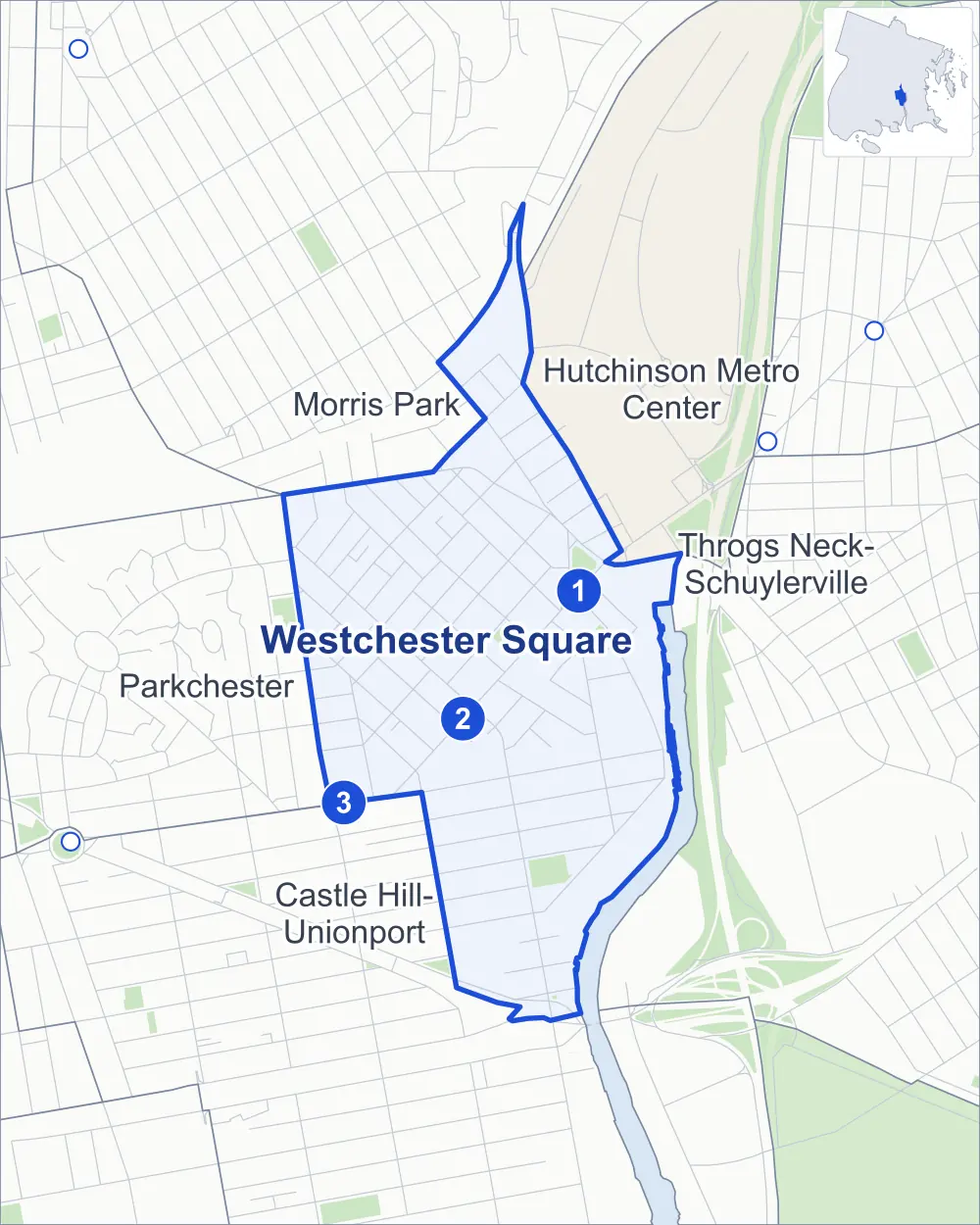
- Westchester Square
- A neighboring area
- Park
- A station in the list
- Another station
Neighborhood areas and streets: NYC Department of City Planning. Parks: NYC Parks. Stations: MTA.
Neighboring areas
- Morris Park north
- Hutchinson Metro Center north
- Throgs Neck-Schuylerville northeast
- Castle Hill-Unionport south
- Parkchester west
Subway stations
- Westchester Sq-E Tremont Av lines 6 accessible
- Zerega Av lines 6
- Castle Hill Av lines 6
Getting around
Three subway stations and buses on 11 routes stop in or at the edge of Westchester Square.
- 3 subway stations
- 1 of them listed by the MTA as fully accessible
- 11 local bus routes
Local bus routes
- Bx4
- Bx4A
- Bx8
- Bx21
- Bx22
- Bx24
- Bx31
- Bx40
- Bx42
- Q44-SBS
- T103
Safety record
Between 2021 and 2025, its corners averaged fewer police-reported crashes than the average Bronx corner.
- 596 police-reported crashes at its corners
- 4.4 a corner, on average
- 8.0 the average Bronx corner
- 17 corners with a clean record
Signal or safety changes on City record, at 15 of its corners
- Leading pedestrian intervals
- 9
- Accessible pedestrian signals
- 7
- Turn calming
- 3
- Barnes Dance all-way crossings
- 2
- Safety Improvement Projects
- 1
Camera tickets
In 2025 its corners had more school-zone speed camera tickets than red-light or bus-lane tickets.
- 0 red-light camera tickets
- 8,120 school-zone speed camera tickets at six corners
- 0 bus-lane camera tickets
- Most speed tickets
- Gleason Avenue & Commerce Avenue, 4,716
People and homes
The 2020 Census counted 17,376 residents in Westchester Square, about 31,600 per square mile.
- 5,704 homes, 2020 Census
- 503 homes added since April 2010, net, by City Planning's count
Half of its 1,378 residential lots hold buildings from 1925 or earlier, and 73% of them date from before 1940, by the City's tax lot records.
NYCHA development
One NYCHA development, which NYCHA names by a building's address, lies wholly or partly within Westchester Square.
Parks and landmarks
- Parkland
- 4.3 acres of NYC Parks property
- The largest pieces
- Castle Hill Little League Field (2.2 acres), Owen F. Dolen Park (1.4 acres) and the Pearly Gates (0.7 acre)
- Designated landmarks
- The Van Schaick Free Reading Room and Saint Peter's Church
Streets and trees
- Trees
- 2,097 in NYC Parks' records, most often thornless honeylocust, Japanese zelkova and Japanese flowering cherry
- Street with the most corners
- Zerega Avenue, with 26 of the area's 137
- Height above sea level
- From 8 feet at Ellis Avenue & Commerce Avenue to 53 feet at Yates Avenue & Sacket Avenue
- Honorary street names
- 6 at its corners, enacted by local law
Schools and libraries
The City lists four schools and one library in Westchester Square.
- Public schools
- 4
- Library
- Westchester Square Library
Public art
The City's public art inventory lists two works in Westchester Square: Westchester Square Memorial (1925) and Seat (1987).
- 2 works of public art
Public safety
How complaints are countedIn 2025 the NYPD recorded 333 major felonies at places in Westchester Square.
Recorded by the NYPD at places in Westchester Square
- 321 major felonies in 2024
- 697 other felonies, misdemeanors and violations in 2025
In 2025, on the streets along the edge of Westchester Square, the NYPD recorded another 106 major felonies. Counting the streets along its edge, in 2025 the NYPD recorded 25.3 major felonies for every thousand residents the 2020 Census counted in Westchester Square.
- Police precincts
- 45th (most of the area), 43rd, 49th
From January to June 2026 the NYPD recorded 119 major felonies at places in Westchester Square, against 163 in the same months of 2025.
Sources: the NYPD's Complaint Data Historic, updated April 28, 2026, and Complaint Data Current (Year To Date), updated July 27, 2026, on NYC Open Data. Figures to June 30, 2026.
Street corners
- Blondell Avenue & Chesbrough Avenue
- Blondell Avenue & Ponton Avenue
- Bruckner Boulevard & Cross Bronx Expressway at Bruckner Expressway
- Bruckner Boulevard & East 177th Street
- Bruckner Boulevard & Hutchinson River Parkway at Bruckner Expressway
- Butler Place & Herschell Street
- Butler Place & Rowe Street
- Castle Hill Avenue & Lyon Avenue
- Castle Hill Avenue & Metropolitan Avenue
- Castle Hill Avenue & Parker Street
- Castle Hill Avenue & Westchester Avenue
- Castle Hill Avenue & Zerega Avenue
- Commerce Avenue & Butler Place
- Commerce Avenue & Halsey Street
- Commerce Avenue & Seabury Avenue
- Cross Bronx Expressway & Bruckner Expressway
- Dorsey Street & Hubbell Street
- East 177th Street & Chatterton Avenue
- East Tremont Avenue & Benson Street
- East Tremont Avenue & Fink Avenue
- East Tremont Avenue & Frisby Avenue
- East Tremont Avenue & Lane Avenue
- East Tremont Avenue & Lyvere Street
- East Tremont Avenue & Maclay Avenue
- East Tremont Avenue & Montgomery Place
- East Tremont Avenue & Paulding Avenue
- East Tremont Avenue & Ponton Avenue
- East Tremont Avenue & Seddon Street
- East Tremont Avenue & Silver Street
- East Tremont Avenue & St Raymond Avenue
- East Tremont Avenue & Westchester Avenue
- East Tremont Avenue & Williamsbridge Road
- Eastchester Road & Bassett Avenue
- Eastchester Road & Jarrett Place
- Eastchester Road & Waters Place
- Eastchester Road & Williamsbridge Road
- Ellis Avenue & Commerce Avenue
- Ellis Avenue & Seabury Avenue
- Frisby Avenue & Benson Street
- Frisby Avenue & Overing Street
- Frisby Avenue & Rowland Street
- Gleason Avenue & Commerce Avenue
- Gleason Avenue & Havemeyer Avenue
- Glebe Avenue & Glover Street
- Glebe Avenue & Lyon Avenue
- Glebe Avenue & Manning Street
- Glebe Avenue & Overing Street
- Glebe Avenue & Parker Street
- Glebe Avenue & Rowland Street
- Glebe Avenue & St Peters Avenue
- Glebe Avenue & Starling Avenue
- Glover Street & Lyon Avenue
- Glover Street & Stearns Street
- Halsey Street & Kinnear Place
- Havemeyer Avenue & Haviland Avenue
- Hering Avenue & Sacket Avenue
- Herschell Street & Halsey Street
- Lane Avenue & Benson Street
- Lyon Avenue & Doris Street
- Maclay Avenue & Benson Street
- Maclay Avenue & Hubbell Street
- Maclay Avenue & Montgomery Place
- Maclay Avenue & Overing Street
- Maclay Avenue & Seddon Street
- Newbold Avenue & Commerce Avenue
- Newbold Avenue & Seabury Avenue
- Parker Street & Lyon Avenue
- Parker Street & Maclay Avenue
- Parker Street & Stearns Street
- Poplar Street & Jarrett Place
- Sacket Avenue & Albert Einstein College Driveway
- Seabury Avenue & Butler Place
- Seabury Avenue & Halsey Street
- Seabury Avenue & Herschell Street
- Seabury Avenue & Rowe Street
- Seddon Street & Buck Street
- Seddon Street & Dorsey Street
- Seddon Street & Fuller Street
- Silver Street & Roselle Street
- St Peters Avenue & Frisby Avenue
- St Peters Avenue & Maclay Avenue
- St Raymond Avenue & Benson Street
- St Raymond Avenue & Blondell Avenue
- St Raymond Avenue & Glover Street
- St Raymond Avenue & Marvin Place
- St Raymond Avenue & Overing Street
- St Raymond Avenue & Parker Street
- St Raymond Avenue & Rowland Street
- St Raymond Avenue & Seddon Street
- St Raymond Avenue & St Peters Avenue
- Tratman Avenue & Benson Street
- Tratman Avenue & Overing Street
- Tratman Avenue & Rowland Street
- Tratman Avenue & St Peters Avenue
- Waterbury Avenue & Commerce Avenue
- Waterbury Avenue & Havemeyer Avenue
- Waterbury Avenue & Seabury Avenue
- Westchester Avenue & Commerce Avenue
- Westchester Avenue & Ferris Place
- Westchester Avenue & Glebe Avenue
- Westchester Avenue & Glover Street
- Westchester Avenue & Havemeyer Avenue
- Westchester Avenue & Herschell Street
- Westchester Avenue & Lane Avenue
- Westchester Avenue & Parker Street
- Westchester Avenue & Rowland Street
- Westchester Avenue & Seabury Avenue
- Westchester Avenue & St Peters Avenue
- Westchester Avenue & Waterbury Avenue
- Westchester Avenue & Zerega Avenue
- Williamsbridge Road & Chesbrough Avenue
- Williamsbridge Road & Halperin Avenue
- Williamsbridge Road & St Raymond Avenue
- Yates Avenue & Sacket Avenue
- Zerega Avenue & Blackrock Avenue
- Zerega Avenue & Buck Street
- Zerega Avenue & Butler Place
- Zerega Avenue & Chatterton Avenue
- Zerega Avenue & Cross Bronx Expressway
- Zerega Avenue & Dorsey Street
- Zerega Avenue & Ellis Avenue
- Zerega Avenue & Frisby Avenue
- Zerega Avenue & Fuller Street
- Zerega Avenue & Gleason Avenue
- Zerega Avenue & Glebe Avenue
- Zerega Avenue & Halsey Street
- Zerega Avenue & Haviland Avenue
- Zerega Avenue & Hutchinson River Parkway
- Zerega Avenue & Lyon Avenue
- Zerega Avenue & Lyvere Street
- Zerega Avenue & Maclay Avenue
- Zerega Avenue & Newbold Avenue
- Zerega Avenue & Powell Avenue
- Zerega Avenue & St Raymond Avenue
- Zerega Avenue & Tratman Avenue
- Zerega Avenue & Waterbury Avenue
- Zerega Avenue & Watson Avenue
How the figures above are measured: Methodology.