Parkchester
Neighborhood · Bronx
Laid out as a planned community, Parkchester fills the Bronx blocks framed by East Tremont Avenue, Castle Hill Avenue, Westchester Avenue and White Plains Road.
- 0.33 square miles
- 33,602 residents, 2020 Census
- 47 street corners
- 2 subway stations
- 11 bus routes
The Metropolitan Life Insurance Company built it between 1939 and 1942 on former farmland of the New York Catholic Protectory, raising 51 groups of brick buildings planned for 12,000 families. Its name blends those of two neighboring areas, Park Versailles and Westchester Heights. About 500 terra cotta statuettes and 600 plaques decorate its buildings, Raymond Granville Barger's Fantasia fountain stands in the Aileen B. Ryan Oval, and the 6 train stops at Parkchester station on Westchester Avenue.
Sources: Parkchester, Bronx (Wikipedia); About BXCB9 (Bronx Community Board 9).
Parkchester borders four areas, and Unionport Road holds more of its corners than any other street, eight of 47.
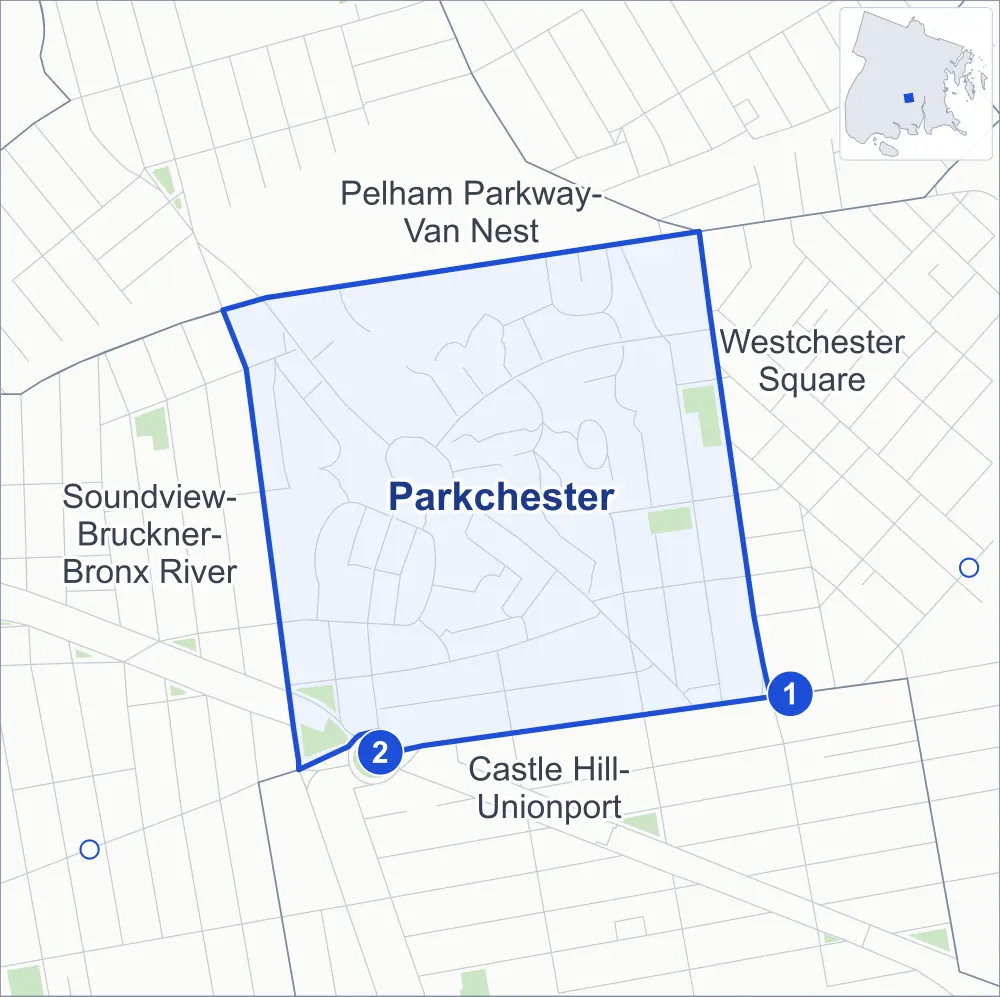
- Parkchester
- A neighboring area
- Park
- A station in the list
- Another station
Neighborhood areas and streets: NYC Department of City Planning. Parks: NYC Parks. Stations: MTA.
Neighboring areas
Subway stations
- Castle Hill Av lines 6
- Parkchester lines 6 accessible
Getting around
Two subway stations and buses on 11 routes stop in or at the edge of Parkchester.
- 2 subway stations
- 1 of them listed by the MTA as fully accessible
- 10 local bus routes
- 1 express bus route
Local bus routes
- Bx4
- Bx4A
- Bx11
- Bx22
- Bx36
- Bx39
- Bx40
- Bx42
- Q44-SBS
- T103
Express bus route
- BxM6
Safety record
Between 2021 and 2025, its corners averaged more police-reported crashes than the average Bronx corner.
- 464 police-reported crashes at its corners
- 9.9 a corner, on average
- 8.0 the average Bronx corner
Signal or safety changes on City record, at 19 of its corners
- Accessible pedestrian signals
- 15
- Leading pedestrian intervals
- 8
- Turn calming
- 2
- Enhanced crossings
- 2
Camera tickets
In 2025 its corners had more school-zone speed camera tickets than red-light or bus-lane tickets.
- 0 red-light camera tickets
- 4,192 school-zone speed camera tickets at four corners
- 0 bus-lane camera tickets
- Most speed tickets
- Unionport Road & Guerlain Street, 2,167
People and homes
The 2020 Census counted 33,602 residents in Parkchester, about 101,800 per square mile.
- 14,007 homes, 2020 Census
- 466 homes added since April 2010, net, by City Planning's count
Half of its 277 residential lots hold buildings from 1926 or earlier, and 79% of them date from before 1940, by the City's tax lot records.
Parks
- Parkland
- 3.7 acres of NYC Parks property
- The largest pieces
- Castle Hill Playground (1.4 acres), Virginia Park (1 acre) and Caserta Playground (0.9 acre)
Streets and trees
- Trees
- 1,116 in NYC Parks' records, most often thornless honeylocust, London planetree and pin oak
- Street with the most corners
- Unionport Road, with eight of the area's 47
- Height above sea level
- From 21 feet at White Plains Road & Wood Avenue to 66 feet at White Plains Road & East Tremont Avenue
- Honorary street names
- 6 at its corners, enacted by local law
Schools and libraries
The City lists nine schools and one library in Parkchester.
- Public schools
- 3
- Charter and private schools
- 6
- Library
- Parkchester Library
Public safety
How complaints are countedIn 2025 the NYPD recorded 274 major felonies at places in Parkchester.
Recorded by the NYPD at places in Parkchester
- 289 major felonies in 2024
- 746 other felonies, misdemeanors and violations in 2025
In 2025, on the streets along the edge of Parkchester, the NYPD recorded another 172 major felonies. Counting the streets along its edge, in 2025 the NYPD recorded 13.3 major felonies for every thousand residents the 2020 Census counted in Parkchester.
- Police precinct
- 43rd
From January to June 2026 the NYPD recorded 109 major felonies at places in Parkchester, against 136 in the same months of 2025.
Sources: the NYPD's Complaint Data Historic, updated April 28, 2026, and Complaint Data Current (Year To Date), updated July 27, 2026, on NYC Open Data. Figures to June 30, 2026.
Street corners
- Castle Hill Avenue & Glover Street
- Castle Hill Avenue & Manning Street
- Castle Hill Avenue & St Raymond Avenue
- Castle Hill Avenue & Starling Avenue
- Cross Bronx Expressway & White Plains Road
- East 177th Street & Virginia Avenue
- East Avenue & Yankee Mall
- East Tremont Avenue & Bronxdale Avenue
- East Tremont Avenue & Dogwood Drive
- Guerlain Street & Archer Road
- Metropolitan Avenue & Hugh J Grant Circle
- Metropolitan Avenue & McGraw Avenue
- Metropolitan Avenue & Metropolitan Oval (north-east)
- Metropolitan Avenue & Metropolitan Oval (south-west)
- Metropolitan Avenue & Wood Avenue
- Metropolitan Avenue & Yankee Mall
- Odell Street & Starling Avenue
- Olmstead Avenue & Benedict Avenue
- Olmstead Avenue & St Raymond Avenue
- Olmstead Avenue & Starling Avenue
- Olmstead Avenue & Unionport Road
- Parkchester Road & East Avenue (north)
- Parkchester Road & East Avenue (south)
- Pugsley Avenue & Benedict Avenue
- Pugsley Avenue & McGraw Avenue
- Purdy Street & Metropolitan Avenue
- Purdy Street & Parker Street
- Purdy Street & Starling Avenue
- St Raymond Avenue & Odell Street
- St Raymond Avenue & Purdy Street
- Unionport Road & Benedict Avenue
- Unionport Road & Guerlain Street
- Unionport Road & McGraw Avenue
- Unionport Road & Metropolitan Oval (north-west)
- Unionport Road & Metropolitan Oval (south-east)
- Unionport Road & Odell Street
- Unionport Road & Starling Avenue
- Virginia Avenue & McGraw Avenue
- Virginia Avenue & Wood Avenue
- Westchester Avenue & East 177th Street
- Westchester Avenue & Olmstead Avenue
- Westchester Avenue & Pugsley Avenue
- White Plains Road & East 177th Street
- White Plains Road & East Tremont Avenue
- White Plains Road & Wood Avenue
- Wood Road & West Avenue
- Wood Road & Wood Avenue
How the figures above are measured: Methodology.