Morris Park
Neighborhood · Bronx
Morris Park lies in the Bronx between White Plains Road and Eastchester Road, with Pelham Parkway, a late-19th-century link between Bronx Park and Pelham Bay Park, along its northern side.
- 1.00 square mile
- 25,077 residents, 2020 Census
- 179 street corners
- 1 subway station
- 11 bus routes
It is named for John Albert Morris, who opened the Morris Park Racecourse here in 1889; the Belmont Stakes was run on its track, and the grounds hosted the first public air show. After 1910 the land was divided into building lots, and the neighborhood grew into a largely Italian-American community, with the Albert Einstein College of Medicine and Jacobi Medical Center along its eastern edge.
Sources: Morris Park, Bronx (Wikipedia); Pelham Parkway (NYC Parks).
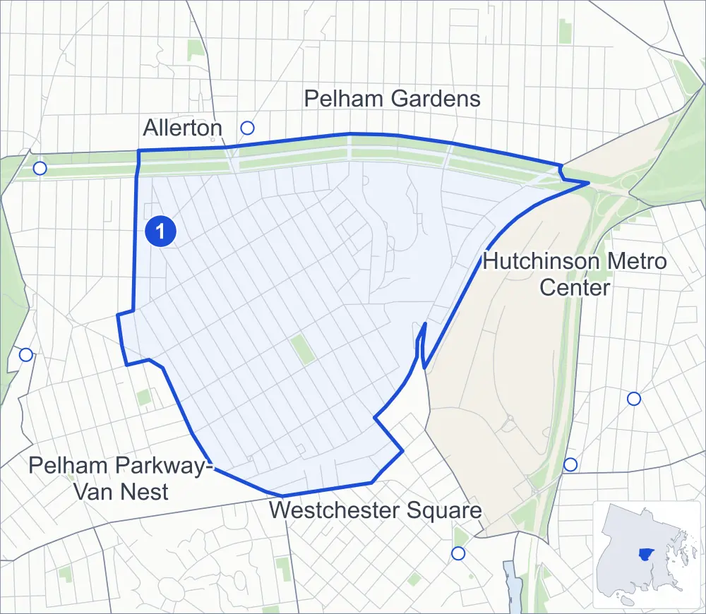
Morris Park borders five areas, and Morris Park Avenue and Rhinelander Avenue hold more of its corners than any other street, 18 each of 179.
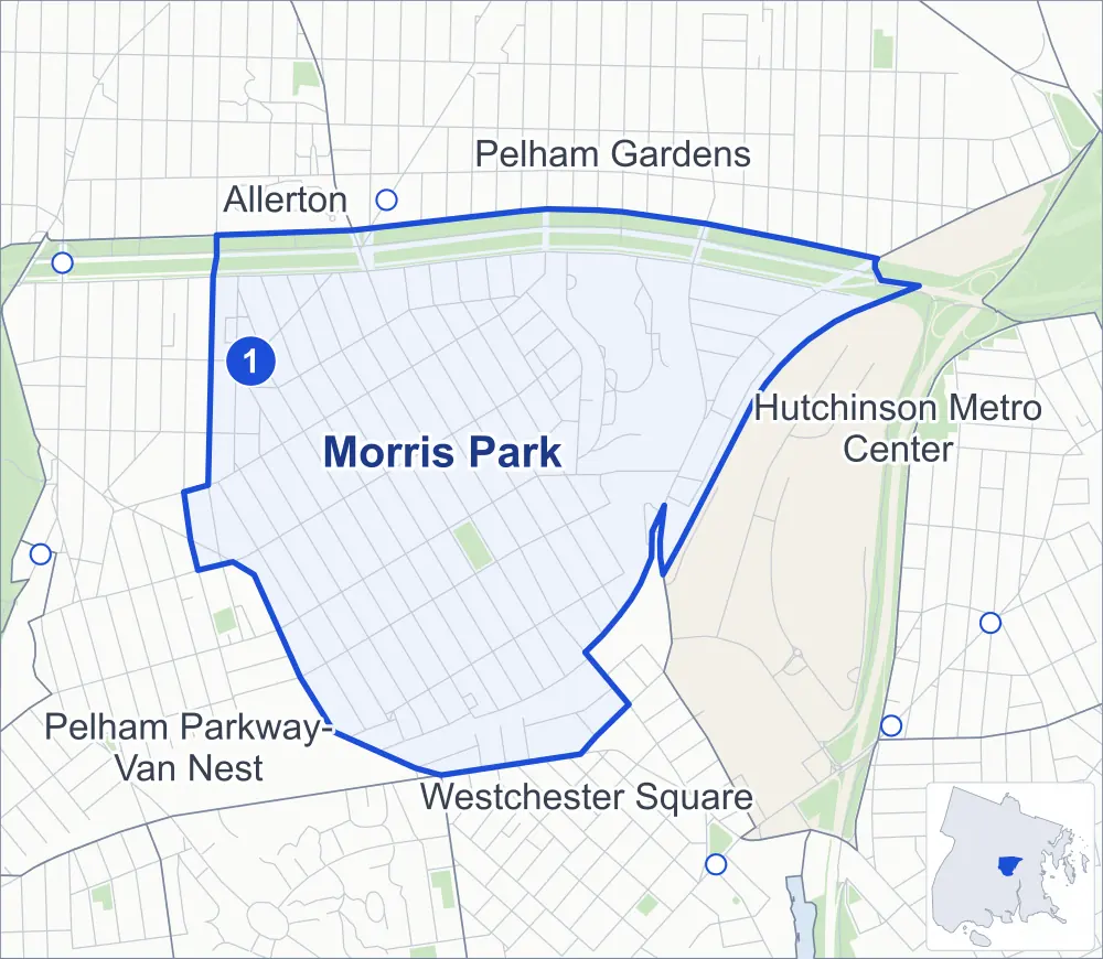
- Morris Park
- A neighboring area
- Park
- A station in the list
- Another station
Neighborhood areas and streets: NYC Department of City Planning. Parks: NYC Parks. Stations: MTA.
Neighboring areas
- Pelham Gardens northeast
- Hutchinson Metro Center east
- Westchester Square southeast
- Pelham Parkway-Van Nest west
- Allerton northwest
Subway stations
- Morris Park lines 5
Getting around
One subway station and buses on 11 routes stop in or at the edge of Morris Park.
- 1 subway station
- 10 local bus routes
- 1 express bus route
Local bus routes
- Bx4A
- Bx8
- Bx12
- Bx12-SBS
- Bx21
- Bx24
- Bx31
- Bx40
- Bx42
- T113
Express bus route
- BxM10
Safety record
Between 2021 and 2025, its corners averaged fewer police-reported crashes than the average Bronx corner.
- 728 police-reported crashes at its corners
- 4.1 a corner, on average
- 8.0 the average Bronx corner
- 39 corners with a clean record
Signal or safety changes on City record, at 30 of its corners
- Leading pedestrian intervals
- 23
- Accessible pedestrian signals
- 17
- Turn calming
- 7
- Barnes Dance all-way crossings
- 3
- Safety Improvement Projects
- 1
Camera tickets
In 2025 its corners had more school-zone speed camera tickets than red-light or bus-lane tickets.
- 0 red-light camera tickets
- 12,544 school-zone speed camera tickets at eight corners
- 0 bus-lane camera tickets
- Most speed tickets
- East Tremont Avenue & Lurting Avenue, 5,790
People and homes
The 2020 Census counted 25,077 residents in Morris Park, about 25,100 per square mile.
- 9,722 homes, 2020 Census
- 222 homes added since April 2010, net, by City Planning's count
Half of its 3,594 residential lots hold buildings from 1940 or earlier, and 49% of them date from before 1940, by the City's tax lot records.
Parks
- Parkland
- 2.2 acres of Loreto Playground, as NYC Parks maps it within Morris Park
Streets and trees
- Trees
- 4,356 in NYC Parks' records, most often London planetree, pin oak and thornless honeylocust
- Street with the most corners
- Morris Park Avenue, with 18 of the area's 179
- Height above sea level
- From 20 feet at Pelham Parkway North & Tiemann Avenue to 108 feet at Pelham Parkway North & Esplanade
- Honorary street names
- 10 at its corners, enacted by local law
Schools and libraries
The City lists 13 schools and one library in Morris Park.
- Public schools
- 4
- Charter and private schools
- 9
- Library
- Morris Park Library
Public safety
How complaints are countedIn 2025 the NYPD recorded 407 major felonies at places in Morris Park.
Recorded by the NYPD at places in Morris Park
- 358 major felonies in 2024
- 969 other felonies, misdemeanors and violations in 2025
In 2025, on the streets along the edge of Morris Park, the NYPD recorded another 72 major felonies. Counting the streets along its edge, in 2025 the NYPD recorded 19.1 major felonies for every thousand residents the 2020 Census counted in Morris Park.
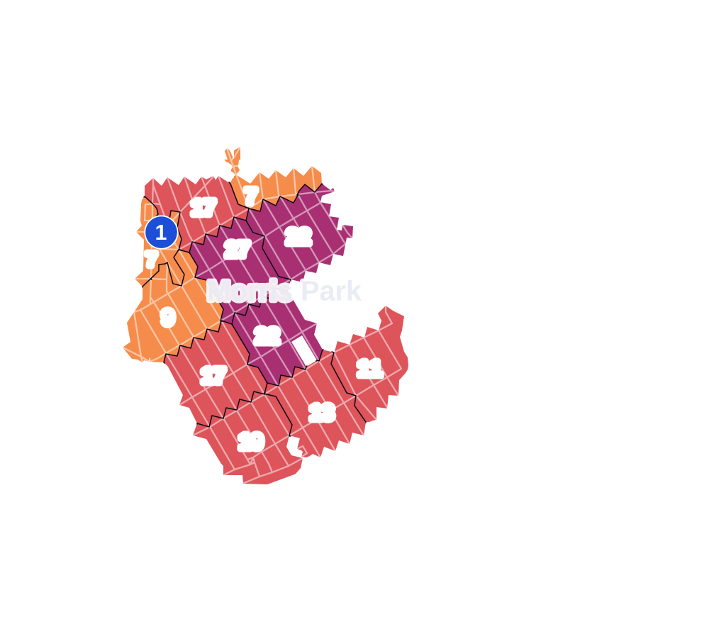
- 5 to 9
- 10 to 19
- 20 to 49
- 50 to 99
- 100 or more
- Not shaded: fewer than 5, held back under the rules in How complaints are counted, parks and public-housing grounds, and land in no patch
- Police precinct
- 49th
From January to June 2026 the NYPD recorded 137 major felonies at places in Morris Park, against 173 in the same months of 2025.
Sources: the NYPD's Complaint Data Historic, updated April 28, 2026, and Complaint Data Current (Year To Date), updated July 27, 2026, on NYC Open Data. Figures to June 30, 2026.
Street corners
- Bassett Avenue & Wilkinson Avenue
- Bogart Avenue & Brady Avenue
- Bogart Avenue & Lydig Avenue
- Bogart Avenue & Neill Avenue
- Bogart Avenue & Sacket Avenue
- Bogart Avenue & Woodmansten Place
- Bronxdale Avenue & Kinsella Street
- Bronxdale Avenue & Muliner Avenue
- Bronxdale Avenue & Poplar Street
- Bronxdale Avenue & Sacket Avenue
- Colden Avenue & Bogart Avenue
- Colden Avenue & Lydig Avenue
- Colden Avenue & Neill Avenue
- Colden Avenue & Pierce Avenue
- Colden Avenue & Radcliff Avenue
- Colden Avenue & Rhinelander Avenue
- Colden Avenue & Sacket Avenue
- Colden Avenue & Van Nest Avenue
- East Tremont Avenue & Hone Avenue
- East Tremont Avenue & Lurting Avenue
- East Tremont Avenue & Overing Street
- East Tremont Avenue & St Peters Avenue
- Eastchester Road & Loomis Street
- Eastchester Road & McDonald Street
- Eastchester Road & Morris Park Avenue
- Eastchester Road & Pelham Parkway
- Eastchester Road & Pelham Parkway South
- Eastchester Road & Rhinelander Avenue
- Eastchester Road & Sacket Avenue
- Eastchester Road & Seminole Street
- Eastchester Road & Stillwell Avenue
- Eastchester Road & Stillwell Avenue at Wilkinson Avenue
- Haight Avenue & Esplanade
- Haight Avenue & Lydig Avenue
- Haight Avenue & Neill Avenue
- Haight Avenue & Pierce Avenue
- Haight Avenue & Sacket Avenue
- Hering Avenue & Lakewood Place
- Hering Avenue & Lydig Avenue
- Hering Avenue & Neill Avenue
- Hering Avenue & Pierce Avenue
- Hering Avenue & Rhinelander Avenue
- Hone Avenue & Esplanade
- Hone Avenue & Lydig Avenue
- Hone Avenue & Morris Park Avenue
- Hone Avenue & Neill Avenue
- Hone Avenue & Pierce Avenue
- Hone Avenue & Rhinelander Avenue
- Hone Avenue & Sacket Avenue
- Hone Avenue & Van Nest Avenue
- Jacobi Medical Center Access Road & Seminole Avenue
- Lurting Avenue & Esplanade
- Lurting Avenue & Lydig Avenue
- Lurting Avenue & Neill Avenue
- Lurting Avenue & Pierce Avenue
- Lurting Avenue & Poplar Street
- Lurting Avenue & Rhinelander Avenue
- Lurting Avenue & Sacket Avenue
- Lurting Avenue & Van Nest Avenue
- Lydig Avenue & Narragansett Avenue
- Lydig Avenue & Neill Avenue
- Lydig Avenue & Van Hoesen Avenue
- Matthews Avenue & Bronxdale Avenue
- Matthews Avenue & Rhinelander Avenue
- Morris Park Avenue & Bassett Avenue
- Morris Park Avenue & Bogart Avenue
- Morris Park Avenue & Bronxdale Avenue
- Morris Park Avenue & Colden Avenue
- Morris Park Avenue & Fowler Avenue
- Morris Park Avenue & Haight Avenue
- Morris Park Avenue & Hering Avenue
- Morris Park Avenue & Lurting Avenue
- Morris Park Avenue & Newport Avenue
- Morris Park Avenue & Radcliff Avenue
- Morris Park Avenue & Seminole Avenue
- Morris Park Avenue & Tenbroeck Avenue
- Morris Park Avenue & Tomlinson Avenue
- Morris Park Avenue & Yates Avenue
- Narragansett Avenue & Choctaw Place
- Narragansett Avenue & Lakewood Place
- Narragansett Avenue & Pawnee Place
- Narragansett Avenue & Pinchot Place
- Neill Avenue & Fowler Avenue
- Neill Avenue & Muliner Avenue
- Neill Avenue & Narragansett Avenue
- Neill Avenue & Seminole Avenue
- Paulding Avenue & Bogart Avenue (north)
- Paulding Avenue & Bogart Avenue (south)
- Paulding Avenue & Lydig Avenue
- Paulding Avenue & Morris Park Avenue
- Paulding Avenue & Neill Avenue
- Paulding Avenue & Pierce Avenue
- Paulding Avenue & Poplar Street
- Paulding Avenue & Rhinelander Avenue
- Paulding Avenue & Sacket Avenue
- Paulding Avenue & Van Nest Avenue
- Pelham Parkway & Hutchinson Parkway
- Pelham Parkway & Seymour Avenue
- Pelham Parkway & Stillwell Avenue
- Pelham Parkway & Williamsbridge Road
- Pelham Parkway North & Bouck Avenue
- Pelham Parkway North & Esplanade
- Pelham Parkway North & Kingsland Avenue
- Pelham Parkway North & Mickle Avenue
- Pelham Parkway North & Pearsall Avenue
- Pelham Parkway North & Seymour Avenue
- Pelham Parkway North & Tenbroeck Avenue
- Pelham Parkway North & Tiemann Avenue
- Pelham Parkway North & Wilson Avenue
- Pelham Parkway South & Bogart Avenue
- Pelham Parkway South & Esplanade
- Pelham Parkway South & Haight Avenue
- Pelham Parkway South & Hering Avenue
- Pelham Parkway South & Hone Avenue
- Pelham Parkway South & Jacobi Medical Center Access Road (east)
- Pelham Parkway South & Jacobi Medical Center Access Road (west)
- Pelham Parkway South & Lurting Avenue
- Pelham Parkway South & Narragansett Avenue
- Pelham Parkway South & Stillwell Avenue
- Pelham Parkway South & Tenbroeck Avenue
- Pelham Parkway South & Tomlinson Avenue
- Pelham Parkway South & Van Hoesen Avenue
- Pelham Parkway South & Williamsbridge Road
- Pelham Parkway South & Wilson Avenue
- Pelham Parkway South & Yates Avenue
- Pierce Avenue & Fowler Avenue
- Poplar Street & Roselle Street
- Radcliff Avenue & Brady Avenue
- Radcliff Avenue & Neill Avenue
- Radcliff Avenue & Pierce Avenue
- Radcliff Avenue & Rhinelander Avenue
- Radcliff Avenue & Sacket Avenue
- Rhinelander Avenue & Bogart Avenue
- Rhinelander Avenue & Fowler Avenue
- Rhinelander Avenue & Haight Avenue
- Rhinelander Avenue & Narragansett Avenue
- Rhinelander Avenue & Seminole Avenue
- Rhinelander Avenue & Stillwell Avenue
- Rhinelander Avenue & Tomlinson Avenue
- Sacket Avenue & Albert Einstein College Driveway
- Seminole Avenue & Choctaw Place
- Seminole Avenue & Narragansett Avenue
- Seminole Avenue & Pawnee Place
- Seminole Avenue & Pinchot Place
- Seminole Avenue & Wilkinson Avenue
- Stillwell Avenue & McDonald Street
- Stillwell Avenue & Seminole Street
- Tenbroeck Avenue & Lakewood Place
- Tenbroeck Avenue & Lydig Avenue
- Tenbroeck Avenue & Neill Avenue
- Tenbroeck Avenue & Pierce Avenue
- Tenbroeck Avenue & Rhinelander Avenue
- Tomlinson Avenue & Lydig Avenue
- Tomlinson Avenue & Neill Avenue
- Tomlinson Avenue & Pierce Avenue
- Tomlinson Avenue & Sacket Avenue
- Van Nest Avenue & Bogart Avenue
- Van Nest Avenue & Bronxdale Avenue
- Van Nest Avenue & Fowler Avenue
- Van Nest Avenue & Haight Avenue
- Van Nest Avenue & Hering Avenue
- Van Nest Avenue & Newport Avenue
- Van Nest Avenue & Radcliff Avenue
- Van Nest Avenue & Tenbroeck Avenue
- Van Nest Avenue & Tomlinson Avenue
- Williamsbridge Road & Esplanade
- Williamsbridge Road & Lydig Avenue
- Williamsbridge Road & Morris Park Avenue
- Williamsbridge Road & Neill Avenue
- Williamsbridge Road & Pierce Avenue
- Williamsbridge Road & Poplar Street
- Williamsbridge Road & Rhinelander Avenue
- Williamsbridge Road & Sacket Avenue
- Williamsbridge Road & Van Nest Avenue
- Yates Avenue & Lydig Avenue
- Yates Avenue & Neill Avenue
- Yates Avenue & Pierce Avenue
- Yates Avenue & Rhinelander Avenue
- Yates Avenue & Van Nest Avenue
How the figures above are measured: Methodology.