Bronx Park
Park · Bronx
Bronx Park follows the Bronx River for about two miles, covering 718 acres of city parkland between East 180th Street and Gun Hill Road.
- 1.20 square miles
- 49 street corners
- 15 bus routes
The city gathered the land in 1888 and 1889 under the New Parks Act of 1884, and large sections soon went to the New York Botanical Garden, founded in 1891, and the Bronx Zoo, which opened in 1899. Within its bounds the river runs past a red maple swamp and floodplain forest, and an old snuff mill still standing on the garden's grounds is the country's oldest surviving tobacco factory building.
Sources: Bronx Park (NYC Parks); Bronx Park (Wikipedia).
Bronx Park borders six areas, and Bronx River Parkway holds more of its corners than any other street, nine of 49.
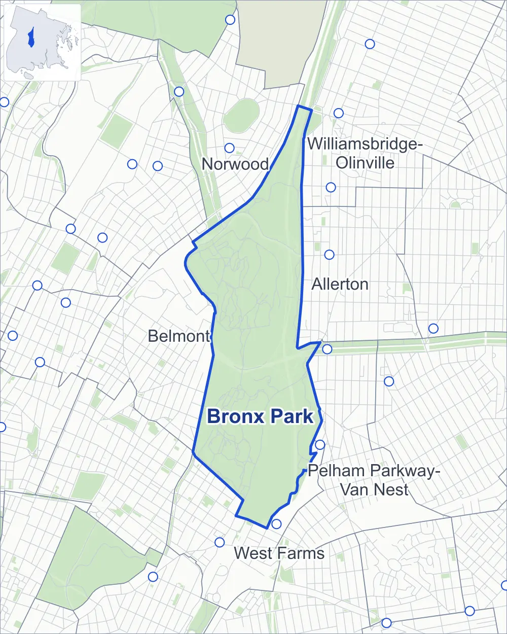
- Bronx Park
- A neighboring area
- Park
- Another station
Neighborhood areas and streets: NYC Department of City Planning. Parks: NYC Parks. Stations: MTA.
Neighboring areas
- Norwood north
- Williamsbridge-Olinville north
- Allerton northeast
- Pelham Parkway-Van Nest southeast
- West Farms south
- Belmont west
Getting around
Buses on 15 routes stop in or at the edge of Bronx Park.
- 14 local bus routes
- 1 express bus route
Local bus routes
- Bx9
- Bx12
- Bx12-SBS
- Bx19
- Bx22
- Bx25
- Bx26
- Bx28
- Bx38
- Bx39
- Bx40
- Bx42
- Q44-SBS
- T117
Express bus route
- BxM11
Safety record
Between 2021 and 2025, its corners averaged fewer police-reported crashes than the average Bronx corner.
- 134 police-reported crashes at its corners
- 2.7 a corner, on average
- 8.0 the average Bronx corner
- 43 corners with a clean record
Camera tickets
In 2025 the Department of Finance recorded no red-light, school-zone speed or bus-lane camera ticket at its corners.
Parks and landmarks
- Parkland
- 646.6 acres of Bronx Park, as NYC Parks maps it within the area's boundary
- Designated landmarks
- The Astor Court, Bronx Zoo; the Rockefeller Fountain, New York Zoological Park; the Astor Court, Bronx Zoo, Administration Building; and the Paul J. Rainey Memorial Gates, New York Zoological Park, among others
Streets and trees
- Trees
- 3,008 in NYC Parks' records, most often pin oak, ash and black cherry
- Street with the most corners
- Bronx River Parkway, with nine of the area's 49
- Height above sea level
- From 34 feet at Jungle World Road & Mitsubishi River Walk to 95 feet at Azalea Way & Garden Way
Bike share
By the station list of October 3, 2026, one bike-share station stands in Bronx Park.
- 1 bike-share station
Street corners
- African Plains Path & Asia Gate Entrance Path
- African Plains Path & Wildfowl Pond Path
- American Bison Path & Bronx River Gate Entrance Path
- Astor Court Path & American Bison Path
- Astor Court Path & Tiger Mountain Path
- Azalea Way & Daffodil Hill Way
- Azalea Way & Daffodil Hill Way at Stone Mill Road
- Azalea Way & Garden Way
- Azalea Way & Stone Mill Road
- Azalea Way & Sweet Gum Trail
- Big Bears Path & Himalayan Highlands Path
- Bird Alley Path & Birds of Prey Path
- Boston Road & Bronx River Parkway
- Boston Road & Bronx River Parkway (Exit 6, north-east)
- Boston Road & Bronx River Parkway (Exit 6, south-west)
- Boston Road & Jungle World Road
- Boston Road & Jungle World Road at Bronx River Parkway
- Bronx River Parkway & Boston Road
- Bronx River Parkway & Pelham Parkway
- Bronx River Parkway & Southern Boulevard
- Bronx River Parkway & Waring Avenue-New York Botanical Garden Pedestrian Overpass
- Bronx Zoo Path & Astor Court Path (north)
- Bronx Zoo Path & Astor Court Path (south)
- Bronx Zoo Path & Bird Alley Path
- Bronx Zoo Path & Butterfly Garden Path
- Bronx Zoo Path & Dancing Crane Plaza
- Bronx Zoo Path & Himalayan Highlands Path
- Bronx Zoo Path & Southern Boulevard Entrance Path
- Bronx Zoo Shuttle Path & Southern Boulevard Entrance Path
- East Fordham Road & Azalea Way
- Jungle World Road & Asia Gate Entrance Path
- Jungle World Road & Bronx River Gate Entrance Path
- Jungle World Road & Bronx Zoo Path
- Jungle World Road & Mitsubishi River Walk
- Magnolia Way & Bridge Trail
- Mosholu Parkway & Southern Boulevard
- Ranaqua Loop & Bronx River Parkway
- Rockefeller Fountain Circle & American Bison Path
- Rockefeller Fountain Circle & Astor Court Path
- Rockefeller Fountain Circle & Bird Alley Path
- Southern Boulevard & Garden Way
- Southern Boulevard Entrance Path & Bird Alley Path
- Sweet Gum Trail & Mill View Trail
- Tiger Mountain Path & American Bison Path
- Tiger Mountain Path & Big Bears Path
- Watson Drive & Botanical Garden Road
- Watson Drive & Conservatory Drive
- Watson Drive & Magnolia Way
- Wildfowl Pond Path & Dancing Crane Plaza
How the figures above are measured: Methodology.