Wakefield-Woodlawn
Neighborhood · Bronx
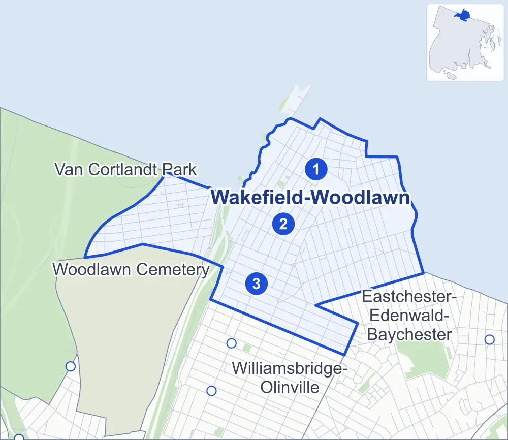
At the north end of the Bronx, Woodlawn Heights lies between Van Cortlandt Park, Woodlawn Cemetery and the Bronx River, while Wakefield stretches east from the Bronx River Parkway; the Westchester County line runs along the northern edge of both.
- 1.42 square miles
- 47,657 residents, 2020 Census
- 264 street corners
- 3 subway stations
- 7 bus routes
Wakefield is named for the Virginia plantation where George Washington was born, saw moderate growth after the New York and Harlem Railroad arrived around 1840 and became part of New York City in 1895. Woodlawn Heights, with Katonah Avenue as its main street, is a largely Irish American neighborhood, while Wakefield, served by the 2 train's Wakefield–241st Street station, has drawn large Caribbean and Guyanese communities since the 1980s.
Sources: Wakefield, Bronx (Wikipedia); Woodlawn Heights, Bronx (Wikipedia); About (Bronx Community Board 12).
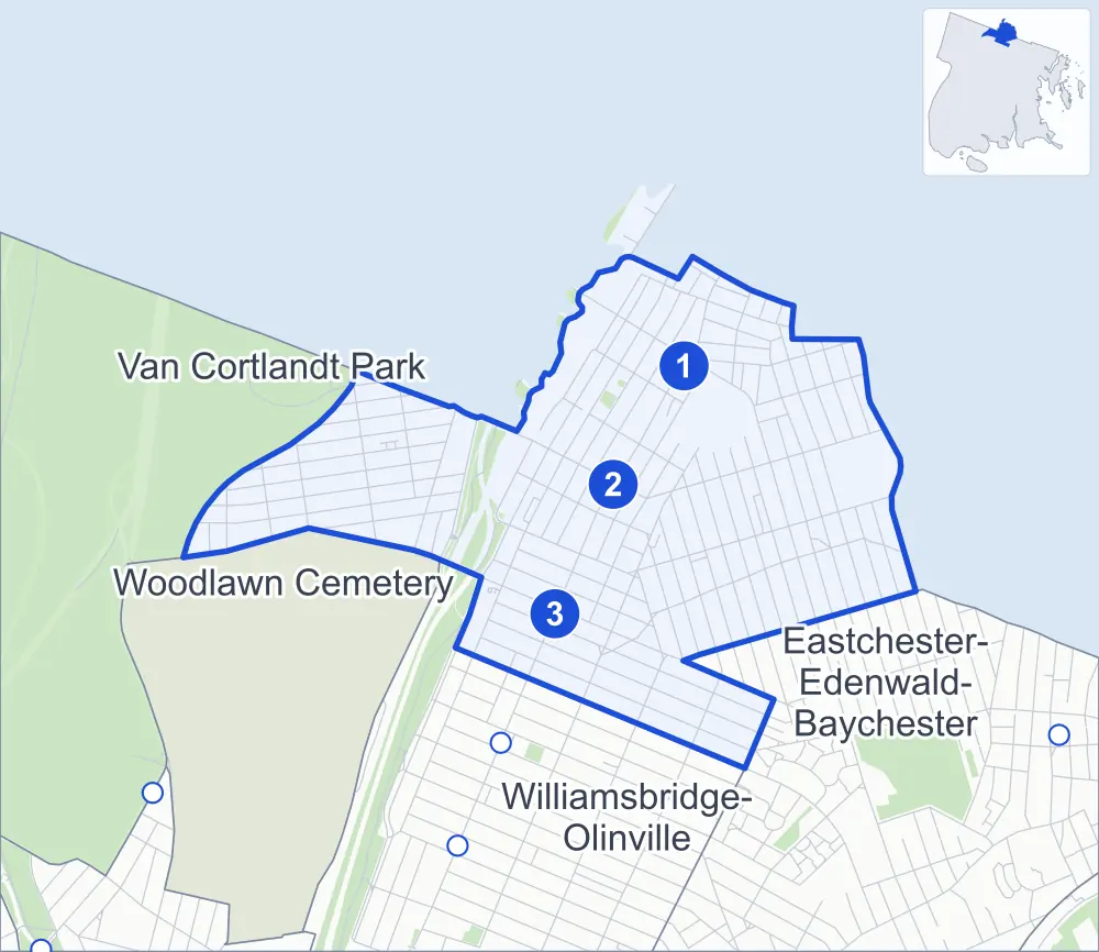
Wakefield-Woodlawn borders four areas, and Barnes Avenue holds more of its corners than any other street, 25 of 264.
- Wakefield-Woodlawn
- A neighboring area
- Park
- A station in the list
- Another station
Neighborhood areas and streets: NYC Department of City Planning. Parks: NYC Parks. Stations: MTA.
Neighboring areas
- Eastchester-Edenwald-Baychester southeast
- Williamsbridge-Olinville south
- Woodlawn Cemetery west
- Van Cortlandt Park west
Subway stations
- Wakefield-241 St lines 2
- Nereid Av lines 2 5
- 233 St lines 2 5 accessible
Getting around
Three subway stations and buses on seven routes stop in or at the edge of Wakefield-Woodlawn.
- 3 subway stations
- 1 of them listed by the MTA as fully accessible
- 5 local bus routes
- 2 express bus routes
Local bus routes
- Bx16
- Bx31
- Bx34
- Bx39
- T117
Express bus routes
- BxM4
- BxM11
Safety record
Between 2021 and 2025, its corners averaged fewer police-reported crashes than the average Bronx corner.
- 1,516 police-reported crashes at its corners
- 5.7 a corner, on average
- 8.0 the average Bronx corner
- 27 corners with a clean record
Signal or safety changes on City record, at 34 of its corners
- Accessible pedestrian signals
- 23
- Leading pedestrian intervals
- 17
- Turn calming
- 6
- Barnes Dance all-way crossings
- 2
- Safety Improvement Projects
- 2
Camera tickets
In 2025 its corners had more school-zone speed camera tickets than red-light or bus-lane tickets.
- 0 red-light camera tickets
- 24,835 school-zone speed camera tickets at 17 corners
- 0 bus-lane camera tickets
- Most speed tickets
- East 233rd Street & Katonah Avenue, 14,621
People and homes
The 2020 Census counted 47,657 residents in Wakefield-Woodlawn, about 33,600 per square mile.
- 18,601 homes, 2020 Census
- 1,178 homes added since April 2010, net, by City Planning's count
Half of its 6,270 residential lots hold buildings from 1930 or earlier, and 60% of them date from before 1940, by the City's tax lot records.
Parks
- Parkland
- 1.1 acres of Wakefield Playground, as NYC Parks maps it within Wakefield-Woodlawn
Streets and trees
- Trees
- 4,078 in NYC Parks' records, most often thornless honeylocust, London planetree and pin oak
- Street with the most corners
- Barnes Avenue, with 25 of the area's 264
- Height above sea level
- From 79 feet at Bronx River Parkway & Bronx River Greenway to 209 feet at Van Cortlandt Park East & East 236th Street
- Honorary street names
- 2 at its corners, enacted by local law
Schools and libraries
The City lists eight schools and two libraries in Wakefield-Woodlawn.
- Public schools
- 5
- Charter and private schools
- 3
- Libraries
- Wakefield Library and Woodlawn Heights Library
Public safety
How complaints are countedIn 2025 the NYPD recorded 888 major felonies at places in Wakefield-Woodlawn.
Recorded by the NYPD at places in Wakefield-Woodlawn
- 821 major felonies in 2024
- 2,187 other felonies, misdemeanors and violations in 2025
In 2025, on the streets along the edge of Wakefield-Woodlawn, the NYPD recorded another 117 major felonies. Counting the streets along its edge, in 2025 the NYPD recorded 21.1 major felonies for every thousand residents the 2020 Census counted in Wakefield-Woodlawn.
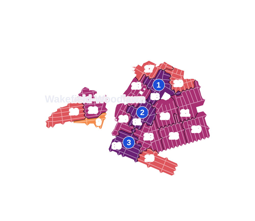
- 5 to 9
- 10 to 19
- 20 to 49
- 50 to 99
- 100 or more
- Not shaded: fewer than 5, held back under the rules in How complaints are counted, parks and public-housing grounds, and land in no patch
- Police precinct
- 47th
From January to June 2026 the NYPD recorded 354 major felonies at places in Wakefield-Woodlawn, against 442 in the same months of 2025.
Sources: the NYPD's Complaint Data Historic, updated April 28, 2026, and Complaint Data Current (Year To Date), updated July 27, 2026, on NYC Open Data. Figures to June 30, 2026.
Street corners
- Baldwin Street & Abbot Street
- Baldwin Street & Bradley Street
- Barnes Avenue & Boyd Avenue
- Barnes Avenue & Bronxwood Avenue
- Barnes Avenue & Bruner Avenue
- Barnes Avenue & Bussing Avenue
- Barnes Avenue & Cranford Avenue
- Barnes Avenue & Digney Avenue
- Barnes Avenue & East 229th Street
- Barnes Avenue & East 230th Street
- Barnes Avenue & East 231st Street
- Barnes Avenue & East 232nd Street
- Barnes Avenue & East 233rd Street
- Barnes Avenue & East 234th Street
- Barnes Avenue & East 235th Street
- Barnes Avenue & East 236th Street
- Barnes Avenue & East 237th Street
- Barnes Avenue & East 239th Street
- Barnes Avenue & East 241st Street
- Barnes Avenue & East 242nd Street
- Barnes Avenue & East 243rd Street
- Barnes Avenue & Gunther Avenue
- Barnes Avenue & Nereid Avenue
- Barnes Avenue & Penfield Street
- Barnes Avenue & St Ouen Street
- Barnes Avenue & Whitehall Place
- Barnes Avenue & Wickham Avenue
- Baychester Avenue & Bussing Avenue
- Baychester Avenue & Camp Street
- Baychester Avenue & East 241st Street
- Baychester Avenue & Nereid Avenue
- Baychester Avenue & Pitman Avenue
- Bronx Boulevard & East 234th Street
- Bronx Boulevard & East 236th Street
- Bronx Boulevard & East 237th Street
- Bronx Boulevard & East 239th Street
- Bronx Boulevard & East 240th Street
- Bronx Boulevard & East 241st Street
- Bronx Boulevard & East 242nd Street
- Bronx Boulevard & Nereid Avenue
- Bronx River Parkway & Bronx River Greenway
- Bronx River Parkway & Bronx River Greenway (Exit 10)
- Bronxwood Avenue & Bussing Avenue
- Bronxwood Avenue & East 229th Street
- Bronxwood Avenue & East 230th Street
- Bronxwood Avenue & East 231st Street
- Bronxwood Avenue & East 232nd Street
- Bronxwood Avenue & East 234th Street
- Bronxwood Avenue & East 235th Street
- Bronxwood Avenue & East 236th Street
- Bruner Avenue & Bussing Avenue
- Bruner Avenue & Nereid Avenue
- Bruner Avenue & Pitman Avenue
- Bullard Avenue & East 239th Street
- Bullard Avenue & East 240th Street
- Bussing Avenue & Boyd Avenue
- Bussing Avenue & Digney Avenue
- Bussing Avenue & East 232nd Street
- Bussing Avenue & East 234th Street
- Bussing Avenue & Hill Avenue
- Bussing Avenue & Seton Avenue
- Byron Avenue & Whitehall Place
- Carpenter Avenue & East 229th Street
- Carpenter Avenue & East 230th Street
- Carpenter Avenue & East 231st Street
- Carpenter Avenue & East 232nd Street
- Carpenter Avenue & East 234th Street
- Carpenter Avenue & East 235th Street
- Carpenter Avenue & East 236th Street
- Carpenter Avenue & East 237th Street
- Carpenter Avenue & East 239th Street
- Carpenter Avenue & East 240th Street
- Carpenter Avenue & East 241st Street
- Carpenter Avenue & East 242nd Street
- Carpenter Avenue & Nereid Avenue
- Cranford Avenue & Hoxie Street
- Cranford Avenue & Osman Place
- De Reimer Avenue & Bussing Avenue
- De Reimer Avenue & Bussing Place
- De Reimer Avenue & Camp Street
- De Reimer Avenue & Edenwald Avenue
- De Reimer Avenue & Nereid Avenue
- De Reimer Avenue & Pitman Avenue
- East 230th Street & Lowerre Place
- East 233rd Street & Bronxwood Avenue
- East 233rd Street & Bruner Avenue
- East 233rd Street & Bussing Avenue
- East 233rd Street & Byron Avenue
- East 233rd Street & Carpenter Avenue
- East 233rd Street & East 234th Street
- East 233rd Street & Edenwald Avenue
- East 233rd Street & Herkimer Place
- East 233rd Street & Katonah Avenue
- East 233rd Street & Kepler Avenue
- East 233rd Street & Napier Avenue
- East 233rd Street & Oneida Avenue
- East 233rd Street & Peters Place
- East 233rd Street & Van Cortlandt Park East
- East 233rd Street & Vireo Avenue
- East 234th Street & Byron Avenue
- East 234th Street & Katonah Avenue
- East 234th Street & Peters Place
- East 234th Street & Vireo Avenue
- East 235th Street & Byron Avenue
- East 235th Street & Herkimer Place
- East 235th Street & Katonah Avenue
- East 235th Street & Kepler Avenue
- East 235th Street & Martha Avenue
- East 235th Street & Napier Avenue
- East 235th Street & Oneida Avenue
- East 235th Street & Vireo Avenue
- East 236th Street & Bullard Avenue
- East 236th Street & Byron Avenue
- East 236th Street & Furman Avenue
- East 236th Street & Katonah Avenue
- East 236th Street & Kepler Avenue
- East 236th Street & Martha Avenue
- East 236th Street & Matilda Avenue
- East 236th Street & Napier Avenue
- East 236th Street & Oneida Avenue
- East 236th Street & Richardson Avenue
- East 236th Street & Vireo Avenue
- East 237th Street & Bullard Avenue
- East 237th Street & Byron Avenue
- East 237th Street & Furman Avenue
- East 237th Street & Katonah Avenue
- East 237th Street & Kepler Avenue
- East 237th Street & Martha Avenue
- East 237th Street & Matilda Avenue
- East 237th Street & Napier Avenue
- East 237th Street & Oneida Avenue
- East 237th Street & Richardson Avenue
- East 237th Street & Vireo Avenue
- East 238th Street & Katonah Avenue
- East 238th Street & Kepler Avenue
- East 238th Street & Martha Avenue
- East 238th Street & Oneida Avenue
- East 238th Street & Vireo Avenue
- East 239th Street & Byron Avenue
- East 239th Street & Katonah Avenue
- East 239th Street & Kepler Avenue
- East 239th Street & Martha Avenue
- East 239th Street & Richardson Avenue
- East 239th Street & Vireo Avenue
- East 240th Street & Garden Place
- East 240th Street & Katonah Avenue
- East 240th Street & Martha Avenue
- East 240th Street & Vireo Avenue
- East 241st Street & Bullard Avenue
- East 241st Street & Cranford Avenue
- East 241st Street & Furman Avenue
- East 241st Street & Hill Avenue
- East 241st Street & Hoxie Street
- East 241st Street & Katonah Avenue
- East 241st Street & Martha Avenue
- East 241st Street & Matilda Avenue
- East 241st Street & Monticello Avenue
- East 241st Street & Mundy Lane
- East 241st Street & Osman Place
- East 241st Street & Richardson Avenue
- East 241st Street & Seton Avenue
- East 241st Street & Wilder Avenue
- East 242nd Street & Osgood Street
- East 242nd Street & Robertson Street
- East 243rd Street & Osgood Street
- Edenwald Avenue & Boyd Avenue
- Edson Avenue & Bussing Avenue
- Edson Avenue & Edenwald Avenue
- Edson Avenue & Nereid Avenue
- Edson Avenue & Pitman Avenue
- Ely Avenue & Bussing Avenue
- Ely Avenue & Edenwald Avenue
- Ely Avenue & Nereid Avenue
- Ely Avenue & Pitman Avenue
- Furman Avenue & East 239th Street
- Furman Avenue & East 240th Street
- Grace Avenue & Bussing Avenue
- Grace Avenue & Nereid Avenue
- Grace Avenue & Pitman Avenue
- Gunther Avenue & Bussing Avenue
- Gunther Avenue & Pitman Avenue
- Hill Avenue & Cranford Avenue
- Hill Avenue & Edenwald Avenue
- Hill Avenue & Pitman Avenue
- Laconia Avenue & East 229th Street
- Laconia Avenue & East 230th Street
- Matilda Avenue & East 239th Street
- Matilda Avenue & East 240th Street
- Matilda Avenue & East 242nd Street
- Monticello Avenue & Bussing Avenue
- Monticello Avenue & Cranford Avenue
- Monticello Avenue & Edenwald Avenue
- Monticello Avenue & Pitman Avenue
- Murdock Avenue & Bussing Avenue
- Murdock Avenue & Cranford Avenue
- Murdock Avenue & East 241st Street
- Murdock Avenue & East 242nd Street
- Murdock Avenue & Edenwald Avenue
- Murdock Avenue & Nereid Avenue
- Murdock Avenue & Penfield Street
- Murdock Avenue & Pitman Avenue
- Nereid Avenue & Bullard Avenue
- Nereid Avenue & Byron Avenue
- Nereid Avenue & Furman Avenue
- Nereid Avenue & Hill Avenue
- Nereid Avenue & Matilda Avenue
- Nereid Avenue & Monticello Avenue
- Nereid Avenue & Mundy Lane
- Nereid Avenue & Richardson Avenue
- Nereid Avenue & Seton Avenue
- Nereid Avenue & Wilder Avenue
- Paulding Avenue & East 230th Street
- Paulding Avenue & East 231st Street
- Paulding Avenue & East 232nd Street
- Pitman Avenue & Boyd Avenue
- Pitman Avenue & Digney Avenue
- Richardson Avenue & East 240th Street
- Richardson Avenue & East 242nd Street
- Seton Avenue & Cranford Avenue
- Seton Avenue & Edenwald Avenue
- Seton Avenue & Pitman Avenue
- Van Cortlandt Park East & East 235th Street
- Van Cortlandt Park East & East 236th Street
- Van Cortlandt Park East & East 238th Street
- Van Cortlandt Park East & East 239th Street
- Van Cortlandt Park East & East 240th Street
- Van Cortlandt Park East & East 241st Street
- Van Cortlandt Park East & East 242nd Street
- Van Cortlandt Park East & Napier Avenue
- Van Cortlandt Park East & Oneida Avenue
- Van Cortlandt Park East & Van Cortlandt Park Path
- Webster Avenue & Bronx River Parkway
- Webster Avenue & Bronx River Parkway (Exit 10)
- Webster Avenue & East 234th Street
- Webster Avenue & East 235th Street
- Webster Avenue & East 236th Street
- Webster Avenue & Nereid Avenue
- White Plains Road & East 230th Street
- White Plains Road & East 231st Street
- White Plains Road & East 232nd Street
- White Plains Road & East 233rd Street
- White Plains Road & East 234th Street
- White Plains Road & East 235th Street
- White Plains Road & East 236th Street
- White Plains Road & East 237th Street
- White Plains Road & East 239th Street
- White Plains Road & East 240th Street
- White Plains Road & East 241st Street
- White Plains Road & East 242nd Street
- White Plains Road & East 243rd Street
- White Plains Road & Nereid Avenue
- White Plains Road & Penfield Street
- White Plains Road & St Ouen Street
- Wickham Avenue & Bussing Avenue
- Wickham Avenue & Nereid Avenue
- Wickham Avenue & Pitman Avenue
- Wilder Avenue & Bussing Avenue
- Wilder Avenue & Camp Street
- Wilder Avenue & Cranford Avenue
- Wilder Avenue & East 242nd Street
- Wilder Avenue & Edenwald Avenue
- Wilder Avenue & Penfield Street
- Wilder Avenue & Pitman Avenue
- Wilder Avenue & St Ouen Street
How the figures above are measured: Methodology.