Kingsbridge-Marble Hill
Neighborhood · Bronx
In the northwest Bronx, Kingsbridge-Marble Hill pairs Kingsbridge with Marble Hill, which the Broadway Bridge connects to the rest of Manhattan.
- 0.44 square miles
- 22,807 residents, 2020 Census
- 64 street corners
- 4 subway stations
- 10 bus routes
Kingsbridge takes its name from the King's Bridge, which manor lord Frederick Philipse built across Spuyten Duyvil Creek in the late 1600s near today's West 230th Street, and which was part of the Boston Post Road. Marble Hill, named for the marble deposits beneath it, was cut off from Manhattan Island when the Harlem River Ship Canal opened in 1895. Once the old creek bed was filled, it became joined to the Bronx mainland, yet it remains part of the borough of Manhattan.
Sources: Kingsbridge, Bronx (Wikipedia); Inwood Hill Park Highlights (NYC Parks); Marble Hill, Manhattan (Wikipedia).
Kingsbridge-Marble Hill borders four areas, and Broadway holds more of its corners than any other street, 19 of 81.
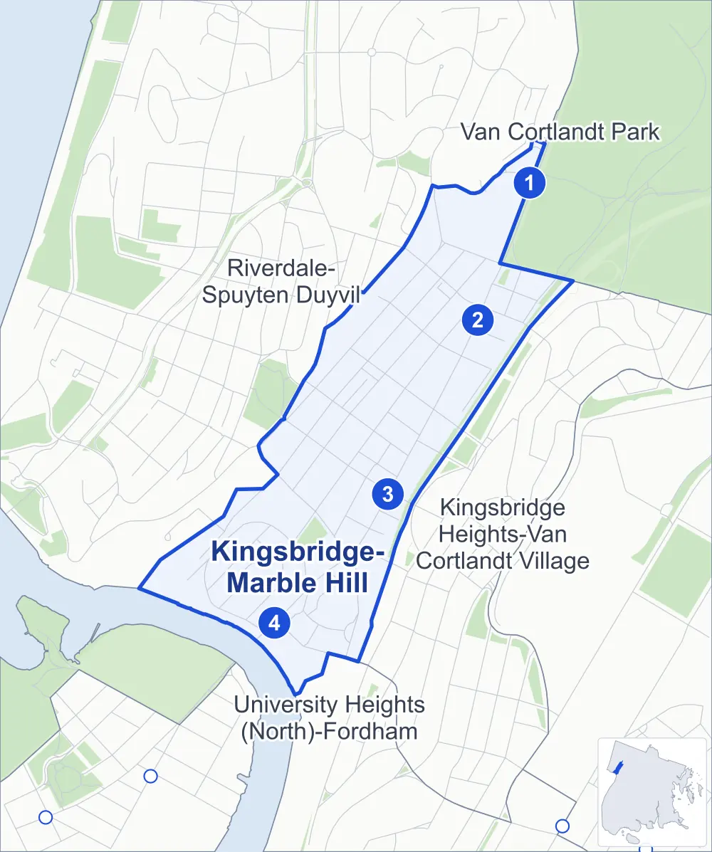
- Kingsbridge-Marble Hill
- A neighboring area
- Park
- A station in the list
- Another station
Neighborhood areas and streets: NYC Department of City Planning. Parks: NYC Parks. Stations: MTA.
Neighboring areas
Subway stations
- Van Cortlandt Park-242 St lines 1
- 238 St lines 1
- 231 St lines 1 accessible
- Marble Hill-225 St lines 1
Getting around
Four subway stations and buses on ten routes stop in or at the edge of Kingsbridge-Marble Hill.
- 4 subway stations
- 1 of them listed by the MTA as fully accessible
- 7 local bus routes
- 3 express bus routes
Local bus routes
- Bx1
- Bx2
- Bx3
- Bx7
- Bx9
- Bx10
- Bx20
Express bus routes
- BxM1
- BxM2
- BxM18
Safety record
Between 2021 and 2025, its corners averaged more police-reported crashes than the average Bronx corner.
- 756 police-reported crashes at its corners
- 9.3 a corner, on average
- 8.0 the average Bronx corner
- 2 corners with a clean record
Signal or safety changes on City record, at 18 of its corners
- Leading pedestrian intervals
- 11
- Accessible pedestrian signals
- 9
- Enhanced crossings
- 2
- Safety Improvement Projects
- 2
- Turn calming
- 1
Camera tickets
In 2025 its corners had more school-zone speed camera tickets than red-light or bus-lane tickets.
- 0 red-light camera tickets
- 8,459 school-zone speed camera tickets at seven corners
- 0 bus-lane camera tickets
- Most speed tickets
- Broadway & Manhattan College Parkway, 3,964
People and homes
The 2020 Census counted 22,807 residents in Kingsbridge-Marble Hill, about 51,800 per square mile.
- 9,495 homes, 2020 Census
- 605 homes added since April 2010, net, by City Planning's count
Half of its 679 residential lots hold buildings from 1930 or earlier, and 67% of them date from before 1940, by the City's tax lot records.
NYCHA development
NYCHA's Marble Hill development lies wholly or partly within Kingsbridge-Marble Hill.
Parks
- Parkland
- 2.2 acres of NYC Parks property
- The largest pieces
- Marble Hill Playground (1.8 acres) and Van Cortlandt's Tail (0.3 acre)
Streets and trees
- Trees
- 1,324 in NYC Parks' records, most often pin oak, thornless honeylocust and London planetree
- Street with the most corners
- Broadway, with 19 of the area's 81
- Height above sea level
- From 13 feet at Tibbett Avenue & West 234th Street to 109 feet at West 236th Street & Waldo Avenue
- Honorary street names
- 9 at its corners, enacted by local law
Schools and libraries
The City lists 13 schools and one library in Kingsbridge-Marble Hill.
- Public schools
- 7
- Charter and private schools
- 6
- Library
- Kingsbridge Library
Bike share
By the station list of October 3, 2026, 14 bike-share stations stand in Kingsbridge-Marble Hill.
- 14 bike-share stations
Public safety
How complaints are countedIn 2025 the NYPD recorded 329 major felonies at places in Kingsbridge-Marble Hill.
Recorded by the NYPD at places in Kingsbridge-Marble Hill
- 517 major felonies in 2024 188 fewer in 2025
- 1,520 other felonies, misdemeanors and violations in 2025
In 2025, on the streets along the edge of Kingsbridge-Marble Hill, the NYPD recorded another 38 major felonies.
- Police precinct
- 50th
From January to June 2026 the NYPD recorded 161 major felonies at places in Kingsbridge-Marble Hill, against 183 in the same months of 2025.
Sources: the NYPD's Complaint Data Historic, updated April 28, 2026, and Complaint Data Current (Year To Date), updated July 27, 2026, on NYC Open Data. Figures to June 30, 2026.
Street corners
- Broadway & Kimberly Place
- Broadway & Manhattan College Parkway
- Broadway & Naples Terrace
- Broadway & Verveelen Place
- Broadway & West 230th Street
- Broadway & West 231st Street
- Broadway & West 232nd Street
- Broadway & West 233rd Street
- Broadway & West 234th Street
- Broadway & West 236th Street
- Broadway & West 237th Street
- Broadway & West 238th Street
- Broadway & West 239th Street
- Broadway & West 240th Street
- Broadway & West 242nd Street
- Corlear Avenue & West 234th Street
- Corlear Avenue & West 240th Street
- Exterior Street & Broadway
- Godwin Terrace & Kimberly Place
- Godwin Terrace & Naples Terrace
- Irwin Avenue & West 234th Street
- Irwin Avenue & West 240th Street
- Irwin Avenue & West 240th Street at Waldo Walk
- Kingsbridge Avenue & Naples Terrace
- Kingsbridge Avenue & West 233rd Street
- Kingsbridge Avenue & West 234th Street
- Manhattan College Parkway & Pedestrian Overpass
- Manhattan College Parkway & Waldo Walk
- Riverdale Avenue & Irwin Avenue
- Riverdale Avenue & West 231st Street
- Tibbett Avenue & West 230th Street
- Tibbett Avenue & West 231st Street
- Tibbett Avenue & West 232nd Street
- Tibbett Avenue & West 234th Street
- Tibbett Avenue & West 236th Street
- Tibbett Avenue & West 238th Street
- Tibbett Avenue & West 240th Street
- Van Cortlandt Park South & Major Deegan Expressway
- Van Cortlandt Park South & Old Putnam Trail
- Van Cortlandt Park South & Putnam Avenue West
- Van Cortlandt Park South & Review Place
- West 230th Street & Corlear Avenue
- West 230th Street & Godwin Terrace
- West 230th Street & Kingsbridge Avenue
- West 231st Street & Corlear Avenue
- West 231st Street & Godwin Terrace
- West 231st Street & Irwin Avenue
- West 231st Street & Kingsbridge Avenue
- West 232nd Street & Corlear Avenue
- West 232nd Street & Godwin Terrace
- West 232nd Street & Irwin Avenue
- West 232nd Street & Kingsbridge Avenue
- West 236th Street & Corlear Avenue
- West 236th Street & Irwin Avenue
- West 236th Street & Kingsbridge Avenue
- West 236th Street & Waldo Avenue
- West 238th Street & Corlear Avenue
- West 238th Street & Irwin Avenue
- West 238th Street & Kingsbridge Avenue
- West 238th Street & Putnam Avenue West
- West 238th Street & Review Place
- West 238th Street & Waldo Avenue
- West 239th Street & Putnam Avenue West
- West 239th Street & Review Place
How the figures above are measured: Methodology.