University Heights (North)-Fordham
Neighborhood · Bronx
University Heights (North)-Fordham spans the Bronx blocks between Fordham Road and Kingsbridge Road, reaching from the Harlem River east past the Grand Concourse.
- 0.66 square miles
- 46,538 residents, 2020 Census
- 97 street corners
- 2 subway stations
- 17 bus routes
The Fordham section began to grow in the 1930s, when families moved in, drawn by modern housing and convenient subway access to Manhattan. On the Grand Concourse stands the Edgar Allan Poe Cottage, where the writer lived from 1846 to 1849, run as a museum by the Bronx County Historical Society since 1975. To the northwest rises the Kingsbridge Armory, a fortress-like drill hall built from 1912 to 1917 for the Eighth Regiment and said to be the world's largest armory.
Sources: Kingsbridge Heights (Bronx Community Board 7); Fordham (Bronx Community Board 7); Poe Cottage (The Bronx County Historical Society); Kingsbridge Armory (LP-0823), Designation Number 2, September 24, 1974 (NYC Landmarks Preservation Commission).
University Heights (North)-Fordham borders six areas, and West Fordham Road holds more of its corners than any other street, 17 of 97.
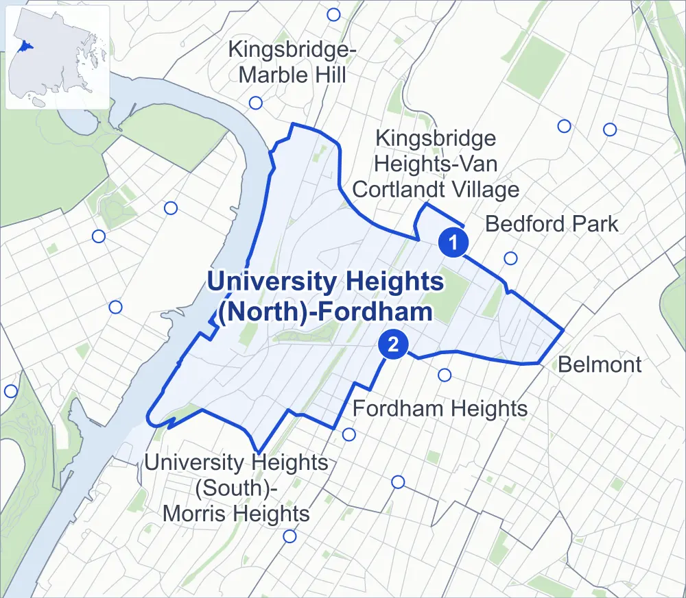
- University Heights (North)-Fordham
- A neighboring area
- Park
- A station in the list
- Another station
Neighborhood areas and streets: NYC Department of City Planning. Parks: NYC Parks. Stations: MTA.
Neighboring areas
- Kingsbridge Heights-Van Cortlandt Village north
- Kingsbridge-Marble Hill north
- Bedford Park east
- Belmont east
- Fordham Heights southeast
- University Heights (South)-Morris Heights southwest
Subway stations
- Kingsbridge Rd lines 4
- Fordham Rd lines 4 accessible
Getting around
Two subway stations and buses on 17 routes stop in or at the edge of University Heights (North)-Fordham.
- 2 subway stations
- 1 of them listed by the MTA as fully accessible
- 15 local bus routes
- 2 express bus routes
Local bus routes
- Bx1
- Bx2
- Bx3
- Bx9
- Bx12
- Bx12-SBS
- Bx22
- Bx28
- Bx32
- Bx34
- Bx38
- Bx40
- Bx41
- Bx42
- BX95
Express bus routes
- BxM3
- BxM4
Safety record
Between 2021 and 2025, its corners averaged more police-reported crashes than the average Bronx corner.
- 1,819 police-reported crashes at its corners
- 18.8 a corner, on average
- 8.0 the average Bronx corner
- 7 corners with a clean record
Signal or safety changes on City record, at 28 of its corners
- Leading pedestrian intervals
- 19
- Accessible pedestrian signals
- 12
- Turn calming
- 5
- Barnes Dance all-way crossings
- 4
- Safety Improvement Projects
- 4
Camera tickets
In 2025 its corners had more school-zone speed camera tickets than red-light or bus-lane tickets.
- 8,192 red-light camera tickets at one corner
- 20,279 school-zone speed camera tickets at seven corners
- 2,120 bus-lane camera tickets at three corners
- Most red-light tickets
- Cedar Avenue & West Fordham Road, 8,192
- Most speed tickets
- Bailey Avenue & West 193rd Street, 7,909
- Most bus-lane tickets
- Andrews Avenue North & West Fordham Road, 1,692
People and homes
The 2020 Census counted 46,538 residents in University Heights (North)-Fordham, about 70,500 per square mile.
- 15,889 homes, 2020 Census
- 1,585 homes added since April 2010, net, by City Planning's count
Half of its 882 residential lots hold buildings from 1915 or earlier, and 83% of them date from before 1940, by the City's tax lot records.
Parks and landmarks
- Parkland
- 31.9 acres of NYC Parks property
- The largest pieces
- St. James Park (11.6 acres), Devoe Park (5.5 acres) and Fordham Landing Playground (4.5 acres)
- Designated landmarks
- The Apple Bank, the Edgar Allan Poe Cottage and the Eighth Coastal Artillery Armory
Streets and trees
- Trees
- 2,819 in NYC Parks' records, most often thornless honeylocust, pin oak and London planetree
- Street with the most corners
- West Fordham Road, with 17 of the area's 97
- Height above sea level
- From 28 feet at Bailey Avenue & West 193rd Street to 163 feet at West 183rd Street & Loring Place North
- Honorary street names
- 14 at its corners, enacted by local law
Schools and libraries
The City lists nine schools and one library in University Heights (North)-Fordham.
- Public schools
- 6
- Charter and private schools
- 3
- Library
- Bronx Library Center
Bike share
By the station list of October 3, 2026, 16 bike-share stations stand in University Heights (North)-Fordham.
- 16 bike-share stations
Public safety
How complaints are countedIn 2025 the NYPD recorded 804 major felonies at places in University Heights (North)-Fordham.
Recorded by the NYPD at places in University Heights (North)-Fordham
- 772 major felonies in 2024
- 2,019 other felonies, misdemeanors and violations in 2025
In 2025, on the streets along the edge of University Heights (North)-Fordham, the NYPD recorded another 396 major felonies. Counting the streets along its edge, in 2025 the NYPD recorded 25.8 major felonies for every thousand residents the 2020 Census counted in University Heights (North)-Fordham.
- Police precincts
- 52nd (most of the area), 46th
From January to June 2026 the NYPD recorded 352 major felonies at places in University Heights (North)-Fordham, against 366 in the same months of 2025.
Sources: the NYPD's Complaint Data Historic, updated April 28, 2026, and Complaint Data Current (Year To Date), updated July 27, 2026, on NYC Open Data. Figures to June 30, 2026.
Street corners
- Andrews Avenue North & West 183rd Street
- Andrews Avenue North & West Fordham Road
- Aqueduct Avenue East & Evelyn Place
- Aqueduct Avenue East & North Street
- Aqueduct Avenue West & West 190th Street
- Aqueduct Avenue West & West 192nd Street
- Bailey Avenue & Heath Avenue
- Bailey Avenue & West 193rd Street
- Bainbridge Avenue & East 193rd Street
- Bainbridge Avenue & East 194th Street
- Bainbridge Avenue & Library Lane
- Briggs Avenue & East 194th Street
- Briggs Avenue & East Kingsbridge Road
- Cedar Avenue & Landing Road
- Cedar Avenue & West 182nd Street
- Cedar Avenue & West Fordham Road
- Creston Avenue & East 190th Street
- Creston Avenue & East 191st Street
- Creston Avenue & East 192nd Street
- Creston Avenue & East 193rd Street
- Creston Avenue & East Kingsbridge Road
- Davidson Avenue & West 184th Street
- Davidson Avenue & West 190th Street
- Davidson Avenue & West 192nd Street
- Davidson Avenue & West Fordham Road
- Davidson Avenue & West Kingsbridge Road
- Decatur Avenue & East 193rd Street
- Decatur Avenue & East 194th Street
- East Fordham Road & Creston Avenue
- East Fordham Road & East 190th Street
- East Fordham Road & East Kingsbridge Road
- East Fordham Road & Morris Avenue
- East Fordham Road & Tiebout Avenue
- East Fordham Road & Valentine Avenue
- East Fordham Road & Walton Avenue
- East Kingsbridge Road & East 192nd Street
- East Kingsbridge Road & Elm Place
- East Kingsbridge Road & Library Lane
- Exterior Street & West Fordham Road
- Exterior Street & West Fordham Road at University Heights Bridge
- Exterior Street & West Kingsbridge Road
- Grand Avenue & Evelyn Place
- Grand Avenue & North Street
- Grand Avenue & West 183rd Street
- Grand Avenue & West 184th Street
- Grand Avenue & West 188th Street
- Grand Avenue & West 190th Street
- Grand Avenue & West 192nd Street
- Grand Avenue & West Fordham Road
- Grand Concourse & East 192nd Street
- Heath Avenue & Kingsbridge Terrace
- Heath Avenue & West 193rd Street
- Jerome Avenue & 190th Street
- Jerome Avenue & East 193rd Street
- Jerome Avenue & West 192nd Street
- Major Deegan Expressway & Landing Road
- Major Deegan Expressway & West Fordham Road
- Major Deegan Expressway & West Kingsbridge Road
- Marion Avenue & Dorothea Place
- Marion Avenue & East 193rd Street
- Marion Avenue & East 194th Street
- Morris Avenue & East 190th Street
- Morris Avenue & East 193rd Street
- Morris Avenue & East Kingsbridge Road
- Poe Place & Library Lane
- Reservoir Avenue & Grand Avenue
- Sedgwick Avenue & Bailey Avenue
- Sedgwick Avenue & Fordham Hill Oval
- Sedgwick Avenue & Hall of Fame Terrace
- Sedgwick Avenue & Webb Avenue
- Sedgwick Avenue & West 183rd Street
- Sedgwick Avenue & West Fordham Road
- University Avenue & Father Zeiser Place
- University Avenue & West 183rd Street
- University Avenue & West 188th Street
- University Avenue & West 190th Street
- University Avenue & West 192nd Street
- University Avenue & West Fordham Road
- University Avenue & West Kingsbridge Road
- Valentine Avenue & East 192nd Street
- Valentine Avenue & East 194th Street
- Valentine Avenue & East Kingsbridge Road
- Webb Avenue & Devoe Park Path
- Webb Avenue & Devoe Terrace
- Webb Avenue & Father Zeiser Place
- Webb Avenue & Fordham Hill Oval
- Webb Avenue & US Veterans Hospital Driveway
- Webb Avenue & West 190th Street
- West 183rd Street & Loring Place North
- West 190th Street & Devoe Terrace
- West Fordham Road & Devoe Park Path
- West Fordham Road & Hampden Place
- West Fordham Road & Landing Road
- West Fordham Road & Loring Place North
- West Fordham Road & Major Deegan Expressway
- West Fordham Road & Major Deegan Expressway (Exit 9, W Fordham Road)
- West Fordham Road & Major Deegan Expressway (Exit 9, W Fordham)
How the figures above are measured: Methodology.