University Heights (South)-Morris Heights
Neighborhood · Bronx
On the Harlem River bluffs of the west Bronx, University Heights (South)-Morris Heights takes in Morris Heights and the southern part of University Heights.
- 0.70 square miles
- 54,682 residents, 2020 Census
- 147 street corners
- 2 subway stations
- 10 bus routes
The hilltop, then known as Fordham Heights and later renamed University Heights, became home to New York University's uptown campus in 1894; Stanford White's domed Gould Memorial Library there, with the Hall of Fame behind it, has belonged to Bronx Community College since 1973. Along the river lies the 25-acre Roberto Clemente State Park, opened that same year, and close by stands 1520 Sedgwick Avenue, where a recreation-room party in August 1973 is celebrated as the birthplace of hip hop.
Sources: Gould Memorial Library (LP-1087), Designation List 146, August 11, 1981 (NYC Landmarks Preservation Commission); Roberto Clemente State Park (New York State Parks); 50 years of Hip Hop: Five iconic landmarks that live in hip hop history (ABC7 New York).
University Heights (South)-Morris Heights borders five areas, and Cross Bronx Expressway holds more of its corners than any other street, 20 of 147.
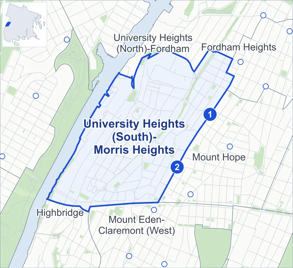
- University Heights (South)-Morris Heights
- A neighboring area
- Park
- A station in the list
- Another station
Neighborhood areas and streets: NYC Department of City Planning. Parks: NYC Parks. Stations: MTA.
Neighboring areas
- University Heights (North)-Fordham north
- Fordham Heights northeast
- Mount Hope east
- Mount Eden-Claremont (West) south
- Highbridge southwest
Subway stations
- Burnside Av lines 4
- 176 St lines 4
Getting around
Two subway stations and buses on ten routes stop in or at the edge of University Heights (South)-Morris Heights.
- 2 subway stations
- 10 local bus routes
Local bus routes
- Bx3
- Bx11
- Bx13
- Bx18A
- Bx18B
- Bx32
- Bx35
- Bx36
- Bx40
- Bx42
Safety record
Between 2021 and 2025, its corners averaged more police-reported crashes than the average Bronx corner.
- 1,425 police-reported crashes at its corners
- 9.7 a corner, on average
- 8.0 the average Bronx corner
- 34 corners with a clean record
Signal or safety changes on City record, at 36 of its corners
- Leading pedestrian intervals
- 23
- Accessible pedestrian signals
- 20
- Turn calming
- 6
- Barnes Dance all-way crossings
- 4
- Safety Improvement Projects
- 3
- Enhanced crossings
- 1
Camera tickets
In 2025 its corners had more school-zone speed camera tickets than red-light or bus-lane tickets.
- 0 red-light camera tickets
- 2,583 school-zone speed camera tickets at one corner
- 0 bus-lane camera tickets
- Most speed tickets
- University Avenue & West Burnside Avenue at West 179th Street, 2,583
People and homes
The 2020 Census counted 54,682 residents in University Heights (South)-Morris Heights, about 78,100 per square mile.
- 19,536 homes, 2020 Census
- 2,582 homes added since April 2010, net, by City Planning's count
Half of its 1,321 residential lots hold buildings from 1925 or earlier, and 64% of them date from before 1940, by the City's tax lot records.
NYCHA developments
NYCHA's Sedgwick development lies wholly or partly within University Heights (South)-Morris Heights, as does one more that NYCHA names by a building's address.
Parks and landmarks
- Parkland
- 16.2 acres of NYC Parks property
- The largest pieces
- Aqueduct Walk (5.8 acres), Bridge Park (3.5 acres) and Cedar Playground (1.8 acres)
- Designated landmarks
- The Messiah Home for Children; the Begrisch Hall, New York University; the Hall of Languages, New York University; and the Cornelius Baker Hall of Philosophy, New York University, among others
Streets and trees
- Trees
- 2,923 in NYC Parks' records, most often thornless honeylocust, Japanese zelkova and London planetree
- Street with the most corners
- Cross Bronx Expressway, with 20 of the area's 147
- Height above sea level
- From 25 feet at Cedar Avenue & West Tremont Avenue to 176 feet at Hall of Fame Terrace & Loring Place North
- Honorary street names
- 7 at its corners, enacted by local law
Schools and libraries
The City lists 17 schools and two libraries in University Heights (South)-Morris Heights.
- Public schools
- 16
- Charter or private school
- 1
- Libraries
- Francis Martin Library and Sedgwick Library
Bike share
By the station list of October 3, 2026, 21 bike-share stations stand in University Heights (South)-Morris Heights.
- 21 bike-share stations
Public safety
How complaints are countedIn 2025 the NYPD recorded 850 major felonies at places in University Heights (South)-Morris Heights.
Recorded by the NYPD at places in University Heights (South)-Morris Heights
- 723 major felonies in 2024
- 2,395 other felonies, misdemeanors and violations in 2025
In 2025, on the streets along the edge of University Heights (South)-Morris Heights, the NYPD recorded another 170 major felonies. Counting the streets along its edge, in 2025 the NYPD recorded 18.7 major felonies for every thousand residents the 2020 Census counted in University Heights (South)-Morris Heights.
- Police precincts
- 46th (most of the area), 44th
From January to June 2026 the NYPD recorded 408 major felonies at places in University Heights (South)-Morris Heights, against 430 in the same months of 2025.
Sources: the NYPD's Complaint Data Historic, updated April 28, 2026, and Complaint Data Current (Year To Date), updated July 27, 2026, on NYC Open Data. Figures to June 30, 2026.
Street corners
- Andrews Avenue North & Hall of Fame Terrace
- Andrews Avenue South & Tenney Place
- Andrews Avenue South & West 175th Street
- Andrews Avenue South & West 176th Street
- Andrews Avenue South & West 179th Street
- Andrews Avenue South & West Burnside Avenue
- Aqueduct Avenue East & Buchanan Place
- Aqueduct Avenue East & Clinton Place
- Aqueduct Avenue East & West 181st Street
- Aqueduct Avenue East & West 182nd Street
- Aqueduct Avenue East & West 183rd Street
- Billingsley Terrace & Phelan Place (north-east)
- Billingsley Terrace & Phelan Place (south-west)
- Bronx Community College Driveway & Wiegand Place
- Cedar Avenue & West 179th Street
- Cedar Avenue & West Tremont Avenue
- Cross Bronx Expressway & Jesup Avenue
- Cross Bronx Expressway & Macombs Road
- Cross Bronx Expressway & Nelson Avenue
- Cross Bronx Expressway & Plimpton Avenue
- Cross Bronx Expressway & Shakespeare Avenue
- Cross Bronx Expressway & University Avenue
- Cross Bronx Expressway & Washington Bridge Bike Path
- Cross Bronx Expressway & Washington Bridge Pedestrian Path
- Davidson Avenue & Buchanan Place
- Davidson Avenue & Clinton Place
- Davidson Avenue & Featherbed Lane
- Davidson Avenue & West 174th Street
- Davidson Avenue & West 176th Street
- Davidson Avenue & West 177th Street
- Davidson Avenue & West 180th Street
- Davidson Avenue & West 181st Street
- Davidson Avenue & West 182nd Street
- Davidson Avenue & West 183rd Street
- Davidson Avenue & West Burnside Avenue
- Davidson Avenue & West Clifford Place
- Davidson Avenue & West Tremont Avenue
- Featherbed Lane & Jesup Avenue
- Grand Avenue & Buchanan Place
- Grand Avenue & Clinton Place
- Grand Avenue & Macombs Road
- Grand Avenue & West 174th Street
- Grand Avenue & West 175th Street
- Grand Avenue & West 176th Street
- Grand Avenue & West 180th Street
- Grand Avenue & West 181st Street
- Grand Avenue & West 182nd Street
- Grand Avenue & West Burnside Avenue
- Grand Avenue & West Tremont Avenue (north-east)
- Grand Avenue & West Tremont Avenue (south-west)
- Hall of Fame Terrace & Bronx Community College Driveway
- Hall of Fame Terrace & Loring Place North
- Harlem River Park Bridge & MacCracken Avenue
- Harlem River Park Bridge & Sedgwick Avenue
- Harrison Avenue & Kingsland Place
- Harrison Avenue & Morton Place
- Harrison Avenue & West 176th Street
- Harrison Avenue & West 181st Street
- Harrison Avenue & West Burnside Avenue
- Inwood Avenue & Featherbed Lane
- Jerome Avenue & 181st Street
- Jerome Avenue & Cross Bronx Expressway
- Jerome Avenue & East 174th Street
- Jerome Avenue & Mount Hope Place
- Jerome Avenue & Tremont Avenue
- Jerome Avenue & West 176th Street
- Jerome Avenue & West 182nd Street
- Macombs Road & West 174th Street
- Macombs Road & West 175th Street
- Macombs Road & West 176th Street
- Major Deegan Expressway & Cross Bronx Expressway (north-east)
- Major Deegan Expressway & Cross Bronx Expressway (south-west)
- Major Deegan Expressway & Harlem River Park Bridge
- Major Deegan Expressway & Washington Bridge
- Major Deegan Expressway & Washington Bridge Bike Path
- Major Deegan Expressway & Washington Bridge Pedestrian Path
- Major Deegan Expressway & West Tremont Avenue
- Matthewson Road & Harlem River Park Bridge
- Matthewson Road & West Tremont Avenue
- Montgomery Avenue & West 175th Street
- Nelson Avenue & Brandt Place
- Nelson Avenue & Cross Bronx Expressway
- Nelson Avenue & Featherbed Lane
- Nelson Avenue & Macombs Road
- Nelson Avenue & West 174th Street
- Plimpton Avenue & Featherbed Lane
- Popham Avenue & Montgomery Avenue
- Popham Avenue & Palisade Place
- Popham Avenue & West 175th Street
- Popham Avenue & West 176th Street
- Sedgwick Avenue & Cedar Avenue
- Sedgwick Avenue & Major Deegan Expressway
- Sedgwick Avenue & Palisade Place
- Sedgwick Avenue & Undercliff Avenue
- Sedgwick Avenue & West 176th Street
- Sedgwick Avenue & West Burnside Avenue
- Sedgwick Avenue & West Burnside Avenue at West 179th Street
- Sedgwick Avenue & West Tremont Avenue
- Shakespeare Avenue & Featherbed Lane
- Undercliff Avenue & Cross Bronx Expressway
- Undercliff Avenue & West 174th Street
- Undercliff Avenue & West 175th Street
- Undercliff Avenue & West 176th Street
- University Avenue & Aqueduct Walk Bike Path
- University Avenue & Brandt Place
- University Avenue & Cross Bronx Expressway
- University Avenue & Cross Bronx Expressway (Exit 1B)
- University Avenue & Cross Bronx Expressway (Exit 1D)
- University Avenue & Featherbed Lane
- University Avenue & Hall of Fame Terrace
- University Avenue & Morton Place
- University Avenue & Washington Bridge
- University Avenue & Washington Bridge Bike Path
- University Avenue & West 175th Street
- University Avenue & West 176th Street
- University Avenue & West 180th Street
- University Avenue & West Burnside Avenue
- University Avenue & West Burnside Avenue at West 179th Street
- University Avenue & West Tremont Avenue
- Washington Bridge & Cross Bronx Expressway (Exit 1C)
- Washington Bridge & Cross Bronx Expressway (Exit 1D)
- Washington Bridge & Major Deegan Expressway
- Washington Bridge & Sedgwick Avenue
- Washington Bridge & Undercliff Avenue at Cross Bronx Expressway
- Washington Bridge & Undercliff Avenue at Cross Bronx Expressway (Exit 1B)
- Washington Bridge & University Avenue at Washington Bridge Pedestrian Path
- West 174th Street & Montgomery Avenue
- West 176th Street & Montgomery Avenue
- West 179th Street & Hennessy Place
- West 179th Street & Loring Place South
- West 179th Street & Osborne Place
- West 180th Street & Andrews Avenue South
- West 180th Street & Bronx Community College Driveway
- West 180th Street & Harrison Avenue
- West 180th Street & Loring Place South
- West 180th Street & Osborne Place
- West Burnside Avenue & Hennessy Place
- West Burnside Avenue & Loring Place South
- West Burnside Avenue & Osborne Place
- West Burnside Avenue & Phelan Place
- West Tremont Avenue & Andrews Avenue South
- West Tremont Avenue & Fordham Place
- West Tremont Avenue & Harrison Avenue
- West Tremont Avenue & Kingsland Place
- West Tremont Avenue & Montgomery Avenue
- West Tremont Avenue & Phelan Place
- West Tremont Avenue & West 177th Street
How the figures above are measured: Methodology.