Mount Hope
Neighborhood · Bronx
High ground gave Mount Hope its name, and the area sits in the west-central Bronx, centered on Tremont Avenue.
- 0.45 square miles
- 49,099 residents, 2020 Census
- 103 street corners
- 5 subway stations
- 9 bus routes
The land was mostly farms until 1841, when the New York and Harlem Railroad opened a station that soon became the heart of a village, and in the 1850s postmaster Hiram Tarbox named that village Tremont for three local hills: Fairmount, Mount Eden and Mount Hope. Building in the Bronx gathered pace after the Interborough Rapid Transit subway opened in 1904, and the Morris Avenue Historic District, designated in 1986, keeps a uniformly planned block of 35 two-family houses, many with curved bow fronts, built between 1906 and 1910.
Sources: Mount Hope Garden (NYC Parks); Morris Avenue Historic District Designation Report (LP-1392), Designation List 185, July 15, 1986 (NYC Landmarks Preservation Commission); Tremont, Bronx (Wikipedia).
Mount Hope borders six areas.
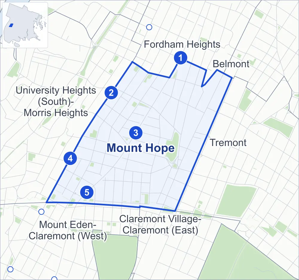
- Mount Hope
- A neighboring area
- Park
- A station in the list
- Another station
Neighborhood areas and streets: NYC Department of City Planning. Parks: NYC Parks. Stations: MTA.
Neighboring areas
- Fordham Heights northeast
- Belmont northeast
- Tremont east
- Claremont Village-Claremont (East) south
- Mount Eden-Claremont (West) southwest
- University Heights (South)-Morris Heights west
Subway stations
- 182-183 Sts lines B D
- Burnside Av lines 4
- Tremont Av lines B D accessible
- 176 St lines 4
- 174-175 Sts lines B D
Getting around
Five subway stations and buses on nine routes stop in or at the edge of Mount Hope.
- 5 subway stations
- 1 of them listed by the MTA as fully accessible
- 8 local bus routes
- 1 express bus route
Local bus routes
- Bx1
- Bx2
- Bx32
- Bx36
- Bx40
- Bx41
- Bx41-SBS
- Bx42
Express bus route
- BxM4
Safety record
Between 2021 and 2025, its corners averaged more police-reported crashes than the average Bronx corner.
- 1,933 police-reported crashes at its corners
- 18.8 a corner, on average
- 8.0 the average Bronx corner
- 3 corners with a clean record
Signal or safety changes on City record, at 36 of its corners
- Leading pedestrian intervals
- 25
- Accessible pedestrian signals
- 24
- Barnes Dance all-way crossings
- 4
- Safety Improvement Projects
- 3
- Turn calming
- 1
Camera tickets
In 2025 its corners had more bus-lane camera tickets than school-zone speed or red-light tickets.
- 0 red-light camera tickets
- 3,762 school-zone speed camera tickets at four corners
- 11,359 bus-lane camera tickets at three corners
- Most speed tickets
- Webster Avenue & East 176th Street, 1,747
- Most bus-lane tickets
- Webster Avenue & Ittner Place, 10,583
People and homes
The 2020 Census counted 49,099 residents in Mount Hope, about 109,100 per square mile.
- 16,783 homes, 2020 Census
- 4,605 homes added since April 2010, net, by City Planning's count
Half of its 865 residential lots hold buildings from 1920 or earlier, and 82% of them date from before 1940, by the City's tax lot records.
Parks and landmarks
- Parkland
- 8.6 acres of NYC Parks property
- The largest pieces
- Richman (Echo) Park (4.4 acres), Mount Hope Playground (0.7 acre) and Cleopatra Playground (0.6 acre)
- Designated landmark
- The Tremont Baptist Church
- Historic district
- Morris Avenue Historic District, wholly or partly within Mount Hope
Streets and trees
- Trees
- 2,261 in NYC Parks' records, most often thornless honeylocust, Japanese zelkova and pin oak
- Street with the most corners
- Anthony Avenue, with 13 of the area's 103
- Height above sea level
- From 30 feet at Webster Avenue & East 175th Street to 118 feet at East 176th Street & Monroe Avenue
- Honorary street names
- 7 at its corners, enacted by local law
Schools
The City lists ten schools in Mount Hope.
- Public schools
- 9
- Charter or private school
- 1
Bike share
By the station list of October 3, 2026, 17 bike-share stations stand in Mount Hope.
- 17 bike-share stations
Public safety
How complaints are countedIn 2025 the NYPD recorded 890 major felonies at places in Mount Hope.
Recorded by the NYPD at places in Mount Hope
- 874 major felonies in 2024
- 3,431 other felonies, misdemeanors and violations in 2025
In 2025, on the streets along the edge of Mount Hope, the NYPD recorded another 192 major felonies. Counting the streets along its edge, in 2025 the NYPD recorded 22.0 major felonies for every thousand residents the 2020 Census counted in Mount Hope.
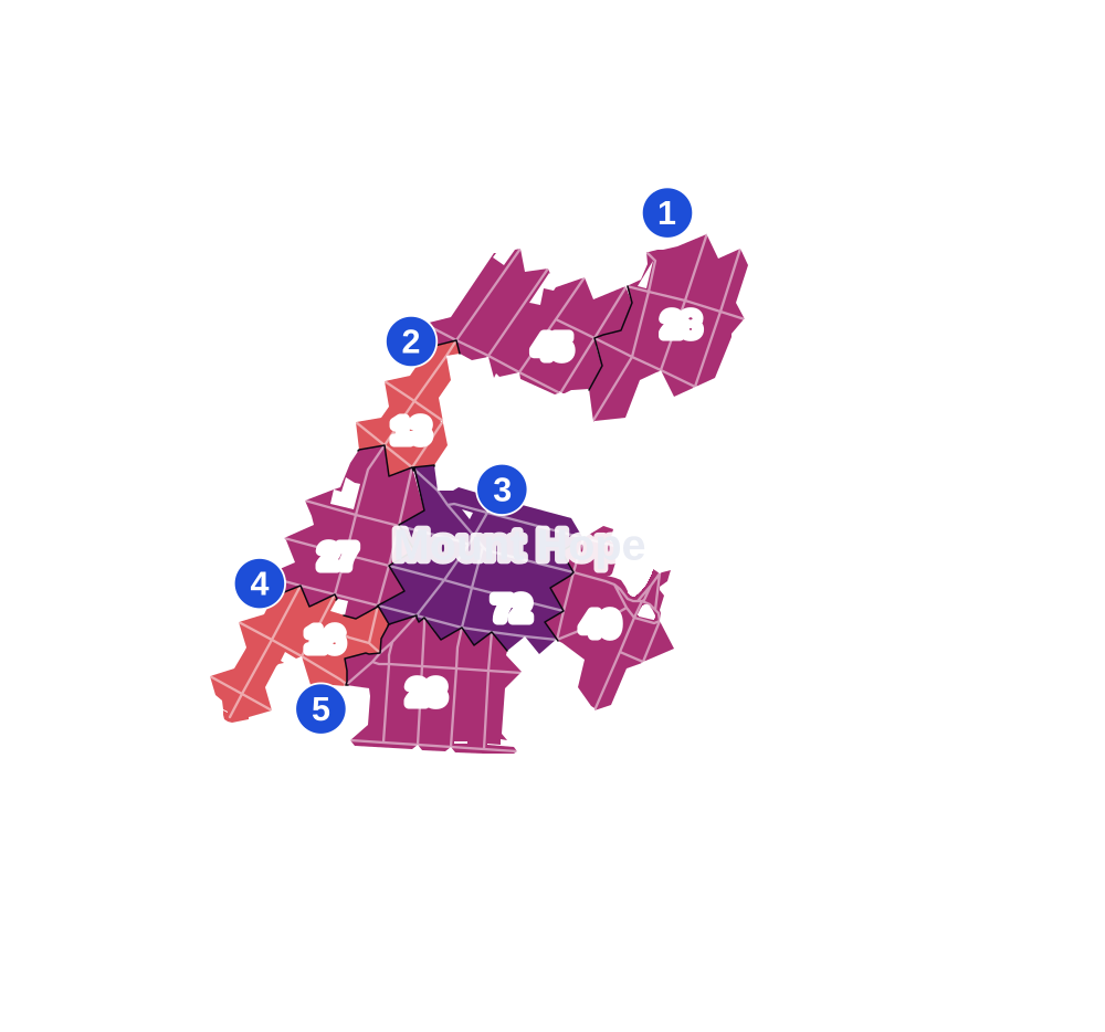
- 5 to 9
- 10 to 19
- 20 to 49
- 50 to 99
- 100 or more
- Not shaded: fewer than 5, held back under the rules in How complaints are counted, parks and public-housing grounds, and land in no patch
- Police precincts
- 46th (most of the area), 48th
From January to June 2026 the NYPD recorded 476 major felonies at places in Mount Hope, against 425 in the same months of 2025.
Sources: the NYPD's Complaint Data Historic, updated April 28, 2026, and Complaint Data Current (Year To Date), updated July 27, 2026, on NYC Open Data. Figures to June 30, 2026.
Street corners
- Anthony Avenue & Bush Street
- Anthony Avenue & East Burnside Avenue
- Anthony Avenue & Echo Place
- Anthony Avenue & Ittner Place
- Anthony Avenue & Mount Hope Place
- Anthony Avenue & Prospect Place
- Clay Avenue & East 175th Street
- Clay Avenue & Prospect Place
- Creston Avenue & Bush Street
- Creston Avenue & East 178th Street
- Creston Avenue & East Burnside Avenue
- Cross Bronx Expressway & Clay Avenue
- Cross Bronx Expressway & Clay Avenue at Ittner Place
- Cross Bronx Expressway & East 174th Street
- Cross Bronx Expressway & Eastburn Avenue
- Cross Bronx Expressway & Grand Concourse
- Cross Bronx Expressway & Jerome Avenue
- Cross Bronx Expressway & Monroe Avenue
- Cross Bronx Expressway & Morris Avenue
- Cross Bronx Expressway & Topping Avenue
- Cross Bronx Expressway & Walton Avenue
- Cross Bronx Expressway & Weeks Avenue
- East 175th Street & Anthony Avenue
- East 175th Street & Carter Avenue
- East 175th Street & Eastburn Avenue
- East 175th Street & Monroe Avenue
- East 175th Street & Topping Avenue
- East 175th Street & Townsend Avenue
- East 175th Street & Weeks Avenue
- East 176th Street & Anthony Avenue
- East 176th Street & Carter Avenue
- East 176th Street & Clay Avenue
- East 176th Street & Monroe Avenue
- East 176th Street & Topping Avenue
- East 176th Street & Townsend Avenue
- East 176th Street & Weeks Avenue
- East 177th Street & Morris Avenue
- East 177th Street & Walton Avenue
- East 178th Street & Anthony Avenue
- East 178th Street & Ryer Avenue
- East 179th Street & Anthony Avenue
- East 179th Street & Creston Avenue
- East 180th Street & Anthony Avenue
- East 180th Street & Creston Avenue
- East 180th Street & Ryer Avenue
- East 180th Street & Tiebout Avenue
- East 180th Street & Valentine Avenue
- East 181st Street & Anthony Avenue
- East 181st Street & Creston Avenue
- East 181st Street & Ryer Avenue
- East 181st Street & Tiebout Avenue
- East Tremont Avenue & Anthony Avenue
- East Tremont Avenue & Carter Avenue
- East Tremont Avenue & Creston Avenue
- East Tremont Avenue & East 176th Street
- East Tremont Avenue & Grand Concourse
- East Tremont Avenue & Monroe Avenue
- East Tremont Avenue & Morris Avenue
- East Tremont Avenue & Valentine Avenue
- East Tremont Avenue & Valentine Avenue at Carter Avenue
- East Tremont Avenue & Walton Avenue
- Grand Concourse & East 176th Street
- Grand Concourse & East Burnside Avenue
- Grand Concourse & Morris Avenue
- Jerome Avenue & Burnside Avenue
- Jerome Avenue & Clifford Place
- Jerome Avenue & Cross Bronx Expressway
- Jerome Avenue & East 175th Street
- Jerome Avenue & East 176th Street
- Jerome Avenue & East 177th Street
- Jerome Avenue & East 179th Street
- Jerome Avenue & West 177th Street
- Jerome Avenue & West Clifford Place
- Monroe Avenue & Mount Hope Place
- Morris Avenue & East 176th Street
- Morris Avenue & East 179th Street
- Morris Avenue & East 181st Street
- Morris Avenue & East Burnside Avenue
- Morris Avenue & Henwood Place
- Morris Avenue & Mount Hope Place
- Ryer Avenue & East Burnside Avenue
- Townsend Avenue & Clifford Place
- Valentine Avenue & East 178th Street
- Valentine Avenue & East 181st Street
- Valentine Avenue & East Burnside Avenue
- Walton Avenue & Clifford Place
- Walton Avenue & East 175th Street
- Walton Avenue & East 176th Street
- Walton Avenue & East 179th Street
- Walton Avenue & East 181st Street
- Walton Avenue & East Burnside Avenue
- Walton Avenue & Henwood Place
- Walton Avenue & Mount Hope Place
- Webster Avenue & Alden Place
- Webster Avenue & East 175th Street
- Webster Avenue & East 176th Street
- Webster Avenue & East 178th Street
- Webster Avenue & East 179th Street
- Webster Avenue & East 180th Street
- Webster Avenue & East 182nd Street
- Webster Avenue & East Tremont Avenue
- Webster Avenue & Ittner Place
- Webster Avenue & Valentine Avenue
How the figures above are measured: Methodology.