Hunts Point
Neighborhood · Bronx
Hunts Point occupies a peninsula in the South Bronx bounded by the Bronx River, the East River and the Bruckner Expressway.
- 1.62 square miles
- 15,131 residents, 2020 Census
- 194 street corners
- 2 subway stations
- 6 bus routes
It is named for Thomas Hunt, one of the first settlers here in the 1670s; Fox, Leggett and Tiffany Streets recall later owners of much of the land; and the area grew quickly after the IRT subway to Manhattan was built in 1904. Today it is home to the city's wholesale food markets, among them the Hunts Point Terminal Market, the country's largest wholesale produce market, and the Fulton Fish Market, which moved here from Lower Manhattan in 2005.
Sources: Hunts Point, Bronx (Wikipedia); Hunts Point Playground (NYC Parks).
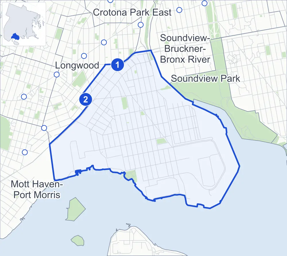
Hunts Point borders five areas, and Bruckner Expressway holds more of its corners than any other street, 19 of 194.
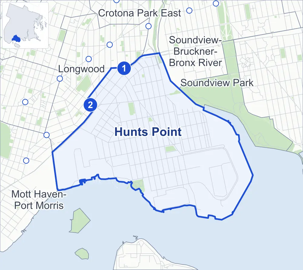
- Hunts Point
- A neighboring area
- Park
- A station in the list
- Another station
Neighborhood areas and streets: NYC Department of City Planning. Parks: NYC Parks. Stations: MTA.
Neighboring areas
- Soundview-Bruckner-Bronx River north
- Crotona Park East north
- Soundview Park northeast
- Mott Haven-Port Morris west
- Longwood northwest
Subway stations
- Hunts Point Av lines 6 accessible
- Longwood Av lines 6
Getting around
Two subway stations and buses on six routes stop in or at the edge of Hunts Point.
- 2 subway stations
- 1 of them listed by the MTA as fully accessible
- 6 local bus routes
Local bus routes
- Bx5
- Bx6
- Bx6-SBS
- Bx19
- Bx46
- T102
Safety record
Between 2021 and 2025, its corners averaged more police-reported crashes than the average Bronx corner.
- 2,277 police-reported crashes at its corners
- 11.7 a corner, on average
- 8.0 the average Bronx corner
- 35 corners with a clean record
Signal or safety changes on City record, at 29 of its corners
- Accessible pedestrian signals
- 19
- Leading pedestrian intervals
- 10
- Safety Improvement Projects
- 4
- Turn calming
- 3
- Barnes Dance all-way crossings
- 1
- Enhanced crossings
- 1
Camera tickets
In 2025 its corners had more school-zone speed camera tickets than red-light or bus-lane tickets.
- 133 red-light camera tickets at one corner
- 14,816 school-zone speed camera tickets at 11 corners
- 0 bus-lane camera tickets
- Most red-light tickets
- Bruckner Boulevard & Longwood Avenue, 133
- Most speed tickets
- Edgewater Road & Seneca Avenue, 9,705
People and homes
The 2020 Census counted 15,131 residents in Hunts Point, about 9,300 per square mile.
- 5,238 homes, 2020 Census
- 974 homes added since April 2010, net, by City Planning's count
Half of its 569 residential lots hold buildings from 1925 or earlier, and 77% of them date from before 1940, by the City's tax lot records.
NYCHA development
One NYCHA development, which NYCHA names by a building's address, lies wholly or partly within Hunts Point.
Parks and landmarks
- Parkland
- 17 acres of NYC Parks property
- The largest pieces
- Barretto Point Park (6.7 acres), Julio Carballo Fields (3.4 acres) and Joseph Rodman Drake Park & Enslaved African Burial Ground (2.5 acres)
- Designated landmarks
- The BankNote; Lafayette Academy, the Sunnyslope and the New York Public Library's Hunts Point Branch
- Historic district
- Manida Street Historic District, wholly or partly within Hunts Point
Streets and trees
- Trees
- 3,555 in NYC Parks' records, most often thornless honeylocust, Japanese zelkova and Callery pear
- Street with the most corners
- Bruckner Expressway, with 19 of the area's 194
- Height above sea level
- From 8 feet at Tiffany Street & Viele Avenue to 85 feet at Lafayette Avenue & Barretto Street
- Honorary street names
- 7 at its corners, enacted by local law
Schools and libraries
The City lists ten schools and one library in Hunts Point.
- Public schools
- 4
- Charter and private schools
- 6
- Library
- Hunts Point Library
Bike share
By the station list of October 3, 2026, seven bike-share stations stand in Hunts Point.
- 7 bike-share stations
Public safety
How complaints are countedIn 2025 the NYPD recorded 518 major felonies at places in Hunts Point.
Recorded by the NYPD at places in Hunts Point
- 548 major felonies in 2024
- 1,634 other felonies, misdemeanors and violations in 2025
In 2025, on the streets along the edge of Hunts Point, the NYPD recorded another 98 major felonies. Counting the streets along its edge, in 2025 the NYPD recorded 40.7 major felonies for every thousand residents the 2020 Census counted in Hunts Point.
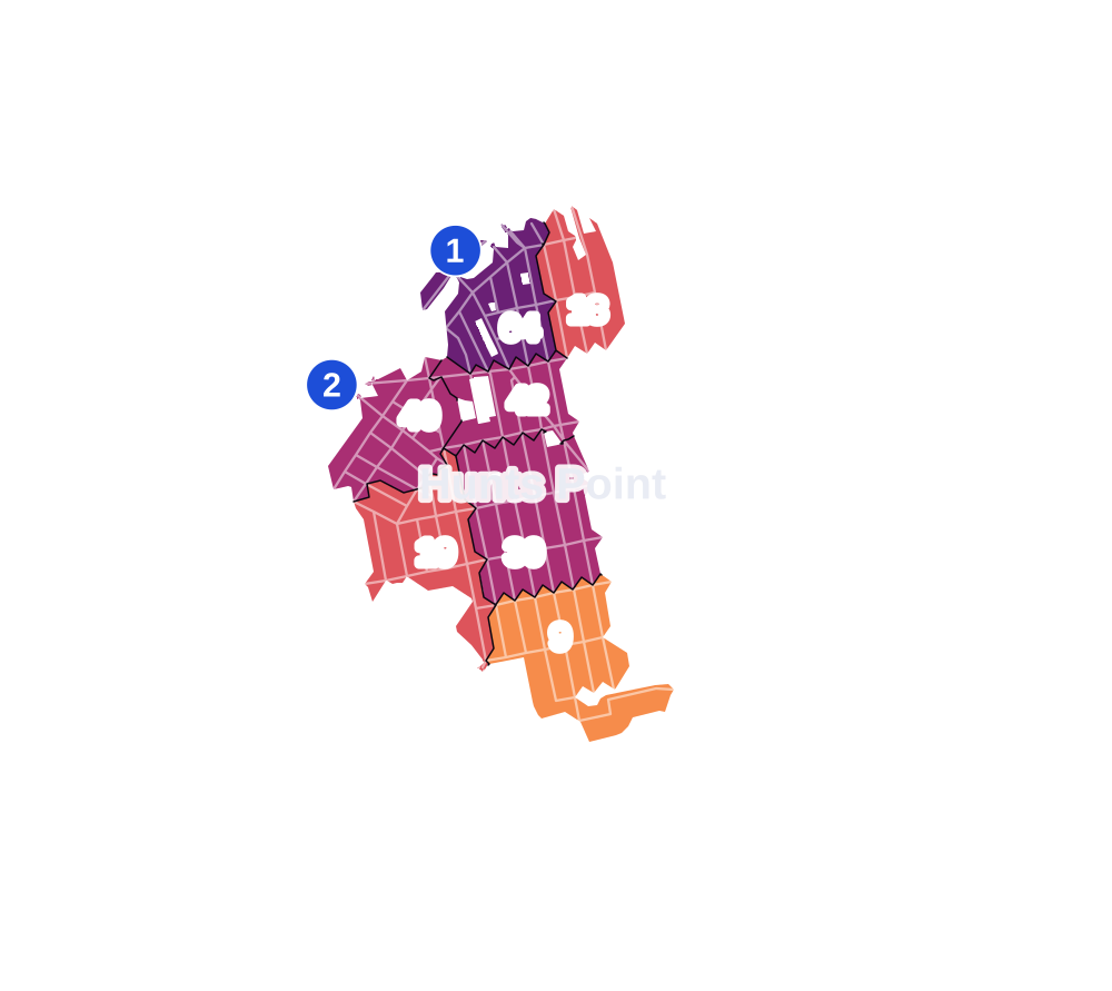
- 5 to 9
- 10 to 19
- 20 to 49
- 50 to 99
- 100 or more
- Not shaded: fewer than 5, held back under the rules in How complaints are counted, parks and public-housing grounds, and land in no patch
- Police precinct
- 41st
From January to June 2026 the NYPD recorded 203 major felonies at places in Hunts Point, against 269 in the same months of 2025.
Sources: the NYPD's Complaint Data Historic, updated April 28, 2026, and Complaint Data Current (Year To Date), updated July 27, 2026, on NYC Open Data. Figures to June 30, 2026.
Street corners
- Avenue A & 1st Street
- Avenue A & 2nd Street
- Avenue A & 3rd Street
- Avenue A & Market Street
- Avenue B & 1st Street
- Avenue B & 2nd Street
- Avenue C & 1st Street
- Avenue C & 2nd Street
- Avenue C & 3rd Street
- Avenue C & Market Street
- Avenue D & 1st Street
- Avenue D & 2nd Street
- Avenue D & 3rd Street
- Avenue D & Market Street
- Avenue E & 1st Street
- Avenue E & 2nd Street
- Avenue E & Avenue F
- Avenue E & Market Street
- Avenue F & 1st Street
- Avenue F & 2nd Street
- Avenue F & Avenue G
- Avenue G & 1st Street
- Avenue G & 2nd Street
- Barretto Street & East Bay Avenue
- Barretto Street & Garrison Avenue
- Barretto Street & Spofford Avenue
- Barretto Street & Viele Avenue
- Barry Street & Burnett Place
- Barry Street & Grinnell Place
- Barry Street & Leggett Avenue
- Barry Street & Worthen Street
- Bruckner Boulevard & Barretto Street
- Bruckner Boulevard & Bruckner Expressway
- Bruckner Boulevard & Bruckner Expressway (Exit 49)
- Bruckner Boulevard & Bruckner Expressway (Exit 50)
- Bruckner Boulevard & Bruckner Expressway at Bruckner Boulevard Bike Path
- Bruckner Boulevard & Bruckner Expressway at Bruckner Boulevard Bike Path (Exit 48)
- Bruckner Boulevard & Bryant Avenue
- Bruckner Boulevard & East 156th Street
- Bruckner Boulevard & Edgewater Road
- Bruckner Boulevard & Hunts Point Avenue
- Bruckner Boulevard & Lafayette Avenue
- Bruckner Boulevard & Leggett Avenue
- Bruckner Boulevard & Longwood Avenue
- Bruckner Boulevard & Tiffany Street
- Bruckner Boulevard & Whitlock Avenue
- Bruckner Boulevard & Whittier Street
- Bruckner Expressway & Barretto Street
- Bruckner Expressway & Bryant Avenue Pedestrian Overpass
- Bruckner Expressway & East 149th Street
- Bruckner Expressway & Hunts Point Avenue
- Bruckner Expressway & Lafayette Avenue
- Bruckner Expressway & Leggett Avenue
- Bruckner Expressway & Longwood Avenue
- Bruckner Expressway & Sheridan Boulevard (east)
- Bruckner Expressway & Sheridan Boulevard (Exit 49)
- Bruckner Expressway & Sheridan Boulevard (west)
- Bruckner Expressway & Sheridan Boulevard at Bruckner Boulevard
- Bruckner Expressway & Tiffany Street
- Bryant Avenue & East Bay Avenue
- Bryant Avenue & Garrison Avenue
- Bryant Avenue & Hunts Point Avenue
- Bryant Avenue & Oak Point Avenue
- Bryant Avenue & Randall Avenue
- Bryant Avenue & Ryawa Avenue
- Bryant Avenue & Seneca Avenue
- Bryant Avenue & Spofford Avenue
- Bryant Avenue & Viele Avenue
- Casanova Street & East Bay Avenue
- Casanova Street & Spofford Avenue
- Coster Street & East Bay Avenue
- Coster Street & Spofford Avenue
- Coster Street & Viele Avenue
- Drake Street & East Bay Avenue
- Drake Street & Ryawa Avenue
- Drake Street & Spofford Avenue
- East 149th Street & Oak Point Avenue
- East 156th Street & Barry Street
- East 156th Street & Garrison Avenue
- East 156th Street & Truxton Street
- East 156th Street & Worthen Street
- Edgewater Road & Avenue A
- Edgewater Road & Seneca Avenue
- Edgewater Road & Sheridan Boulevard
- Faile Street & East Bay Avenue
- Faile Street & Garrison Avenue
- Faile Street & Gilbert Place
- Faile Street & Hunts Point Avenue
- Faile Street & Ryawa Avenue
- Faile Street & Seneca Avenue
- Faile Street & Spofford Avenue
- Faile Street & Viele Avenue
- Food Center Drive & Farragut Street
- Food Center Drive & Halleck Street at East Bay Avenue
- Food Center Drive & Halleck Street at Ryawa Avenue
- Food Center Drive & Market Street
- Fox Street & Intervale Avenue
- Fox Street & Longwood Avenue
- Garrison Avenue & Burnett Place
- Garrison Avenue & Grinnell Place
- Garrison Avenue & Irvine Street
- Garrison Avenue & Leggett Avenue
- Garrison Avenue & Longwood Avenue
- Garrison Avenue & Worthen Street
- Halleck Street & Spofford Avenue
- Halleck Street & Viele Avenue
- Hunts Point Avenue & Coster Street
- Hunts Point Avenue & Drake Park South
- Hunts Point Avenue & East Bay Avenue
- Hunts Point Avenue & Garrison Avenue
- Hunts Point Avenue & Gilbert Place
- Hunts Point Avenue & Seneca Avenue
- Hunts Point Avenue & Spofford Avenue
- Hunts Point Avenue & Whittier Street
- Lafayette Avenue & Barretto Street
- Lafayette Avenue & Barry Street
- Lafayette Avenue & Bryant Avenue
- Lafayette Avenue & Edgewater Road
- Lafayette Avenue & Faile Street
- Lafayette Avenue & Garrison Avenue
- Lafayette Avenue & Hunts Point Avenue
- Lafayette Avenue & Longfellow Avenue
- Lafayette Avenue & Manida Street
- Lafayette Avenue & Tiffany Street
- Lafayette Avenue & Whittier Street
- Leggett Avenue & Bruckner Expressway
- Leggett Avenue & Dupont Street
- Longfellow Avenue & Drake Park South
- Longfellow Avenue & East Bay Avenue
- Longfellow Avenue & Garrison Avenue
- Longfellow Avenue & Hunts Point Avenue
- Longfellow Avenue & Oak Point Avenue
- Longfellow Avenue & Seneca Avenue
- Longfellow Avenue & Spofford Avenue
- Longfellow Avenue & Viele Avenue
- Longwood Avenue & Barry Street
- Longwood Avenue & Spofford Avenue
- Longwood Avenue & Truxton Street
- Manida Street & East Bay Avenue
- Manida Street & Garrison Avenue
- Manida Street & Spofford Avenue
- Manida Street & Viele Avenue
- Market Street & Avenue B
- Market Street & Avenue F
- Oak Point Avenue & Barretto Street
- Oak Point Avenue & Barry Street
- Oak Point Avenue & Casanova Street
- Oak Point Avenue & Coster Street
- Oak Point Avenue & Craven Street
- Oak Point Avenue & Faile Street
- Oak Point Avenue & Halleck Street
- Oak Point Avenue & Hunts Point Avenue
- Oak Point Avenue & Hunts Point Avenue at Drake Street
- Oak Point Avenue & Manida Street
- Oak Point Avenue & Whittier Street
- Oak Point Avenue & Worthen Street
- Randall Avenue & Barretto Street
- Randall Avenue & Casanova Street
- Randall Avenue & Coster Street
- Randall Avenue & Craven Street
- Randall Avenue & Drake Street
- Randall Avenue & Faile Street
- Randall Avenue & Halleck Street
- Randall Avenue & Hunts Point Avenue
- Randall Avenue & Leggett Avenue
- Randall Avenue & Longfellow Avenue
- Randall Avenue & Manida Street
- Randall Avenue & Tiffany Street
- Randall Avenue & Whittier Street
- Randall Avenue & Worthen Street
- Seneca Avenue & Irvine Street
- Sheridan Boulevard & Bruckner Expressway
- Southern Boulevard & Barretto Street
- Southern Boulevard & Intervale Avenue
- Southern Boulevard & Longwood Avenue
- Southern Boulevard & Tiffany Street
- Tiffany Street & Barry Street
- Tiffany Street & Burnett Place
- Tiffany Street & East Bay Avenue
- Tiffany Street & Garrison Avenue
- Tiffany Street & Longwood Avenue
- Tiffany Street & Oak Point Avenue
- Tiffany Street & Spofford Avenue
- Tiffany Street & Viele Avenue
- Truxton Street & Grinnell Place
- Viele Avenue & Casanova Street
- Viele Avenue & Drake Street
- Whittier Street & East Bay Avenue
- Whittier Street & Garrison Avenue
- Whittier Street & Ryawa Avenue
- Whittier Street & Seneca Avenue
- Whittier Street & Spofford Avenue
- Whittier Street & Viele Avenue
- Worthen Street & Truxton Street
How the figures above are measured: Methodology.