Mott Haven-Port Morris
Neighborhood · Bronx
Mott Haven-Port Morris runs from the Harlem River and the Bronx Kill north to about East 149th Street, with the Port Morris waterfront along the East River.
- 1.47 square miles
- 57,718 residents, 2020 Census
- 266 street corners
- 8 subway stations
- 14 bus routes
Mott Haven is named for Jordan L. Mott, inventor of a coal-burning stove, whose ironworks stood on the Harlem River at 134th Street, and Port Morris takes its name from a deep-water port that Gouverneur Morris Jr. established in 1842 and was once known for its piano factories. The row houses of the Mott Haven Historic District along Alexander Avenue were designated in 1969, and St. Mary's Park opened the borough's first playground in 1914.
Sources: Mott Haven Historic District, Borough of The Bronx (LP-0451, July 29, 1969) (NYC Landmarks Preservation Commission); Mott Haven, Bronx (Wikipedia); Port Morris, Bronx (Wikipedia); St. Mary's Park (NYC Parks).
Mott Haven-Port Morris borders five areas, and Bruckner Boulevard holds more of its corners than any other street, 26 of 266.
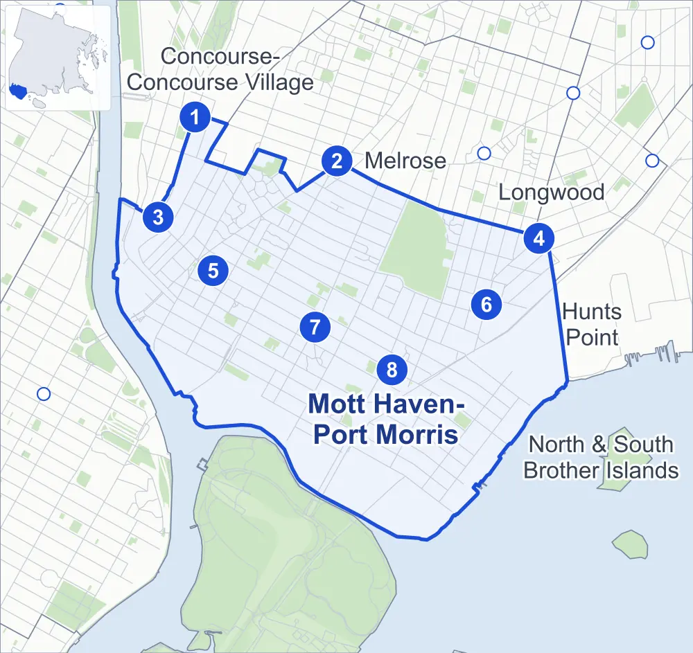
- Mott Haven-Port Morris
- A neighboring area
- Park
- A station in the list
- Another station
Neighborhood areas and streets: NYC Department of City Planning. Parks: NYC Parks. Stations: MTA.
Neighboring areas
- Melrose north
- Hunts Point east
- Longwood east
- North & South Brother Islands southeast
- Concourse-Concourse Village northwest
Subway stations
- 149 St-Hostos lines 2 4 5
- 3 Av-149 St lines 2 5 accessible
- 138 St-Grand Concourse lines 4 5
- E 149 St lines 6 accessible
- 3 Av-138 St lines 6
- E 143 St-St Mary's St lines 6
- Brook Av lines 6
- Cypress Av lines 6
Getting around
Eight subway stations and buses on 14 routes stop in or at the edge of Mott Haven-Port Morris.
- 8 subway stations
- 2 of them listed by the MTA as fully accessible
- 14 local bus routes
Local bus routes
- Bx1
- Bx2
- Bx4
- Bx15
- Bx17
- Bx19
- Bx21
- Bx32
- Bx33
- Bx41
- Bx41-SBS
- BX92
- M125
- T102
Safety record
Between 2021 and 2025, its corners averaged more police-reported crashes than the average Bronx corner.
- 3,018 police-reported crashes at its corners
- 11.3 a corner, on average
- 8.0 the average Bronx corner
- 25 corners with a clean record
Signal or safety changes on City record, at 59 of its corners
- Accessible pedestrian signals
- 45
- Leading pedestrian intervals
- 40
- Turn calming
- 11
- Barnes Dance all-way crossings
- 9
- Safety Improvement Projects
- 3
Camera tickets
In 2025 its corners had more school-zone speed camera tickets than red-light or bus-lane tickets.
- 20,934 red-light camera tickets at five corners
- 47,088 school-zone speed camera tickets at nine corners
- 3,794 bus-lane camera tickets at one corner
- Most red-light tickets
- East 135th Street & Alexander Avenue, 9,698
- Most speed tickets
- Bruckner Boulevard & East 149th Street, 20,536
- Most bus-lane tickets
- East 149th Street & Bergen Avenue, 3,794
People and homes
The 2020 Census counted 57,718 residents in Mott Haven-Port Morris, about 39,300 per square mile.
- 21,159 homes, 2020 Census
- 7,785 homes added since April 2010, net, by City Planning's count
Half of its 1,457 residential lots hold buildings from 1931 or earlier, and 58% of them date from before 1940, by the City's tax lot records.
NYCHA developments
NYCHA's Mill Brook, Mill Brook Extension, Mitchel, Mott Haven and Patterson developments lie wholly or partly within Mott Haven-Port Morris.
Parks and landmarks
- Parkland
- 52.2 acres of NYC Parks property
- The largest pieces
- St. Mary's Park (35.2 acres), Patterson Playground (2.4 acres) and Playground One Thirty Four CXXXIV (2 acres)
- Designated landmarks
- The Estey Piano Company Factory; the Samuel Gompers Industrial High School; the Bronx Grit Chamber; and the Fire House, Hook and Ladder 17/Engine Company 60, among others
- Historic districts
- Bertine Block, Mott Haven East and Mott Haven, wholly or partly within Mott Haven-Port Morris
Streets and trees
- Trees
- 4,696 in NYC Parks' records, most often London planetree, thornless honeylocust and pin oak
- Street with the most corners
- Bruckner Boulevard, with 26 of the area's 266
- Height above sea level
- From 6 feet at East 132nd Street & Lincoln Avenue to 64 feet at East 139th Street & Cypress Avenue
- Honorary street names
- 11 at its corners, enacted by local law
Schools and libraries
The City lists 44 schools and one library in Mott Haven-Port Morris.
- Public schools
- 19
- Charter and private schools
- 25
- Library
- Mott Haven Library
Bike share and public art
By the station list of October 3, 2026, 32 bike-share stations stand in Mott Haven-Port Morris. The City's public art inventory lists three works in the area: Spanish War Memorial (1919), Bronx Local Board #2 World War Memorial (1921) and Para Roberto (2019).
- 32 bike-share stations
- 3 works of public art
Public safety
How complaints are countedIn 2025 the NYPD recorded 1,613 major felonies at places in Mott Haven-Port Morris.
Recorded by the NYPD at places in Mott Haven-Port Morris
- 1,428 major felonies in 2024
- 5,292 other felonies, misdemeanors and violations in 2025
In 2025, on the streets along the edge of Mott Haven-Port Morris, the NYPD recorded another 363 major felonies. Counting the streets along its edge, in 2025 the NYPD recorded 34.2 major felonies for every thousand residents the 2020 Census counted in Mott Haven-Port Morris.
- Police precinct
- 40th
From January to June 2026 the NYPD recorded 767 major felonies at places in Mott Haven-Port Morris, against 802 in the same months of 2025.
Sources: the NYPD's Complaint Data Historic, updated April 28, 2026, and Complaint Data Current (Year To Date), updated July 27, 2026, on NYC Open Data. Figures to June 30, 2026.
Street corners
- 3rd Avenue & 3rd Avenue Bridge Bike Path
- 3rd Avenue & East 135th Street
- 3rd Avenue & East 136th Street
- 3rd Avenue & East 137th Street
- 3rd Avenue & East 139th Street
- 3rd Avenue & East 140th Street
- 3rd Avenue & East 141st Street
- 3rd Avenue & East 142nd Street
- 3rd Avenue & East 143rd Street
- 3rd Avenue & East 144th Street
- 3rd Avenue & East 145th Street
- 3rd Avenue & Morris Avenue at East 138th Street
- 3rd Avenue & Morris Avenue at East 138th Street (Lincoln Avenue)
- 3rd Avenue Bridge & 3rd Avenue
- 3rd Avenue Bridge & 3rd Avenue at East 134th Street
- 3rd Avenue Bridge & 3rd Avenue at East 135th Street
- 3rd Avenue Bridge & Bruckner Boulevard
- 3rd Avenue Bridge & Bruckner Boulevard at 3rd Avenue
- 3rd Avenue Bridge & Bruckner Boulevard at 3rd Avenue Bridge Bike Path
- 3rd Avenue Bridge & Bruckner Boulevard at Lincoln Avenue
- Alexander Avenue & East 142nd Street
- Alexander Avenue & Major Deegan Expressway
- Beekman Avenue & Beech Terrace
- Beekman Avenue & Oak Terrace
- Brook Avenue & East 132nd Street
- Brook Avenue & East 134th Street
- Brook Avenue & East 135th Street
- Brook Avenue & East 136th Street
- Brook Avenue & East 137th Street
- Brook Avenue & East 138th Street
- Brook Avenue & East 139th Street
- Brook Avenue & East 140th Street
- Brook Avenue & East 141st Street
- Brook Avenue & East 142nd Street
- Brook Avenue & East 143rd Street
- Brook Avenue & East 144th Street
- Brook Avenue & East 145th Street
- Brook Avenue & East 146th Street
- Brook Avenue & East 147th Street
- Brook Avenue & East 148th Street
- Bruckner Boulevard & Alexander Avenue
- Bruckner Boulevard & Brook Avenue
- Bruckner Boulevard & Brown Place
- Bruckner Boulevard & Bruckner Expressway
- Bruckner Boulevard & Bruckner Expressway (Exit 48)
- Bruckner Boulevard & East 133rd Street
- Bruckner Boulevard & East 134th Street
- Bruckner Boulevard & East 135th Street
- Bruckner Boulevard & East 135th Street at Cypress Avenue
- Bruckner Boulevard & East 138th Street
- Bruckner Boulevard & East 140th Street
- Bruckner Boulevard & East 141st Street
- Bruckner Boulevard & East 149th Street
- Bruckner Boulevard & RFK Bridge Bronx
- Bruckner Boulevard & Southern Boulevard
- Bruckner Boulevard & St Anns Avenue
- Bruckner Boulevard & St Anns Place
- Bruckner Boulevard & Willis Avenue
- Bruckner Boulevard & Willis Avenue at Willis Avenue Bridge Bike Path
- Bruckner Boulevard & Willis Avenue Bridge
- Bruckner Boulevard & Willis Avenue Bridge Bike Path
- Bruckner Expressway & Bruckner Boulevard
- Bruckner Expressway & East 140th Street
- Bruckner Expressway & East 141st Street
- College Avenue & East 145th Street
- Concord Avenue & East 142nd Street
- Concord Avenue & St Marys Street
- Cypress Avenue & East 133rd Street
- Cypress Avenue & East 133rd Street at RFK Bridge Bronx Pedestrian and Bike Path
- Cypress Avenue & St Marys Street
- East 132nd Street & Alexander Avenue
- East 132nd Street & Cypress Avenue
- East 132nd Street & Cypress Avenue at RFK Bridge Bronx Pedestrian and Bike Path
- East 132nd Street & Lincoln Avenue
- East 132nd Street & Locust Avenue
- East 132nd Street & RFK Bridge Bronx Pedestrian and Bike Path
- East 132nd Street & Walnut Avenue
- East 132nd Street & Willis Avenue
- East 132nd Street & Willow Avenue
- East 133rd Street & Cypress Place
- East 133rd Street & Locust Avenue
- East 133rd Street & Walnut Avenue
- East 133rd Street & Willow Avenue
- East 134th Street & 3rd Avenue Bridge Bike Path
- East 134th Street & Alexander Avenue
- East 134th Street & Brown Place
- East 134th Street & Lincoln Avenue
- East 134th Street & Locust Avenue
- East 134th Street & Major Deegan Expressway
- East 134th Street & RFK Bridge Bronx
- East 134th Street & Walnut Avenue
- East 134th Street & Willow Avenue
- East 135th Street & 3rd Avenue Bridge Bike Path
- East 135th Street & Alexander Avenue
- East 135th Street & Brown Place
- East 135th Street & Canal Place
- East 135th Street & Canal Street West
- East 135th Street & Lincoln Avenue
- East 135th Street & Locust Avenue
- East 135th Street & Major Deegan Expressway
- East 135th Street & Major Deegan Expressway (Exit 2)
- East 135th Street & Rider Avenue
- East 135th Street & Walnut Avenue
- East 135th Street & Willow Avenue
- East 136th Street & Brown Place
- East 136th Street & Cypress Avenue
- East 136th Street & Lincoln Avenue
- East 136th Street & Locust Avenue
- East 136th Street & Rider Avenue
- East 136th Street & Walnut Avenue
- East 136th Street & Willow Avenue
- East 137th Street & Alexander Avenue
- East 137th Street & Brown Place
- East 137th Street & Cypress Avenue
- East 137th Street & Lincoln Avenue
- East 137th Street & Rider Avenue
- East 137th Street & Walnut Avenue
- East 137th Street & Willis Avenue
- East 137th Street & Willow Avenue
- East 138th Street & Alexander Avenue
- East 138th Street & Brown Place
- East 138th Street & Bruckner Expressway
- East 138th Street & Canal Place
- East 138th Street & Canal Street West
- East 138th Street & Cypress Avenue
- East 138th Street & Jackson Avenue
- East 138th Street & Locust Avenue
- East 138th Street & Major Deegan Expressway
- East 138th Street & Rider Avenue
- East 138th Street & St Anns Avenue
- East 138th Street & Walnut Avenue
- East 138th Street & Willis Avenue
- East 138th Street & Willow Avenue
- East 139th Street & Alexander Avenue
- East 139th Street & Cypress Avenue
- East 139th Street & Locust Avenue
- East 139th Street & Rider Avenue
- East 139th Street & Walnut Avenue
- East 139th Street & Willis Avenue
- East 140th Street & Alexander Avenue
- East 140th Street & Bruckner Boulevard Bike Path
- East 140th Street & Canal Place
- East 140th Street & Cypress Avenue
- East 140th Street & Jackson Avenue
- East 140th Street & Locust Avenue
- East 140th Street & Rider Avenue
- East 140th Street & St Anns Avenue
- East 140th Street & Walnut Avenue
- East 140th Street & Willis Avenue
- East 141st Street & Alexander Avenue
- East 141st Street & Beekman Avenue
- East 141st Street & Canal Place
- East 141st Street & Concord Avenue
- East 141st Street & Crimmins Avenue
- East 141st Street & Cypress Avenue
- East 141st Street & Jackson Avenue
- East 141st Street & Locust Avenue
- East 141st Street & Powers Avenue
- East 141st Street & Rider Avenue
- East 141st Street & Wales Avenue
- East 141st Street & Walnut Avenue
- East 141st Street & Willis Avenue
- East 142nd Street & Powers Avenue
- East 142nd Street & Rider Avenue
- East 143rd Street & Alexander Avenue
- East 143rd Street & Willis Avenue
- East 144th Street & Anthony J Griffin Place
- East 144th Street & Austin Place
- East 144th Street & Canal Place
- East 144th Street & Concord Avenue
- East 144th Street & Rider Avenue
- East 144th Street & Timpson Place
- East 144th Street & Wales Avenue
- East 144th Street & Willis Avenue
- East 145th Street & Concord Avenue
- East 145th Street & Timpson Place
- East 145th Street & Wales Avenue
- East 146th Street & Willis Avenue
- East 147th Street & Austin Place
- East 147th Street & Bergen Avenue
- East 147th Street & Concord Avenue
- East 147th Street & Timpson Place
- East 147th Street & Trinity Avenue
- East 147th Street & Wales Avenue
- East 148th Street & Bergen Avenue
- East 149th Street & Austin Place
- East 149th Street & Bergen Avenue
- East 149th Street & Concord Avenue
- East 149th Street & Eagle Avenue
- East 149th Street & Jackson Avenue
- East 149th Street & St Anns Avenue
- East 149th Street & Tinton Avenue
- East 149th Street & Union Avenue
- Exterior Street & East 135th Street
- Exterior Street & East 138th Street
- Exterior Street & Madison Avenue Bridge Pedestrian & Bike Path
- Grand Concourse & East 138th Street
- Grand Concourse & East 140th Street
- Grand Concourse & Major Deegan Expressway
- Grand Concourse & Major Deegan Expressway (Exit 3)
- Jackson Avenue & East 139th Street
- Jackson Avenue & East 142nd Street
- Jackson Avenue & East 144th Street
- Jackson Avenue & East 145th Street
- Jackson Avenue & East 147th Street
- Jackson Avenue & St Marys Street
- Madison Avenue Bridge & East 138th Street
- Madison Avenue Bridge & Exterior Street
- Major Deegan Expressway & 3rd Avenue
- Major Deegan Expressway & Alexander Avenue
- Major Deegan Expressway & Brook Avenue
- Major Deegan Expressway & Bruckner Expressway
- Major Deegan Expressway & Bruckner Expressway at RFK Bridge Bronx
- Major Deegan Expressway & East 138th Street
- Major Deegan Expressway & Lincoln Avenue
- Major Deegan Expressway & Willis Avenue Bridge
- Major Deegan Expressway & Willis Avenue Bridge Bike Path
- Major Deegan Expressway & Willis Avenue Bridge Bike Path (Willis Avenue Bridge)
- Morris Avenue & East 139th Street
- Morris Avenue & East 140th Street
- Morris Avenue & East 142nd Street
- Morris Avenue & East 143rd Street
- Morris Avenue & East 148th Street
- Park Avenue & East 135th Street
- Park Avenue & East 138th Street
- Park Avenue & East 140th Street
- Park Avenue & East 141st Street
- Park Avenue & East 144th Street
- Park Avenue & East 146th Street
- Southern Boulevard & East 142nd Street
- Southern Boulevard & East 144th Street
- Southern Boulevard & East 145th Street
- Southern Boulevard & East 147th Street
- Southern Boulevard & Prospect Avenue
- Southern Boulevard & St Marys Street
- Southern Boulevard & Tinton Avenue
- Southern Boulevard & Union Avenue
- St Anns Avenue & East 132nd Street
- St Anns Avenue & East 134th Street
- St Anns Avenue & East 135th Street
- St Anns Avenue & East 137th Street
- St Anns Avenue & East 139th Street
- St Anns Avenue & East 141st Street
- St Anns Avenue & East 142nd Street
- St Anns Avenue & East 143rd Street
- St Anns Avenue & East 144th Street
- St Anns Avenue & East 145th Street
- St Anns Avenue & East 146th Street
- St Anns Avenue & East 147th Street
- St Anns Avenue & East 148th Street
- St Anns Avenue & Fresh Direct Drive
- St Marys Street & Beekman Avenue
- St Marys Street & Crimmins Avenue
- St Marys Street & Powers Avenue
- Tinton Avenue & East 145th Street
- Tinton Avenue & East 147th Street
- Triborough Bridge & East 132nd Street
- Wales Avenue & East 142nd Street
- Wales Avenue & St Marys Street
- Willis Avenue & East 136th Street
- Willis Avenue & East 142nd Street
- Willis Avenue & East 145th Street
- Willis Avenue & East 147th Street
- Willis Avenue & East 148th Street
- Willis Avenue Bridge & East 135th Street
- Willis Avenue Bridge & Major Deegan Expressway
How the figures above are measured: Methodology.