Melrose
Neighborhood · Bronx
Melrose lies in the South Bronx between Park Avenue and St. Ann's Avenue, north of East 149th Street, and includes the Hub, where East 149th Street meets Third, Willis, Melrose and Westchester Avenues.
- 0.62 square miles
- 42,651 residents, 2020 Census
- 137 street corners
- 4 subway stations
- 13 bus routes
Named after Melrose Abbey, it began in the 19th century as one of the villages that grew up around rural railroad stations, and its early population was largely German American. The Third Avenue elevated line, an early draw for residents, served the neighborhood until it was taken down in 1973, and the Hub remains a major retail district.
Sources: Melrose, Bronx (Wikipedia); The Bronx (The Bronx County Historical Society).
Melrose borders four areas, and 3rd Avenue holds more of its corners than any other street, 18 of 137.
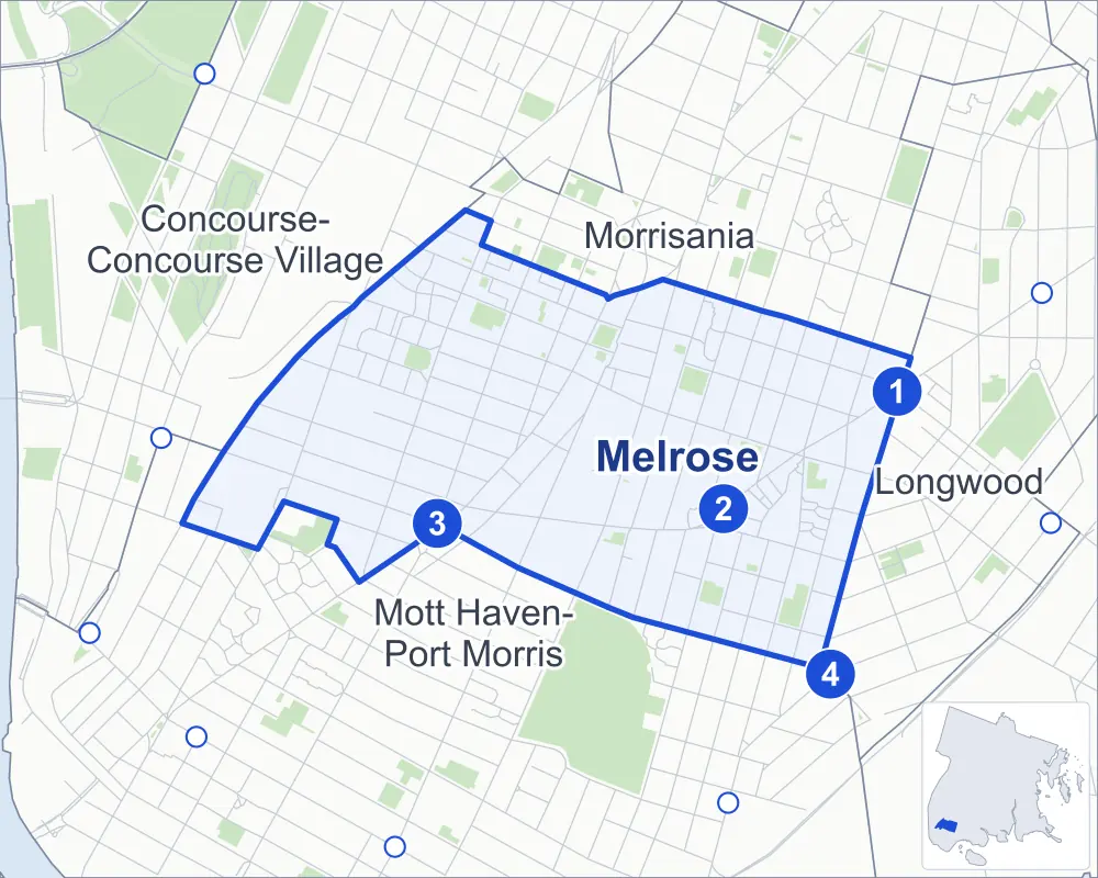
- Melrose
- A neighboring area
- Park
- A station in the list
- Another station
Neighborhood areas and streets: NYC Department of City Planning. Parks: NYC Parks. Stations: MTA.
Neighboring areas
- Morrisania northeast
- Longwood east
- Mott Haven-Port Morris southwest
- Concourse-Concourse Village northwest
Subway stations
- Prospect Av lines 2 5
- Jackson Av lines 2 5
- 3 Av-149 St lines 2 5 accessible
- E 149 St lines 6 accessible
Getting around
Four subway stations and buses on 13 routes stop in or at the edge of Melrose.
- 4 subway stations
- 2 of them listed by the MTA as fully accessible
- 13 local bus routes
Local bus routes
- Bx2
- Bx4
- Bx15
- Bx17
- Bx19
- Bx21
- Bx32
- Bx41
- Bx41-SBS
- Bx46
- BX92
- M125
- T102
Safety record
Between 2021 and 2025, its corners averaged more police-reported crashes than the average Bronx corner.
- 1,508 police-reported crashes at its corners
- 11.0 a corner, on average
- 8.0 the average Bronx corner
- 5 corners with a clean record
Signal or safety changes on City record, at 43 of its corners
- Leading pedestrian intervals
- 30
- Accessible pedestrian signals
- 22
- Turn calming
- 10
- Barnes Dance all-way crossings
- 5
- Safety Improvement Projects
- 4
Camera tickets
In 2025 its corners had more school-zone speed camera tickets than bus-lane or red-light tickets.
- 0 red-light camera tickets
- 4,014 school-zone speed camera tickets at nine corners
- 1,836 bus-lane camera tickets at one corner
- Most speed tickets
- East 149th Street & Courtlandt Avenue, 1,509
- Most bus-lane tickets
- East 149th Street & Courtlandt Avenue, 1,836
People and homes
The 2020 Census counted 42,651 residents in Melrose, about 68,800 per square mile.
- 15,481 homes, 2020 Census
- 3,561 homes added since April 2010, net, by City Planning's count
Half of its 1,216 residential lots hold buildings from 1992 or earlier, and 41% of them date from before 1940, by the City's tax lot records.
NYCHA developments
NYCHA's Adams, Jackson, Melrose and Saint Mary's Park developments lie wholly or partly within Melrose.
Parks and landmarks
- Parkland
- 10.2 acres of NYC Parks property
- The largest pieces
- Fountain Of Youth Playground (1.2 acres), Grove Hill Playground (1.2 acres) and Melrose Playground (1.1 acres)
- Designated landmarks
- The Engine Company/Squad 41; the New York Public Library's Woodstock Branch; and the Firehouses, Engine Company 73 and Hook & Ladder Company 42
Streets and trees
- Trees
- 2,718 in NYC Parks' records, most often thornless honeylocust, Japanese zelkova and London planetree
- Street with the most corners
- 3rd Avenue, with 18 of the area's 137
- Height above sea level
- From 13 feet at Westchester Avenue & Brook Avenue to 71 feet at East 158th Street & Cauldwell Avenue
- Honorary street names
- 28 at its corners, enacted by local law
Schools and libraries
The City lists 33 schools and one library in Melrose.
- Public schools
- 20
- Charter and private schools
- 13
- Library
- Woodstock Library
Bike share and public art
By the station list of October 3, 2026, 20 bike-share stations stand in Melrose. The City's public art inventory lists one work in the area: Fire hat (1994).
- 20 bike-share stations
- 1 work of public art
Public safety
How complaints are countedIn 2025 the NYPD recorded 1,070 major felonies at places in Melrose.
Recorded by the NYPD at places in Melrose
- 1,154 major felonies in 2024
- 3,656 other felonies, misdemeanors and violations in 2025
In 2025, on the streets along the edge of Melrose, the NYPD recorded another 411 major felonies. Counting the streets along its edge, in 2025 the NYPD recorded 34.7 major felonies for every thousand residents the 2020 Census counted in Melrose.
- Police precinct
- 40th
From January to June 2026 the NYPD recorded 468 major felonies at places in Melrose, against 524 in the same months of 2025.
Sources: the NYPD's Complaint Data Historic, updated April 28, 2026, and Complaint Data Current (Year To Date), updated July 27, 2026, on NYC Open Data. Figures to June 30, 2026.
Street corners
- 3rd Avenue & East 146th Street
- 3rd Avenue & East 146th Street at Courtlandt Avenue
- 3rd Avenue & East 147th Street
- 3rd Avenue & East 148th Street
- 3rd Avenue & East 149th Street
- 3rd Avenue & East 151st Street
- 3rd Avenue & East 152nd Street
- 3rd Avenue & East 153rd Street
- 3rd Avenue & East 154th Street
- 3rd Avenue & East 155th Street
- 3rd Avenue & East 156th Street
- 3rd Avenue & East 157th Street
- 3rd Avenue & East 158th Street
- 3rd Avenue & Elton Avenue
- 3rd Avenue & St Anns Avenue
- 3rd Avenue & Washington Avenue at East 159th Street
- 3rd Avenue & Westchester Avenue
- 3rd Avenue & Willis Avenue
- Brook Avenue & Bergen Avenue
- Brook Avenue & East 153rd Street
- Brook Avenue & East 156th Street
- Brook Avenue & East 157th Street
- Brook Avenue & East 158th Street
- Brook Avenue & East 159th Street
- Cauldwell Avenue & East 160th Street
- College Avenue & East 148th Street
- Courtlandt Avenue & East 148th Street
- Courtlandt Avenue & East 152nd Street
- Courtlandt Avenue & East 154th Street
- Courtlandt Avenue & East 155th Street
- Eagle Avenue & East 159th Street
- Eagle Avenue & Terrace Place
- East 143rd Street & East 144th Street
- East 146th Street & College Avenue
- East 149th Street & Brook Avenue
- East 149th Street & Cauldwell Avenue
- East 149th Street & Courtlandt Avenue
- East 149th Street & Melrose Avenue
- East 149th Street & Trinity Avenue
- East 149th Street & Wales Avenue
- East 150th Street & Concord Avenue
- East 150th Street & Courtlandt Avenue
- East 150th Street & Melrose Avenue
- East 150th Street & Wales Avenue
- East 151st Street & Concord Avenue
- East 151st Street & Courtlandt Avenue
- East 151st Street & Melrose Avenue
- East 151st Street & Wales Avenue
- East 152nd Street & Bergen Avenue
- East 152nd Street & Concord Avenue
- East 153rd Street & Bergen Avenue
- East 153rd Street & Courtlandt Avenue
- East 153rd Street & Elton Avenue
- East 153rd Street & Melrose Avenue
- East 156th Street & Cauldwell Avenue
- East 156th Street & Courtlandt Avenue
- East 156th Street & Eagle Avenue
- East 156th Street & Elton Avenue
- East 156th Street & Forest Avenue
- East 156th Street & Hegney Place
- East 156th Street & Jackson Avenue
- East 156th Street & Melrose Avenue
- East 156th Street & Tinton Avenue
- East 156th Street & Trinity Avenue
- East 157th Street & Courtlandt Avenue
- East 157th Street & Elton Avenue
- East 157th Street & Hegney Place
- East 157th Street & Melrose Avenue
- East 158th Street & Cauldwell Avenue
- East 158th Street & Courtlandt Avenue
- East 158th Street & Eagle Avenue
- East 158th Street & Elton Avenue
- East 158th Street & Forest Avenue
- East 158th Street & Jackson Avenue
- East 158th Street & Melrose Avenue
- East 158th Street & Tinton Avenue
- East 158th Street & Trinity Avenue
- East 161st Street & Cauldwell Avenue
- East 161st Street & Forest Avenue
- East 161st Street & Trinity Avenue
- Elton Avenue & East 154th Street
- Elton Avenue & East 155th Street
- Forest Avenue & East 160th Street
- Jackson Avenue & East 151st Street
- Jackson Avenue & East 160th Street
- Jackson Avenue & East 161st Street
- Jackson Avenue & Pontiac Place
- Melrose Avenue & East 152nd Street
- Melrose Avenue & East 154th Street
- Melrose Avenue & East 155th Street
- Morris Avenue & East 144th Street
- Morris Avenue & East 149th Street
- Morris Avenue & East 150th Street
- Morris Avenue & East 151st Street
- Morris Avenue & East 153rd Street
- Morris Avenue & East 155th Street
- Morris Avenue & Park Avenue
- Park Avenue & East 149th Street
- Park Avenue & East 151st Street
- Prospect Avenue & East 149th Street
- Prospect Avenue & Fox Street
- Prospect Avenue & Longwood Avenue
- Prospect Avenue & Macy Place
- St Anns Avenue & East 156th Street
- St Anns Avenue & East 157th Street
- St Anns Avenue & East 158th Street
- St Anns Avenue & East 159th Street
- St Anns Avenue & Rae Street
- Tinton Avenue & East 150th Street
- Tinton Avenue & East 151st Street
- Tinton Avenue & East 152nd Street
- Tinton Avenue & East 160th Street
- Tinton Avenue & East 161st Street
- Trinity Avenue & East 160th Street
- Trinity Avenue & Pontiac Place
- Union Avenue & East 150th Street
- Union Avenue & East 151st Street
- Union Avenue & East 152nd Street
- Union Avenue & East 155th Street
- Union Avenue & East 156th Street
- Union Avenue & East 158th Street
- Union Avenue & East 160th Street
- Wales Avenue & East 152nd Street
- Westchester Avenue & Bergen Avenue
- Westchester Avenue & Brook Avenue
- Westchester Avenue & Cauldwell Avenue
- Westchester Avenue & Eagle Avenue
- Westchester Avenue & East 156th Street
- Westchester Avenue & East 158th Street
- Westchester Avenue & Forest Avenue
- Westchester Avenue & Jackson Avenue
- Westchester Avenue & Jackson Avenue at East 152nd Street
- Westchester Avenue & Prospect Avenue
- Westchester Avenue & St Anns Avenue
- Westchester Avenue & Tinton Avenue
- Westchester Avenue & Trinity Avenue
- Westchester Avenue & Union Avenue
How the figures above are measured: Methodology.