Longwood
Neighborhood · Bronx
Longwood lies in the southeast Bronx, with Southern Boulevard as its main thoroughfare.
- 0.55 square miles
- 40,289 residents, 2020 Census
- 108 street corners
- 7 subway stations
- 11 bus routes
When plans for an IRT subway link to Manhattan were made public in the late 1890s, speculators and builders turned to the area, and the line's completion in 1904 set off a building boom that lasted nearly 30 years. The Longwood Historic District, designated in 1980, holds semi-detached houses in a neo-Renaissance style, nearly all designed between 1897 and 1900 and most by architect Warren C. Dickerson, on Beck, Kelly and Dawson Streets and East 156th Street.
Sources: Longwood Historic District Designation Report (LP-1075) (NYC Landmarks Preservation Commission); Longwood Historic District (NYC Landmarks Preservation Commission); Longwood, Bronx (Wikipedia).
Longwood borders five areas, and Westchester Avenue holds more of its corners than any other street, 18 of 108.
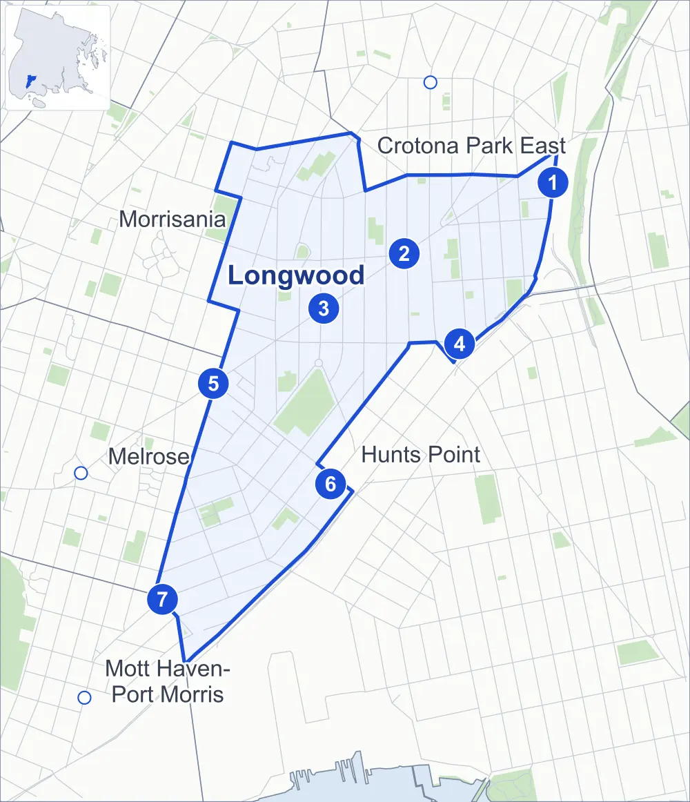
- Longwood
- A neighboring area
- Park
- A station in the list
- Another station
Neighborhood areas and streets: NYC Department of City Planning. Parks: NYC Parks. Stations: MTA.
Neighboring areas
- Crotona Park East northeast
- Hunts Point south
- Melrose southwest
- Mott Haven-Port Morris southwest
- Morrisania northwest
Subway stations
- Whitlock Av lines 6
- Simpson St lines 2 5 accessible
- Intervale Av lines 2 5
- Hunts Point Av lines 6 accessible
- Prospect Av lines 2 5
- Longwood Av lines 6
- E 149 St lines 6 accessible
Getting around
Seven subway stations and buses on 11 routes stop in or at the edge of Longwood.
- 7 subway stations
- 3 of them listed by the MTA as fully accessible
- 11 local bus routes
Local bus routes
- Bx4
- Bx4A
- Bx5
- Bx6
- Bx6-SBS
- Bx17
- Bx19
- Bx27
- Bx35
- Bx46
- T102
Safety record
Between 2021 and 2025, its corners averaged more police-reported crashes than the average Bronx corner.
- 1,080 police-reported crashes at its corners
- 10.0 a corner, on average
- 8.0 the average Bronx corner
- 5 corners with a clean record
Signal or safety changes on City record, at 39 of its corners
- Leading pedestrian intervals
- 28
- Accessible pedestrian signals
- 25
- Turn calming
- 5
- Barnes Dance all-way crossings
- 3
- Enhanced crossings
- 1
- Safety Improvement Projects
- 1
Camera tickets
In 2025 its corners had more bus-lane camera tickets than school-zone speed or red-light tickets.
- 0 red-light camera tickets
- 1,185 school-zone speed camera tickets at six corners
- 7,492 bus-lane camera tickets at two corners
- Most speed tickets
- Timpson Place & Avenue St John, 314
- Most bus-lane tickets
- East 163rd Street & Simpson Street, 6,732
People and homes
The 2020 Census counted 40,289 residents in Longwood, about 73,300 per square mile.
- 14,417 homes, 2020 Census
- 2,505 homes added since April 2010, net, by City Planning's count
Half of its 1,305 residential lots hold buildings from 1931 or earlier, and 51% of them date from before 1940, by the City's tax lot records.
NYCHA developments
Three NYCHA developments, which NYCHA names by buildings' addresses, lie wholly or partly within Longwood.
Parks and landmarks
- Parkland
- 20 acres of NYC Parks property
- The largest pieces
- Bill Rainey Park (7.7 acres), Al Quiñones Playground (1.8 acres) and Rev J Polite Playground (1.8 acres)
- Designated landmark
- 62nd Police Precinct Station House
- Historic districts
- Longwood and Longwood Extension, wholly or partly within Longwood
Streets and trees
- Trees
- 3,049 in NYC Parks' records, most often thornless honeylocust, London planetree and Callery pear
- Street with the most corners
- Westchester Avenue, with 18 of the area's 108
- Height above sea level
- From 26 feet at Intervale Avenue & Beck Street to 87 feet at Tinton Avenue & Home Street
- Honorary street names
- 28 at its corners, enacted by local law
Schools
The City lists 23 schools in Longwood.
- Public schools
- 14
- Charter and private schools
- 9
Bike share
By the station list of October 3, 2026, 16 bike-share stations stand in Longwood.
- 16 bike-share stations
Public safety
How complaints are countedIn 2025 the NYPD recorded 724 major felonies at places in Longwood.
Recorded by the NYPD at places in Longwood
- 843 major felonies in 2024
- 2,817 other felonies, misdemeanors and violations in 2025
In 2025, on the streets along the edge of Longwood, the NYPD recorded another 242 major felonies. Counting the streets along its edge, in 2025 the NYPD recorded 24.0 major felonies for every thousand residents the 2020 Census counted in Longwood.
- Police precincts
- 41st (most of the area), 42nd
From January to June 2026 the NYPD recorded 289 major felonies at places in Longwood, against 374 in the same months of 2025.
Sources: the NYPD's Complaint Data Historic, updated April 28, 2026, and Complaint Data Current (Year To Date), updated July 27, 2026, on NYC Open Data. Figures to June 30, 2026.
Street corners
- Beck Street & Avenue St John
- Beck Street & Leggett Avenue
- Bryant Avenue & Aldus Street
- Bryant Avenue & Bryant Avenue Pedestrian Overpass
- Bryant Avenue & East 165th Street
- Dawson Street & Leggett Avenue
- Dawson Street & Rogers Place
- East 149th Street & Timpson Place
- East 156th Street & Beck Street
- East 156th Street & Dawson Street
- East 156th Street & Fox Street
- East 156th Street & Hewitt Place
- East 156th Street & Kelly Street
- East 161st Street & Hewitt Place
- East 163rd Street & Fox Street
- East 163rd Street & Hoe Avenue
- East 163rd Street & Intervale Avenue
- East 163rd Street & Kelly Street
- East 163rd Street & Rev James A Polite Avenue
- East 163rd Street & Rogers Place
- East 163rd Street & Simpson Street
- East 163rd Street & Tiffany Street
- East 164th Street & Rev James A Polite Avenue
- East 165th Street & Faile Street
- East 165th Street & Fox Street
- East 165th Street & Hoe Avenue
- East 165th Street & Intervale Avenue
- East 165th Street & Kelly Street
- East 165th Street & Longfellow Avenue
- East 165th Street & Rev James A Polite Avenue
- East 165th Street & Rogers Place
- East 165th Street & Rogers Place at Hall Place
- East 165th Street & Tiffany Street
- East 165th Street & Union Avenue
- East 167th Street & Hoe Avenue
- East 167th Street & Intervale Avenue
- East 167th Street & Intervale Avenue at Hall Place
- East 167th Street & Kelly Street
- East 167th Street & Rev James A Polite Avenue
- East 169th Street & Intervale Avenue
- East 169th Street & Tiffany Street at Intervale Avenue
- Faile Street & Aldus Street
- Fox Street & Avenue St John
- Fox Street & Barretto Street
- Fox Street & Leggett Avenue
- Fox Street & Tiffany Street
- Hewitt Place & Macy Place
- Hoe Avenue & Aldus Street
- Hoe Avenue & West Farms Road
- Intervale Avenue & Beck Street
- Intervale Avenue & Dawson Street
- Intervale Avenue & Kelly Street (north)
- Intervale Avenue & Kelly Street (south)
- Kelly Street & Avenue St John
- Kelly Street & Leggett Avenue
- Kelly Street & Longwood Avenue
- Longfellow Avenue & Aldus Street
- Longfellow Avenue & Lowell Street
- Longfellow Avenue & Whitlock Avenue
- Longwood Avenue & Beck Street
- Longwood Avenue & Dawson Street
- Longwood Avenue & Hewitt Place
- Prospect Avenue & Avenue St John
- Prospect Avenue & Dawson Street
- Prospect Avenue & East 151st Street
- Prospect Avenue & East 156th Street
- Prospect Avenue & East 164th Street
- Prospect Avenue & East 165th Street
- Prospect Avenue & East 166th Street
- Prospect Avenue & East 167th Street
- Prospect Avenue & Home Street
- Prospect Avenue & Kelly Street
- Rev James A Polite Avenue & Dawson Street
- Rev James A Polite Avenue & East 166th Street
- Rev James A Polite Avenue & Home Street
- Simpson Street & Fire Access Lane
- Southern Boulevard & Aldus Street
- Southern Boulevard & Avenue St John
- Southern Boulevard & East 149th Street
- Southern Boulevard & East 156th Street
- Southern Boulevard & East 163rd Street
- Southern Boulevard & East 167th Street
- Southern Boulevard & Leggett Avenue
- Southern Boulevard & Westchester Avenue
- Tiffany Street & Beck Street
- Timpson Place & Avenue St John
- Tinton Avenue & Home Street
- Union Avenue & East 166th Street
- Union Avenue & East 167th Street
- Westchester Avenue & Bryant Avenue
- Westchester Avenue & East 161st Street
- Westchester Avenue & East 163rd Street
- Westchester Avenue & East 165th Street (north-east)
- Westchester Avenue & East 165th Street (south-west)
- Westchester Avenue & Faile Street
- Westchester Avenue & Fox Street
- Westchester Avenue & Hewitt Place
- Westchester Avenue & Hoe Avenue
- Westchester Avenue & Home Street
- Westchester Avenue & Intervale Avenue
- Westchester Avenue & Kelly Street
- Westchester Avenue & Longfellow Avenue
- Westchester Avenue & Rogers Place
- Westchester Avenue & Simpson Street
- Westchester Avenue & Tiffany Street
- Westchester Avenue & West Farms Road
- Whitlock Avenue & Aldus Street
- Whitlock Avenue & Lowell Street
How the figures above are measured: Methodology.